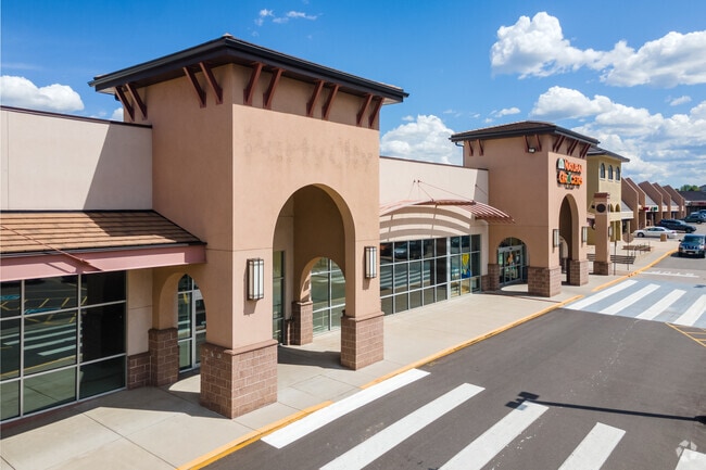
Property Record
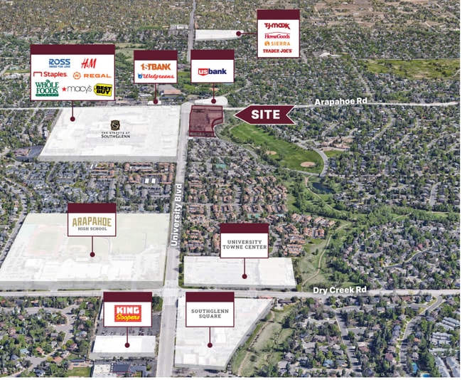
6770 S University Blvd, Littleton, CO 80122

NEARBY LISTINGS FOR SALE OR LEASE
Property Detail
6770 S University Blvd
Denver-Aurora-Lakewood, CO
Cherry Knolls Shopping Center
2077-25-2-13-008
PORTION LOT1
Storebuilding
Arapahoe
X
Colorado
08005C0452L
001
2023
2.71 AC
2024
South
005627
Denver
33,076 SF
DEMOGRAPHICS near 6770 S University Blvd
1 Mile
3 Mile
5 Mile
2024 Total Population
12,022
101,361
291,611
2029 Population
11,945
103,116
304,039
Pop Growth 2024-2029
(0.64%)
+ 1.73%
+ 4.26%
Average Age
44
43
41
2024 Total Households
4,849
40,449
121,508
HH Growth 2024-2029
(0.70%)
+ 1.88%
+ 4.08%
Median Household Inc
$100,665
$111,769
$108,673
Avg Household Size
2.40
2.50
2.30
2024 Avg HH Vehicles
2.00
2.00
2.00
Median Home Value
$618,035
$667,281
$649,054
Median Year Built
1970
1978
1986
Nearby Places
Map Layers
Map Styles
 Street
 Aerial
- Restaurants
- Banks
- Shops
- Fitness
- Groceries
PUBLIC TRANSPORTATION
AIRPORT
Denver International
DRIVE
WALK
Distance
Denver International
41 min
32.5 mi
Freight Ports
Tulsa Port Of Catoosa
DRIVE
WALK
Distance
Tulsa Port Of Catoosa
738 min
715.2 mi
SALE & LEASE HISTORY
LISTING DATE
SALE/LEASE

Oct 05, 2021
For Lease
Mar 22, 2018
For Lease
Jan 31, 2021
For Lease
Jan 20, 2017
For Lease
Nearby Properties
Address
Land Use
TOTAL SIZE
Lot Size
Zoning
Address
Land Use
TOTAL SIZE
Lot Size
Zoning
390,078 SF
38.27 AC
Address
Land Use
TOTAL SIZE
Lot Size
Zoning
207,637 SF
28.17 AC
PDU
Address
Land Use
TOTAL SIZE
Lot Size
Zoning
167,287 SF
13.65 AC
Address
Land Use
TOTAL SIZE
Lot Size
Zoning
177,772 SF
16 AC
Address
Land Use
TOTAL SIZE
Lot Size
Zoning
163,695 SF
22.90 AC
Address
Land Use
TOTAL SIZE
Lot Size
Zoning
329,937 SF
35.07 AC
PUD
Address
Land Use
TOTAL SIZE
Lot Size
Zoning
572,657 SF
0.21 AC
LPD-C
Address
Land Use
TOTAL SIZE
Lot Size
Zoning
411,924 SF
26.85 AC
LPDI
Address
Land Use
TOTAL SIZE
Lot Size
Zoning
192,108 SF
20.03 AC
Address
Land Use
TOTAL SIZE
Lot Size
Zoning
312,130 SF
20.63 AC
PDU
Address
Land Use
TOTAL SIZE
Lot Size
Zoning
250,402 SF
21 AC
Address
Land Use
TOTAL SIZE
Lot Size
Zoning
196,318 SF
4.50 AC
ARP
Address
Land Use
TOTAL SIZE
Lot Size
Zoning
206,632 SF
33.68 AC
Address
Land Use
TOTAL SIZE
Lot Size
Zoning
61,607 SF
11.60 AC
LPD-C
Address
Land Use
TOTAL SIZE
Lot Size
Zoning
463,840 SF
17.63 AC
PDU
Address
Land Use
TOTAL SIZE
Lot Size
Zoning
146,156 SF
4.61 AC
Address
Land Use
TOTAL SIZE
Lot Size
Zoning
248,058 SF
12.24 AC
Address
Land Use
TOTAL SIZE
Lot Size
Zoning
677,688 SF
2.97 AC
Address
Land Use
TOTAL SIZE
Lot Size
Zoning
152,384 SF
12.89 AC
PDU
Address
Land Use
TOTAL SIZE
Lot Size
Zoning
319,593 SF
12.78 AC
PUD
Address
Land Use
TOTAL SIZE
Lot Size
Zoning
255,868 SF
35.96 AC
Address
Land Use
TOTAL SIZE
Lot Size
Zoning
146,877 SF
11.52 AC
Address
Land Use
TOTAL SIZE
Lot Size
Zoning
128,655 SF
16.18 AC
AI1
Address
Land Use
TOTAL SIZE
Lot Size
Zoning
68,000 SF
7.47 AC
Address
Land Use
TOTAL SIZE
Lot Size
Zoning
143,303 SF
19.83 AC
Address
Land Use
TOTAL SIZE
Lot Size
Zoning
80,576 SF
11.44 AC
Address
Land Use
TOTAL SIZE
Lot Size
Zoning
131,886 SF
8.39 AC
Address
Land Use
TOTAL SIZE
Lot Size
Zoning
99,288 SF
2.62 AC
Address
Land Use
TOTAL SIZE
Lot Size
Zoning
40,343 SF
4.37 AC
Address
Land Use
TOTAL SIZE
Lot Size
Zoning
308,385 SF
2.19 AC
The World's #1 Commercial Real Estate Marketplace
Connect with us
© 2025 CoStar Group
The information above has been obtained from sources believed reliable. While we do not doubt its accuracy we have not verified it and make no guarantee, warranty or representation about it. It is your responsibility to independently confirm its accuracy and completeness. Any projections, opinions, assumptions, or estimates used are for example only and do not represent the current or future performance of the property. The value of this transaction to you depends on tax and other factors which should be evaluated by your tax, financial, and legal advisors. You and your advisors should conduct a careful, independent investigation of the property to determine to your satisfaction the suitability of the property for your needs.