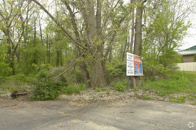
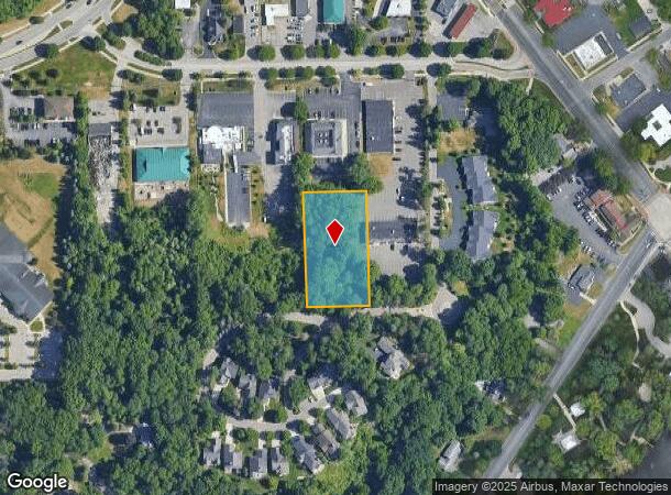
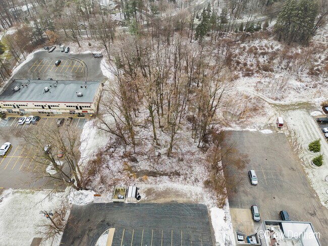
Property Record
6772 Old 28Th St Se, Grand Rapids, MI 49546
NEARBY LISTINGS FOR SALE OR LEASE
-
-
View all Grand Rapids listings for sale on LoopNet.com
Property Detail
6772 Old 28Th St Se
41-19-16-126-037
S 300 FT OF N 627 FT OF W 165 FT OF E 363 FT OF NW 1/4 * SEC 16 T6N R10W 1.14 A.
Commercialacreage
Kent
X
Michigan
26081C0442D
49,658 AC
2024
SE Grand Rapids/Cascade
2025
West Michigan
012203
Grand Rapids-Wyoming, MI
DEMOGRAPHICS near 6772 Old 28Th St Se
1 Mile
3 Mile
5 Mile
2024 Total Population
5,602
23,102
63,581
2029 Population
5,640
23,374
64,289
Pop Growth 2024-2029
+ 0.68%
+ 1.18%
+ 1.11%
Average Age
43
41
39
2024 Total Households
2,172
8,370
23,840
HH Growth 2024-2029
+ 0.64%
+ 1.16%
+ 1.10%
Median Household Inc
$109,116
$120,487
$94,038
Avg Household Size
2.50
2.70
2.50
2024 Avg HH Vehicles
2.00
2.00
2.00
Median Home Value
$370,340
$388,797
$355,494
Median Year Built
1981
1985
1985
Nearby Places
Map Layers
Map Styles
 Street
 Aerial
- Restaurants
- Banks
- Shops
- Fitness
- Groceries
PUBLIC TRANSPORTATION
AIRPORT
Gerald R Ford International
DRIVE
WALK
Distance
Gerald R Ford International
15 min
7.3 mi
SALE & LEASE HISTORY
LISTING DATE
SALE/LEASE

May 20, 2023
For Sale
Nearby Properties
Address
Land Use
TOTAL SIZE
Lot Size
Zoning
Address
Land Use
TOTAL SIZE
Lot Size
Zoning
23.99 AC
PUD
Address
Land Use
TOTAL SIZE
Lot Size
Zoning
285,875 SF
37.86 AC
TI
Address
Land Use
TOTAL SIZE
Lot Size
Zoning
184,186 SF
19.24 AC
R4
Address
Land Use
TOTAL SIZE
Lot Size
Zoning
236,061 SF
11.09 AC
PUD
Address
Land Use
TOTAL SIZE
Lot Size
Zoning
529,904 SF
20.04 AC
I1
Address
Land Use
TOTAL SIZE
Lot Size
Zoning
45,075 SF
20.54 AC
C2
Address
Land Use
TOTAL SIZE
Lot Size
Zoning
362,686 SF
20.99 AC
TI
Address
Land Use
TOTAL SIZE
Lot Size
Zoning
117,572 SF
14.89 AC
B2
Address
Land Use
TOTAL SIZE
Lot Size
Zoning
317,875 SF
24.04 AC
I
Address
Land Use
TOTAL SIZE
Lot Size
Zoning
57,495 SF
R1
Address
Land Use
TOTAL SIZE
Lot Size
Zoning
Address
Land Use
TOTAL SIZE
Lot Size
Zoning
247,984 SF
21.68 AC
B2
Address
Land Use
TOTAL SIZE
Lot Size
Zoning
11,200 SF
9.92 AC
PUD
Address
Land Use
TOTAL SIZE
Lot Size
Zoning
197,812 SF
14.78 AC
I
Address
Land Use
TOTAL SIZE
Lot Size
Zoning
Address
Land Use
TOTAL SIZE
Lot Size
Zoning
1,144 SF
4.15 AC
PUD
Address
Land Use
TOTAL SIZE
Lot Size
Zoning
255,790 SF
16.21 AC
I1
Address
Land Use
TOTAL SIZE
Lot Size
Zoning
159,722 SF
12.25 AC
I
Address
Land Use
TOTAL SIZE
Lot Size
Zoning
108,278 SF
3.80 AC
I
Address
Land Use
TOTAL SIZE
Lot Size
Zoning
216,000 SF
11.40 AC
TI
Address
Land Use
TOTAL SIZE
Lot Size
Zoning
183,463 SF
12.27 AC
TI
Address
Land Use
TOTAL SIZE
Lot Size
Zoning
48,750 SF
33.45 AC
I
Address
Land Use
TOTAL SIZE
Lot Size
Zoning
135,803 SF
24.25 AC
C2
Address
Land Use
TOTAL SIZE
Lot Size
Zoning
209,610 SF
7.86 AC
TI
Address
Land Use
TOTAL SIZE
Lot Size
Zoning
200,000 SF
12.70 AC
TI
Address
Land Use
TOTAL SIZE
Lot Size
Zoning
200,000 SF
11.23 AC
TI
Address
Land Use
TOTAL SIZE
Lot Size
Zoning
33,540 SF
5.67 AC
PO
Address
Land Use
TOTAL SIZE
Lot Size
Zoning
119,613 SF
2.49 AC
I
Address
Land Use
TOTAL SIZE
Lot Size
Zoning
41,472 SF
8.39 AC
Address
Land Use
TOTAL SIZE
Lot Size
Zoning
193,483 SF
16.92 AC
TI
The World's #1 Commercial Real Estate Marketplace
Connect with us
© 2025 CoStar Group
The information above has been obtained from sources believed reliable. While we do not doubt its accuracy we have not verified it and make no guarantee, warranty or representation about it. It is your responsibility to independently confirm its accuracy and completeness. Any projections, opinions, assumptions, or estimates used are for example only and do not represent the current or future performance of the property. The value of this transaction to you depends on tax and other factors which should be evaluated by your tax, financial, and legal advisors. You and your advisors should conduct a careful, independent investigation of the property to determine to your satisfaction the suitability of the property for your needs.