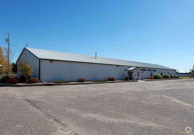
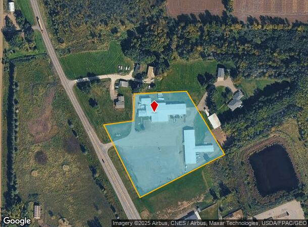
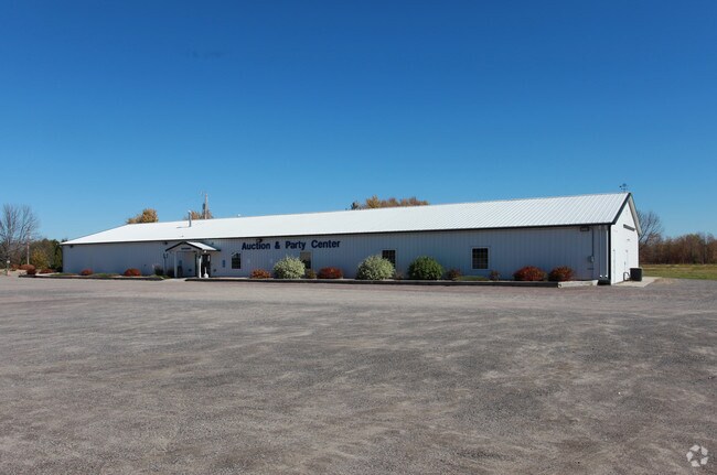
Property Record
6774 Highway 25 Ne, Foley, MN 56329
NEARBY LISTINGS FOR SALE OR LEASE
-
-
View all Foley listings for sale on LoopNet.com
Property Detail
6774 Highway 25 Ne
02.00361.00
SECT-26 TWP-037 RANGE-029 5.15 AC PART OF SW1/4 COMM AT INTERSEC OF SELY EXT OF NELY ROW LINE OF TRUNK HWY 25 TH NWLY 1063 FT
Commercialnec
Benton
X
Minnesota
27009C0216E
5.15 AC
2025
Benton County
2025
Minneapolis/St Paul
020100
St. Cloud, MN
12,660 SF
DEMOGRAPHICS near 6774 Highway 25 Ne
1 Mile
3 Mile
5 Mile
2024 Total Population
2,187
3,301
4,380
2029 Population
2,172
3,278
4,344
Pop Growth 2024-2029
(0.69%)
(0.70%)
(0.82%)
Average Age
36
36
37
2024 Total Households
805
1,207
1,598
HH Growth 2024-2029
(0.87%)
(0.75%)
(0.88%)
Median Household Inc
$73,874
$76,537
$79,377
Avg Household Size
2.60
2.60
2.70
2024 Avg HH Vehicles
2.00
2.00
2.00
Median Home Value
$180,511
$196,847
$229,775
Median Year Built
1978
1978
1978
Nearby Places
Map Layers
Map Styles
 Street
 Aerial
- Restaurants
- Banks
- Shops
- Fitness
- Groceries
SALE & LEASE HISTORY
LISTING DATE
SALE/LEASE

Nov 14, 2018
For Sale
Nearby Properties
Address
Land Use
TOTAL SIZE
Lot Size
Zoning
Address
Land Use
TOTAL SIZE
Lot Size
Zoning
174,398 SF
93.58 AC
Address
Land Use
TOTAL SIZE
Lot Size
Zoning
80,141 SF
14.05 AC
Address
Land Use
TOTAL SIZE
Lot Size
Zoning
26,250 SF
7.39 AC
Address
Land Use
TOTAL SIZE
Lot Size
Zoning
41,096 SF
1.07 AC
Address
Land Use
TOTAL SIZE
Lot Size
Zoning
22,570 SF
2.03 AC
Address
Land Use
TOTAL SIZE
Lot Size
Zoning
4.59 AC
Address
Land Use
TOTAL SIZE
Lot Size
Zoning
30,328 SF
40.91 AC
Address
Land Use
TOTAL SIZE
Lot Size
Zoning
25,250 SF
0.99 AC
Address
Land Use
TOTAL SIZE
Lot Size
Zoning
2.30 AC
Address
Land Use
TOTAL SIZE
Lot Size
Zoning
14,013 SF
6.88 AC
Address
Land Use
TOTAL SIZE
Lot Size
Zoning
29,060 SF
3.15 AC
Address
Land Use
TOTAL SIZE
Lot Size
Zoning
22,560 SF
1.16 AC
Address
Land Use
TOTAL SIZE
Lot Size
Zoning
22,560 SF
0.86 AC
Address
Land Use
TOTAL SIZE
Lot Size
Zoning
5,142 SF
5.63 AC
Address
Land Use
TOTAL SIZE
Lot Size
Zoning
39,320 SF
3.99 AC
Address
Land Use
TOTAL SIZE
Lot Size
Zoning
17,448 SF
0.66 AC
Address
Land Use
TOTAL SIZE
Lot Size
Zoning
41,304 SF
8.77 AC
Address
Land Use
TOTAL SIZE
Lot Size
Zoning
21,744 SF
1.31 AC
Address
Land Use
TOTAL SIZE
Lot Size
Zoning
14,960 SF
1.90 AC
Address
Land Use
TOTAL SIZE
Lot Size
Zoning
16,432 SF
0.89 AC
Address
Land Use
TOTAL SIZE
Lot Size
Zoning
10,000 SF
4.37 AC
Address
Land Use
TOTAL SIZE
Lot Size
Zoning
10,836 SF
3.13 AC
Address
Land Use
TOTAL SIZE
Lot Size
Zoning
12,032 SF
5.85 AC
Address
Land Use
TOTAL SIZE
Lot Size
Zoning
9,964 SF
0.21 AC
Address
Land Use
TOTAL SIZE
Lot Size
Zoning
12,520 SF
3.24 AC
Address
Land Use
TOTAL SIZE
Lot Size
Zoning
6,112 SF
1.14 AC
Address
Land Use
TOTAL SIZE
Lot Size
Zoning
2,816 SF
19.70 AC
Address
Land Use
TOTAL SIZE
Lot Size
Zoning
9,353 SF
0.73 AC
The World's #1 Commercial Real Estate Marketplace
Connect with us
© 2026 CoStar Group
The information above has been obtained from sources believed reliable. While we do not doubt its accuracy we have not verified it and make no guarantee, warranty or representation about it. It is your responsibility to independently confirm its accuracy and completeness. Any projections, opinions, assumptions, or estimates used are for example only and do not represent the current or future performance of the property. The value of this transaction to you depends on tax and other factors which should be evaluated by your tax, financial, and legal advisors. You and your advisors should conduct a careful, independent investigation of the property to determine to your satisfaction the suitability of the property for your needs.