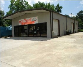
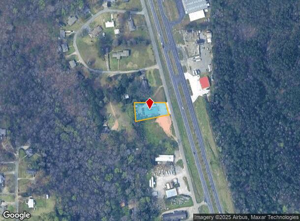
Property Record
6774 Old Highway 31 N, Gardendale, AL 35071

NEARBY LISTINGS FOR SALE OR LEASE
Property Detail
6774 Old Highway 31 N
07-00-26-1-000-035.002
COM SE COR OF SW 1/4 OF NE 1/4 SEC 26 TP15S R3W TH W 252.1 FT TH NWLY ALG R/W 235.4 FT TO POB TH CONT NW 85 FT TH W 206 FT TH SE 119.7 FT TH NE 227.8 FT TO POB
Commercialnec
Jefferson
X
Alabama
01073C0205H
0.52 AC
2023
Fultondale
2024
Birmingham
011704
Birmingham-Hoover, AL
2,200 SF
DEMOGRAPHICS near 6774 Old Highway 31 N
1 Mile
3 Mile
5 Mile
2024 Total Population
1,101
6,985
24,393
2029 Population
1,067
6,765
23,677
Pop Growth 2024-2029
(3.09%)
(3.15%)
(2.94%)
Average Age
43
42
41
2024 Total Households
440
2,809
9,589
HH Growth 2024-2029
(3.18%)
(3.24%)
(3.05%)
Median Household Inc
$59,042
$62,062
$76,288
Avg Household Size
2.50
2.40
2.50
2024 Avg HH Vehicles
2.00
2.00
2.00
Median Home Value
$206,061
$206,196
$214,266
Median Year Built
1983
1985
1987
Nearby Places
Map Layers
Map Styles
 Street
 Aerial
- Restaurants
- Banks
- Shops
- Fitness
- Groceries
PUBLIC TRANSPORTATION
AIRPORT
Birmingham-Shuttlesworth International
DRIVE
WALK
Distance
Birmingham-Shuttlesworth International
28 min
20.7 mi
Freight Ports
Port of Mobile
DRIVE
WALK
Distance
Port of Mobile
297 min
270.5 mi
Nearby Properties
Address
Land Use
TOTAL SIZE
Lot Size
Zoning
Address
Land Use
TOTAL SIZE
Lot Size
Zoning
55,872 SF
5.20 AC
C2
Address
Land Use
TOTAL SIZE
Lot Size
Zoning
27,112 SF
3.82 AC
C2
Address
Land Use
TOTAL SIZE
Lot Size
Zoning
39,750 SF
6 AC
C2
Address
Land Use
TOTAL SIZE
Lot Size
Zoning
19,246 SF
1.56 AC
B-2
Address
Land Use
TOTAL SIZE
Lot Size
Zoning
33,598 SF
5 AC
C2
Address
Land Use
TOTAL SIZE
Lot Size
Zoning
20,614 SF
16 AC
A1-I
Address
Land Use
TOTAL SIZE
Lot Size
Zoning
11,480 SF
2.78 AC
B1
Address
Land Use
TOTAL SIZE
Lot Size
Zoning
14,984 SF
2.10 AC
A1
Address
Land Use
TOTAL SIZE
Lot Size
Zoning
13,206 SF
5.20 AC
C2
Address
Land Use
TOTAL SIZE
Lot Size
Zoning
31,148 SF
46 AC
B
Address
Land Use
TOTAL SIZE
Lot Size
Zoning
13,931 SF
3.31 AC
B1
Address
Land Use
TOTAL SIZE
Lot Size
Zoning
13,376 SF
4.27 AC
C2
Address
Land Use
TOTAL SIZE
Lot Size
Zoning
74,400 SF
7 AC
I35
Address
Land Use
TOTAL SIZE
Lot Size
Zoning
18,922 SF
1.54 AC
INST
Address
Land Use
TOTAL SIZE
Lot Size
Zoning
14,758 SF
2.83 AC
B1
Address
Land Use
TOTAL SIZE
Lot Size
Zoning
12,511 SF
2.84 AC
C-2
Address
Land Use
TOTAL SIZE
Lot Size
Zoning
9,504 SF
1.30 AC
B2
Address
Land Use
TOTAL SIZE
Lot Size
Zoning
18,160 SF
1.06 AC
C-P
Address
Land Use
TOTAL SIZE
Lot Size
Zoning
10,700 SF
0.88 AC
B1
Address
Land Use
TOTAL SIZE
Lot Size
Zoning
11,510 SF
3.70 AC
C2
Address
Land Use
TOTAL SIZE
Lot Size
Zoning
15,600 SF
1.76 AC
C2
Address
Land Use
TOTAL SIZE
Lot Size
Zoning
Address
Land Use
TOTAL SIZE
Lot Size
Zoning
3,280 SF
2.30 AC
C-2
Address
Land Use
TOTAL SIZE
Lot Size
Zoning
10,920 SF
0.87 AC
C2
Address
Land Use
TOTAL SIZE
Lot Size
Zoning
19,842 SF
1.98 AC
CI
Address
Land Use
TOTAL SIZE
Lot Size
Zoning
18,000 SF
8.08 AC
I
Address
Land Use
TOTAL SIZE
Lot Size
Zoning
16,731 SF
10.40 AC
R4/R
Address
Land Use
TOTAL SIZE
Lot Size
Zoning
10,000 SF
2.29 AC
C2
Address
Land Use
TOTAL SIZE
Lot Size
Zoning
15,488 SF
1.67 AC
R1
Address
Land Use
TOTAL SIZE
Lot Size
Zoning
10,800 SF
2.60 AC
B1
The World's #1 Commercial Real Estate Marketplace
Connect with us
© 2025 CoStar Group
The information above has been obtained from sources believed reliable. While we do not doubt its accuracy we have not verified it and make no guarantee, warranty or representation about it. It is your responsibility to independently confirm its accuracy and completeness. Any projections, opinions, assumptions, or estimates used are for example only and do not represent the current or future performance of the property. The value of this transaction to you depends on tax and other factors which should be evaluated by your tax, financial, and legal advisors. You and your advisors should conduct a careful, independent investigation of the property to determine to your satisfaction the suitability of the property for your needs.