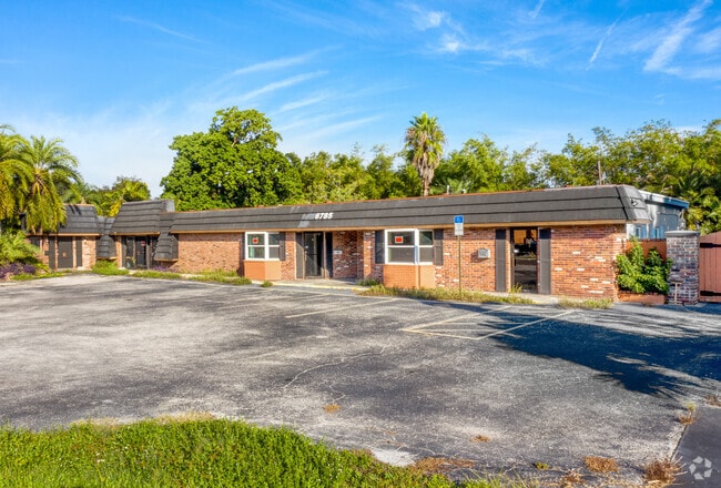
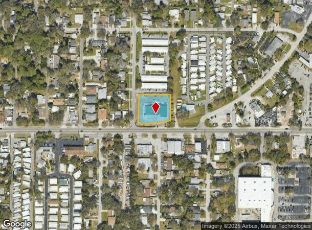
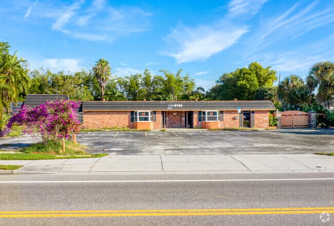
Property Record
6785 46Th Ave N, Saint Petersburg, FL 33709
NEARBY LISTINGS FOR SALE OR LEASE
Property Detail
6785 46Th Ave N
06-31-16-70020-100-3104
Pinellas Farms
Municipalproperty
PINELLAS FARMS NE 1/4, SEC 06-31-16 PART OF FARM 31 DESC FROM SW COR OF SE 1/4 OF NE 1/4 OF SD SEC TH N 65FT TH E 30FT FOR POB TH N01D0214E 184.36FT TH E 215FT(S) TH S 174FT(S) TO N R/W OF CR 16 TH WLY 205 FT(S) ALG SD R/W TH N45D1729W 20.72FT TO POB
X
Pinellas
12103C0203J
Florida
0
0.94 AC
2025
South Pinellas
025018
Tampa/St Petersburg
10,706 SF
Tampa-St. Petersburg-Clearwater, FL
DEMOGRAPHICS near 6785 46Th Ave N
1 Mile
3 Mile
5 Mile
2024 Total Population
16,371
101,776
263,370
2029 Population
16,424
101,685
264,613
Pop Growth 2024-2029
+ 0.32%
(0.09%)
+ 0.47%
Average Age
45
44
46
2024 Total Households
6,938
43,799
120,283
HH Growth 2024-2029
+ 0.12%
(0.31%)
+ 0.47%
Median Household Inc
$48,154
$58,203
$59,604
Avg Household Size
2.20
2.20
2.10
2024 Avg HH Vehicles
2.00
2.00
2.00
Median Home Value
$189,025
$239,498
$252,629
Median Year Built
1968
1968
1970
Nearby Places
Map Layers
Map Styles
 Street
 Aerial
- Restaurants
- Banks
- Shops
- Fitness
- Groceries
PUBLIC TRANSPORTATION
AIRPORT
St Pete-Clearwater International
DRIVE
WALK
Distance
St Pete-Clearwater International
24 min
10.7 mi
Tampa International
DRIVE
WALK
Distance
Tampa International
34 min
21.2 mi
Freight Ports
Port Manatee
DRIVE
WALK
Distance
Port Manatee
44 min
31.5 mi
Nearby Properties
Address
Land Use
TOTAL SIZE
Lot Size
Zoning
Address
Land Use
TOTAL SIZE
Lot Size
Zoning
2,167,184 SF
297.75 AC
PSP
Address
Land Use
TOTAL SIZE
Lot Size
Zoning
459,848 SF
19.74 AC
R6
Address
Land Use
TOTAL SIZE
Lot Size
Zoning
738,882 SF
43.34 AC
Address
Land Use
TOTAL SIZE
Lot Size
Zoning
396,428 SF
19.76 AC
Address
Land Use
TOTAL SIZE
Lot Size
Zoning
206,685 SF
16.75 AC
RPD5
Address
Land Use
TOTAL SIZE
Lot Size
Zoning
263,050 SF
34.20 AC
Address
Land Use
TOTAL SIZE
Lot Size
Zoning
142,529 SF
46.62 AC
Address
Land Use
TOTAL SIZE
Lot Size
Zoning
186,094 SF
11.96 AC
Address
Land Use
TOTAL SIZE
Lot Size
Zoning
127,237 SF
10.53 AC
Address
Land Use
TOTAL SIZE
Lot Size
Zoning
150,235 SF
17.90 AC
Address
Land Use
TOTAL SIZE
Lot Size
Zoning
195,863 SF
18.57 AC
Address
Land Use
TOTAL SIZE
Lot Size
Zoning
360,137 SF
37.64 AC
AE
Address
Land Use
TOTAL SIZE
Lot Size
Zoning
156,994 SF
29.11 AC
Address
Land Use
TOTAL SIZE
Lot Size
Zoning
172,600 SF
20.57 AC
Address
Land Use
TOTAL SIZE
Lot Size
Zoning
172,768 SF
15.05 AC
RPD20
Address
Land Use
TOTAL SIZE
Lot Size
Zoning
144,334 SF
2.50 AC
Address
Land Use
TOTAL SIZE
Lot Size
Zoning
116,358 SF
12.74 AC
Address
Land Use
TOTAL SIZE
Lot Size
Zoning
248,572 SF
15.22 AC
PSP
Address
Land Use
TOTAL SIZE
Lot Size
Zoning
48,862 SF
3.72 AC
Address
Land Use
TOTAL SIZE
Lot Size
Zoning
220,805 SF
5.93 AC
Address
Land Use
TOTAL SIZE
Lot Size
Zoning
145,047 SF
12.03 AC
Address
Land Use
TOTAL SIZE
Lot Size
Zoning
154,986 SF
11.08 AC
Address
Land Use
TOTAL SIZE
Lot Size
Zoning
46,749 SF
5.80 AC
Address
Land Use
TOTAL SIZE
Lot Size
Zoning
49,898 SF
77.25 AC
Address
Land Use
TOTAL SIZE
Lot Size
Zoning
89,316 SF
9.24 AC
Address
Land Use
TOTAL SIZE
Lot Size
Zoning
119,580 SF
4.18 AC
Address
Land Use
TOTAL SIZE
Lot Size
Zoning
221,615 SF
16.33 AC
Address
Land Use
TOTAL SIZE
Lot Size
Zoning
117,837 SF
11.92 AC
Address
Land Use
TOTAL SIZE
Lot Size
Zoning
137,240 SF
11.38 AC
RPD125
Address
Land Use
TOTAL SIZE
Lot Size
Zoning
99,045 SF
8.79 AC
The World's #1 Commercial Real Estate Marketplace
Connect with us
© 2025 CoStar Group
The information above has been obtained from sources believed reliable. While we do not doubt its accuracy we have not verified it and make no guarantee, warranty or representation about it. It is your responsibility to independently confirm its accuracy and completeness. Any projections, opinions, assumptions, or estimates used are for example only and do not represent the current or future performance of the property. The value of this transaction to you depends on tax and other factors which should be evaluated by your tax, financial, and legal advisors. You and your advisors should conduct a careful, independent investigation of the property to determine to your satisfaction the suitability of the property for your needs.