Property Record
6785 Whitneyville Ave Se, Alto, MI 49302

NEARBY LISTINGS FOR SALE OR LEASE
-
-
View all Alto listings for sale on LoopNet.com
Property Detail
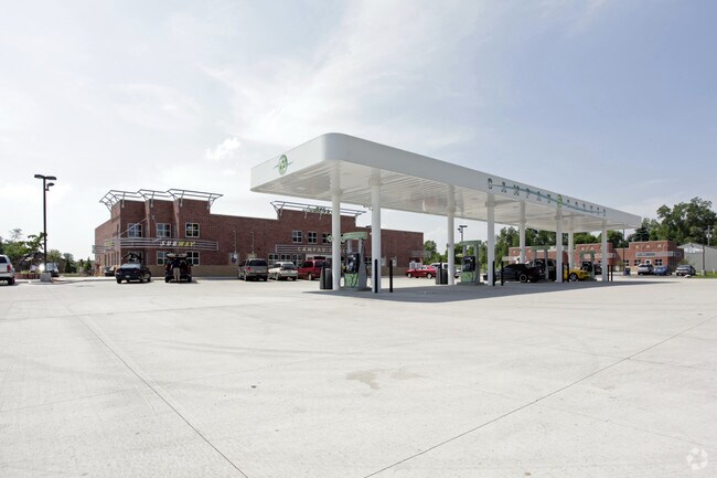
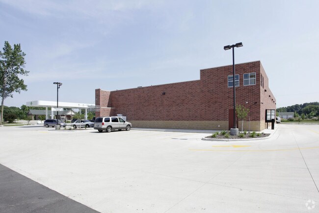
6785 Whitneyville Ave Se
41-23-02-376-010
S 301 FT OF E 400 FT OF S 1/2 SW 1/4 * SEC 2 T5N R10W 2.76 A.
Conveniencestore
Kent
X
Michigan
26081C0580D
2.76 AC
2024
SE Kent County/Caledonia
2025
West Michigan
014806
Grand Rapids-Wyoming-Kentwood, MI
7,993 SF
DEMOGRAPHICS near 6785 Whitneyville Ave Se
1 Mile
3 Mile
5 Mile
2024 Total Population
2,066
9,957
26,430
2029 Population
2,084
10,167
26,804
Pop Growth 2024-2029
+ 0.87%
+ 2.11%
+ 1.42%
Average Age
42
40
39
2024 Total Households
747
3,430
8,872
HH Growth 2024-2029
+ 0.94%
+ 2.07%
+ 1.48%
Median Household Inc
$102,747
$114,019
$107,314
Avg Household Size
2.80
2.90
2.90
2024 Avg HH Vehicles
2.00
2.00
2.00
Median Home Value
$323,111
$362,319
$340,696
Median Year Built
1987
1993
1991
Nearby Places
Map Layers
Map Styles
 Street
 Aerial
- Restaurants
- Banks
- Shops
- Fitness
- Groceries
PUBLIC TRANSPORTATION
AIRPORT
Gerald R Ford International
DRIVE
WALK
Distance
Gerald R Ford International
13 min
5.9 mi
Freight Ports
Port Milwaukee
DRIVE
WALK
Distance
Port Milwaukee
317 min
271.0 mi
Nearby Properties
Address
Land Use
TOTAL SIZE
Lot Size
Zoning
Address
Land Use
TOTAL SIZE
Lot Size
Zoning
438,644 SF
117.24 AC
PUD
Address
Land Use
TOTAL SIZE
Lot Size
Zoning
210,096 SF
75.30 AC
PUD
Address
Land Use
TOTAL SIZE
Lot Size
Zoning
9.71 AC
R3
Address
Land Use
TOTAL SIZE
Lot Size
Zoning
34.59 AC
PUD
Address
Land Use
TOTAL SIZE
Lot Size
Zoning
1,825 SF
128.19 AC
A
Address
Land Use
TOTAL SIZE
Lot Size
Zoning
19,800 SF
148.38 AC
Address
Land Use
TOTAL SIZE
Lot Size
Zoning
4,339 SF
63.28 AC
RR
Address
Land Use
TOTAL SIZE
Lot Size
Zoning
2,207 SF
63.63 AC
AG-1
Address
Land Use
TOTAL SIZE
Lot Size
Zoning
95.05 AC
A
Address
Land Use
TOTAL SIZE
Lot Size
Zoning
134.70 AC
I
Address
Land Use
TOTAL SIZE
Lot Size
Zoning
1,968 SF
25.51 AC
A
Address
Land Use
TOTAL SIZE
Lot Size
Zoning
29,179 SF
6.99 AC
PMR
Address
Land Use
TOTAL SIZE
Lot Size
Zoning
33.15 AC
RR
Address
Land Use
TOTAL SIZE
Lot Size
Zoning
1,981 SF
53.97 AC
RR
Address
Land Use
TOTAL SIZE
Lot Size
Zoning
130.98 AC
Address
Land Use
TOTAL SIZE
Lot Size
Zoning
32,768 SF
5 AC
C1
Address
Land Use
TOTAL SIZE
Lot Size
Zoning
77.16 AC
RR
Address
Land Use
TOTAL SIZE
Lot Size
Zoning
1,680 SF
50.92 AC
RR
Address
Land Use
TOTAL SIZE
Lot Size
Zoning
97.33 AC
Address
Land Use
TOTAL SIZE
Lot Size
Zoning
96.83 AC
Address
Land Use
TOTAL SIZE
Lot Size
Zoning
59.42 AC
ARC
Address
Land Use
TOTAL SIZE
Lot Size
Zoning
1,871 SF
53.77 AC
RR
Address
Land Use
TOTAL SIZE
Lot Size
Zoning
103.01 AC
Address
Land Use
TOTAL SIZE
Lot Size
Zoning
1,092 SF
79.50 AC
A
Address
Land Use
TOTAL SIZE
Lot Size
Zoning
1,428 SF
133.38 AC
AG-1
Address
Land Use
TOTAL SIZE
Lot Size
Zoning
2,262 SF
3.49 AC
R3
Address
Land Use
TOTAL SIZE
Lot Size
Zoning
70.90 AC
PMR
Address
Land Use
TOTAL SIZE
Lot Size
Zoning
9,100 SF
1.29 AC
C1
Address
Land Use
TOTAL SIZE
Lot Size
Zoning
117.17 AC
A
The World's #1 Commercial Real Estate Marketplace
Connect with us
© 2026 CoStar Group
The information above has been obtained from sources believed reliable. While we do not doubt its accuracy we have not verified it and make no guarantee, warranty or representation about it. It is your responsibility to independently confirm its accuracy and completeness. Any projections, opinions, assumptions, or estimates used are for example only and do not represent the current or future performance of the property. The value of this transaction to you depends on tax and other factors which should be evaluated by your tax, financial, and legal advisors. You and your advisors should conduct a careful, independent investigation of the property to determine to your satisfaction the suitability of the property for your needs.