Property Record
679 Central Ave E, Edgewater, MD 21037
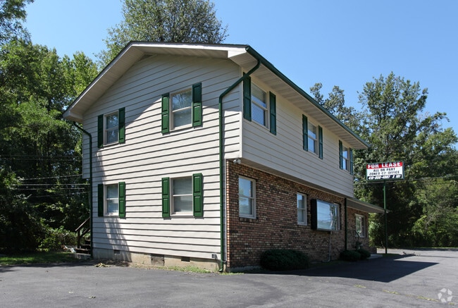


Property Detail
679 Central Ave E
01-000-02894522
Mayo
Officebuilding
.8 ACRE MAYO
X
Anne Arundel
24003C0241F
Maryland
2024
0.80 AC
2025
Southern Anne Arundel
701400
Baltimore
2,355 SF
Baltimore-Columbia-Towson, MD
NEARBY LISTINGS FOR SALE OR LEASE
DEMOGRAPHICS near 679 Central Ave E
1 mile
3 mile
5 mile
2024 Total Population
2,242
21,581
73,444
2029 Population
2,303
22,091
75,431
Pop Growth 2024-2029
+ 2.72%
+ 2.36%
+ 2.71%
Average Age
41
42
42
2024 Total Households
818
8,098
28,874
HH Growth 2024-2029
+ 2.81%
+ 2.41%
+ 2.83%
Median Household Inc
$142,079
$122,625
$115,635
Avg Household Size
2.70
2.60
2.50
2024 Avg HH Vehicles
2.00
2.00
2.00
Median Home Value
$616,356
$484,078
$515,214
Median Year Built
1992
1979
1980
Nearby Places
Map Layers
Map Styles
 Street
 Aerial
Transit
 Traffic
 Biking
Places
Listings with unknown addresses are not visible on the map
- Restaurants
- Banks
- Shops
- Fitness
- Groceries
PUBLIC TRANSPORTATION
AIRPORT
Baltimore/Washington International Thurgood Marshall
Drive
Walk
Distance
Baltimore/Washington International Thurgood Marshall
41 min
27.7 mi
Ronald Reagan Washington Ntl
Drive
Walk
Distance
Ronald Reagan Washington Ntl
53 min
33.1 mi
Freight Ports
Port of Baltimore
Drive
Walk
Distance
Port of Baltimore
47 min
33.0 mi
SALE & LEASE HISTORY
LISTING DATE
SALE/LEASE

Sep 29, 2017
For Sale
Jun 25, 2018
For Lease
Jul 23, 2018
For Sale
Nearby Properties
Address
Land Use
TOTAL SIZE
Lot Size
Zoning
Address
Land Use
TOTAL SIZE
Lot Size
Zoning
589,210 SF
111.38 AC
RA
Address
Land Use
TOTAL SIZE
Lot Size
Zoning
341.13 AC
R5
Address
Land Use
TOTAL SIZE
Lot Size
Zoning
112,662 SF
14.44 AC
C3
Address
Land Use
TOTAL SIZE
Lot Size
Zoning
77,261 SF
3.56 AC
C3
Address
Land Use
TOTAL SIZE
Lot Size
Zoning
94,932 SF
9.52 AC
C4
Address
Land Use
TOTAL SIZE
Lot Size
Zoning
15,093 SF
336.13 AC
R2
Address
Land Use
TOTAL SIZE
Lot Size
Zoning
61,141 SF
5.05 AC
C3
Address
Land Use
TOTAL SIZE
Lot Size
Zoning
62,532 SF
10.07 AC
C3
Address
Land Use
TOTAL SIZE
Lot Size
Zoning
48,572 SF
7.27 AC
R2
Address
Land Use
TOTAL SIZE
Lot Size
Zoning
15,000 SF
7.35 AC
C3
Address
Land Use
TOTAL SIZE
Lot Size
Zoning
55,348 SF
14.98 AC
R5
Address
Land Use
TOTAL SIZE
Lot Size
Zoning
39,568 SF
4.82 AC
C3
Address
Land Use
TOTAL SIZE
Lot Size
Zoning
46,664 SF
0.74 AC
C3
Address
Land Use
TOTAL SIZE
Lot Size
Zoning
23,890 SF
3.18 AC
C3
Address
Land Use
TOTAL SIZE
Lot Size
Zoning
25,142 SF
2.38 AC
C3
Address
Land Use
TOTAL SIZE
Lot Size
Zoning
55,649 SF
9.21 AC
R2
Address
Land Use
TOTAL SIZE
Lot Size
Zoning
15,007 SF
6.47 AC
C2
Address
Land Use
TOTAL SIZE
Lot Size
Zoning
38,004 SF
9.47 AC
R1
Address
Land Use
TOTAL SIZE
Lot Size
Zoning
16,243 SF
10 AC
OS
Address
Land Use
TOTAL SIZE
Lot Size
Zoning
117,528 SF
13.88 AC
C3
Address
Land Use
TOTAL SIZE
Lot Size
Zoning
31,363 SF
8.83 AC
R10
Address
Land Use
TOTAL SIZE
Lot Size
Zoning
40,462 SF
2.03 AC
C2
Address
Land Use
TOTAL SIZE
Lot Size
Zoning
4,795 SF
2.34 AC
MB
Address
Land Use
TOTAL SIZE
Lot Size
Zoning
106,824 SF
3.42 AC
C3
Address
Land Use
TOTAL SIZE
Lot Size
Zoning
12,198 SF
4.95 AC
OS
Address
Land Use
TOTAL SIZE
Lot Size
Zoning
12,021 SF
7.92 AC
R1
Address
Land Use
TOTAL SIZE
Lot Size
Zoning
13,478 SF
3.54 AC
R2
Address
Land Use
TOTAL SIZE
Lot Size
Zoning
11,225 SF
3.82 AC
R1
Address
Land Use
TOTAL SIZE
Lot Size
Zoning
45,704 SF
3 AC
C3
Address
Land Use
TOTAL SIZE
Lot Size
Zoning
8,796 SF
1.71 AC
R1
The World's #1 Commercial Real Estate Marketplace
Connect with us
© 2026 CoStar Group
The information above has been obtained from sources believed reliable. While we do not doubt its accuracy we have not verified it and make no guarantee, warranty or representation about it. It is your responsibility to independently confirm its accuracy and completeness. Any projections, opinions, assumptions, or estimates used are for example only and do not represent the current or future performance of the property. The value of this transaction to you depends on tax and other factors which should be evaluated by your tax, financial, and legal advisors. You and your advisors should conduct a careful, independent investigation of the property to determine to your satisfaction the suitability of the property for your needs.