Property Record
679 Edinburgh Way, Seneca, SC 29678
Save to a Folder
{{folder.Name}}
{{folder.ListingIds.length}} Properties
{{folder.ListingIds.length}} Property
Create a New Folder
Property Detail
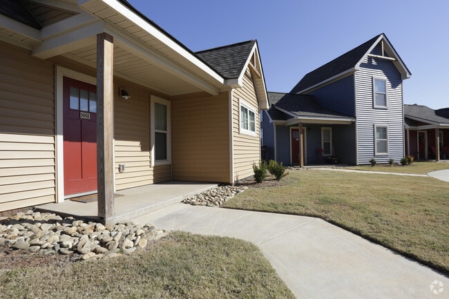
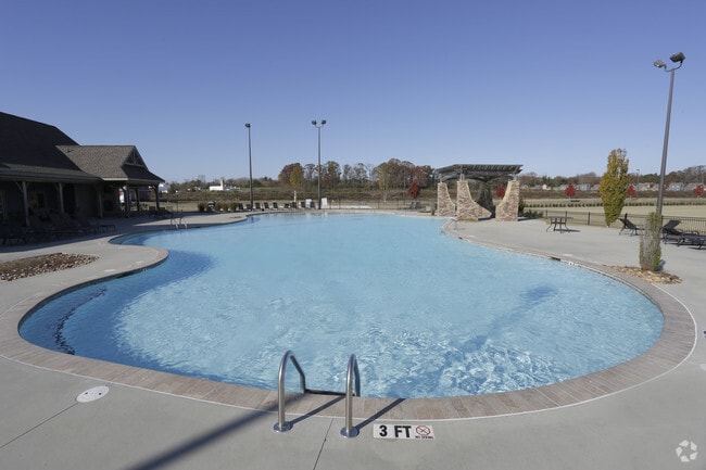
679 Edinburgh Way
271-01-01-126
CREEK VILLAGE WEST QUEENS PARK LOOP (2.623 AC
Recreationcenter
Oconee
B and X Area of moderate flood hazard, usually the area between the limits of the 100-year and 500-year floods.
South Carolina
2025
2.65 AC
2025
South Carolina Rural Areas
030801
Other Market Areas
6,529 SF
Seneca, SC
NEARBY LISTINGS FOR SALE OR LEASE
DEMOGRAPHICS near 679 Edinburgh Way
1 mile
3 mile
5 mile
2025 Total Population
1,237
9,944
36,852
2030 Population
1,296
10,287
38,309
Pop Growth 2025-2030
+ 4.77%
+ 3.45%
+ 3.95%
Average Age
36
30
36
2025 Total Households
549
2,570
13,731
HH Growth 2025-2030
+ 4.74%
+ 4.86%
+ 4.48%
Median Household Inc
$54,848
$48,076
$53,012
Avg Household Size
2.20
2.20
2.30
2025 Avg HH Vehicles
2.00
2.00
2.00
Median Home Value
$225,532
$291,272
$279,243
Median Year Built
1991
1989
1988
Nearby Places
Map Layers
Map Styles
 Street
 Aerial
Layers
 Traffic
 Biking
Places
Listings with unknown addresses are not visible on the map
- Restaurants
- Banks
- Shops
- Fitness
- Groceries
PUBLIC TRANSPORTATION
COMMUTER RAIL
Clemson Amtrak Station (Crescent - Amtrak)
Drive
Walk
Distance
Clemson Amtrak Station (Crescent - Amtrak)
12 min
5.7 mi
Freight Ports
Georgia Ports - Savannah
Drive
Walk
Distance
Georgia Ports - Savannah
321 min
228.2 mi
Nearby Properties
Address
Land Use
TOTAL SIZE
Lot Size
Zoning
Address
Land Use
TOTAL SIZE
Lot Size
Zoning
3,224.70 AC
NOT ZONED
Address
Land Use
TOTAL SIZE
Lot Size
Zoning
259,277 SF
3.39 AC
PD17
Address
Land Use
TOTAL SIZE
Lot Size
Zoning
26,864 SF
0.98 AC
GC
Address
Land Use
TOTAL SIZE
Lot Size
Zoning
6,574 SF
0.50 AC
RLC
Address
Land Use
TOTAL SIZE
Lot Size
Zoning
119,175 SF
2.11 AC
RM 3 MULTI
Address
Land Use
TOTAL SIZE
Lot Size
Zoning
267,298 SF
1.68 AC
GC
Address
Land Use
TOTAL SIZE
Lot Size
Zoning
6,000 SF
0.99 AC
Address
Land Use
TOTAL SIZE
Lot Size
Zoning
43,916 SF
0.25 AC
C
Address
Land Use
TOTAL SIZE
Lot Size
Zoning
0.78 AC
GENERAL CO
Address
Land Use
TOTAL SIZE
Lot Size
Zoning
0.54 AC
RLC
Address
Land Use
TOTAL SIZE
Lot Size
Zoning
Address
Land Use
TOTAL SIZE
Lot Size
Zoning
1 AC
GC
Address
Land Use
TOTAL SIZE
Lot Size
Zoning
5,484.32 AC
Address
Land Use
TOTAL SIZE
Lot Size
Zoning
0.52 AC
C
Address
Land Use
TOTAL SIZE
Lot Size
Zoning
0.48 AC
GC
Address
Land Use
TOTAL SIZE
Lot Size
Zoning
30,104 SF
0.27 AC
CP 1 NEIGH
Address
Land Use
TOTAL SIZE
Lot Size
Zoning
21,378 SF
0.95 AC
RLC RES LI
Address
Land Use
TOTAL SIZE
Lot Size
Zoning
53,460 SF
17.15 AC
Address
Land Use
TOTAL SIZE
Lot Size
Zoning
37,888 SF
2.93 AC
RM 2 TWO F
Address
Land Use
TOTAL SIZE
Lot Size
Zoning
0.34 AC
GC
Address
Land Use
TOTAL SIZE
Lot Size
Zoning
32,768 SF
5.88 AC
RM 2 TWO F
Address
Land Use
TOTAL SIZE
Lot Size
Zoning
20,972 SF
0.81 AC
RM 4 MULTI
Address
Land Use
TOTAL SIZE
Lot Size
Zoning
3.83 AC
RM 2 TWO F
Address
Land Use
TOTAL SIZE
Lot Size
Zoning
11,121 SF
1.77 AC
Address
Land Use
TOTAL SIZE
Lot Size
Zoning
23,552 SF
2.58 AC
RM2
Address
Land Use
TOTAL SIZE
Lot Size
Zoning
4.39 AC
RM 2 TWO F
Address
Land Use
TOTAL SIZE
Lot Size
Zoning
1.26 AC
Address
Land Use
TOTAL SIZE
Lot Size
Zoning
15,010 SF
1.05 AC
RM 4 MULTI
The World's #1 Commercial Real Estate Marketplace
Connect with us
© 2026 CoStar Group
The information above has been obtained from sources believed reliable. While we do not doubt its accuracy we have not verified it and make no guarantee, warranty or representation about it. It is your responsibility to independently confirm its accuracy and completeness. Any projections, opinions, assumptions, or estimates used are for example only and do not represent the current or future performance of the property. The value of this transaction to you depends on tax and other factors which should be evaluated by your tax, financial, and legal advisors. You and your advisors should conduct a careful, independent investigation of the property to determine to your satisfaction the suitability of the property for your needs.