Property Record
679 S Main St, Madisonville, KY 42431

This Property Is For Sale
NEARBY LISTINGS FOR SALE OR LEASE
Property Detail
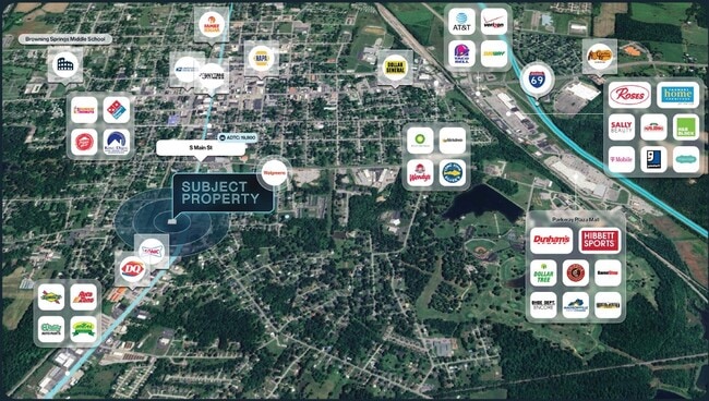
679 S Main St
Madisonville, KY
Horne Real Estates Llc
M-22-32-13
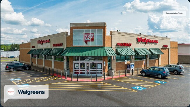
WALGREENS
Commercialnec
Hopkins
X
Kentucky
21107C0234D
1.85 AC
2025
Kentucky West Area
2025
Other Market Areas
970500
DEMOGRAPHICS near 679 S Main St
1 Mile
3 Mile
5 Mile
2024 Total Population
6,802
19,462
25,979
2029 Population
6,725
19,246
25,655
Pop Growth 2024-2029
(1.13%)
(1.11%)
(1.25%)
Average Age
40
41
41
2024 Total Households
2,943
8,173
10,763
HH Growth 2024-2029
(1.16%)
(1.13%)
(1.28%)
Median Household Inc
$45,982
$45,469
$47,890
Avg Household Size
2.20
2.20
2.30
2024 Avg HH Vehicles
2.00
2.00
2.00
Median Home Value
$117,072
$123,354
$130,866
Median Year Built
1967
1972
1974
Nearby Places
Map Layers
Map Styles
 Street
 Aerial
- Restaurants
- Banks
- Shops
- Fitness
- Groceries
Nearby Properties
Address
Land Use
TOTAL SIZE
Lot Size
Zoning
Address
Land Use
TOTAL SIZE
Lot Size
Zoning
22.86 AC
Address
Land Use
TOTAL SIZE
Lot Size
Zoning
Address
Land Use
TOTAL SIZE
Lot Size
Zoning
Address
Land Use
TOTAL SIZE
Lot Size
Zoning
Address
Land Use
TOTAL SIZE
Lot Size
Zoning
25.06 AC
COM
Address
Land Use
TOTAL SIZE
Lot Size
Zoning
19.98 AC
COM
Address
Land Use
TOTAL SIZE
Lot Size
Zoning
Address
Land Use
TOTAL SIZE
Lot Size
Zoning
20 AC
COM
Address
Land Use
TOTAL SIZE
Lot Size
Zoning
8 AC
COM
Address
Land Use
TOTAL SIZE
Lot Size
Zoning
35.20 AC
Address
Land Use
TOTAL SIZE
Lot Size
Zoning
22.66 AC
COM
Address
Land Use
TOTAL SIZE
Lot Size
Zoning
7.04 AC
COM
Address
Land Use
TOTAL SIZE
Lot Size
Zoning
39.63 AC
COM
Address
Land Use
TOTAL SIZE
Lot Size
Zoning
7.96 AC
COM
Address
Land Use
TOTAL SIZE
Lot Size
Zoning
3,332 SF
2.57 AC
COM
Address
Land Use
TOTAL SIZE
Lot Size
Zoning
21.19 AC
COM
Address
Land Use
TOTAL SIZE
Lot Size
Zoning
15.59 AC
Address
Land Use
TOTAL SIZE
Lot Size
Zoning
2.24 AC
Address
Land Use
TOTAL SIZE
Lot Size
Zoning
2.57 AC
COM
Address
Land Use
TOTAL SIZE
Lot Size
Zoning
17.91 AC
COM
Address
Land Use
TOTAL SIZE
Lot Size
Zoning
14.60 AC
Address
Land Use
TOTAL SIZE
Lot Size
Zoning
Address
Land Use
TOTAL SIZE
Lot Size
Zoning
1.85 AC
COM
Address
Land Use
TOTAL SIZE
Lot Size
Zoning
39.04 AC
COM
Address
Land Use
TOTAL SIZE
Lot Size
Zoning
5.40 AC
Address
Land Use
TOTAL SIZE
Lot Size
Zoning
54.34 AC
COM
Address
Land Use
TOTAL SIZE
Lot Size
Zoning
2.53 AC
COM
Address
Land Use
TOTAL SIZE
Lot Size
Zoning
3,528 SF
5 AC
COM
Address
Land Use
TOTAL SIZE
Lot Size
Zoning
10.67 AC
COM
Address
Land Use
TOTAL SIZE
Lot Size
Zoning
19,609 SF
3.57 AC
The World's #1 Commercial Real Estate Marketplace
Connect with us
© 2026 CoStar Group
The information above has been obtained from sources believed reliable. While we do not doubt its accuracy we have not verified it and make no guarantee, warranty or representation about it. It is your responsibility to independently confirm its accuracy and completeness. Any projections, opinions, assumptions, or estimates used are for example only and do not represent the current or future performance of the property. The value of this transaction to you depends on tax and other factors which should be evaluated by your tax, financial, and legal advisors. You and your advisors should conduct a careful, independent investigation of the property to determine to your satisfaction the suitability of the property for your needs.