Property Record
68-70 Main Ave, Passaic, NJ 07055
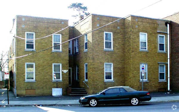

Property Detail
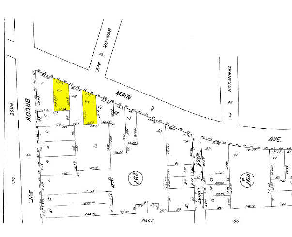
68-70 Main Ave
07-01297-0000-00064
INCL BLK 1297 LOTS 64 & 68
Apartment
Passaic
C-R
New Jersey
C and X Area of minimal flood hazard, usually depicted on FIRMs as above the 500-year flood level.
64
2024
0.11 AC
2025
Passaic
175701
Northern New Jersey
5,520 SF
New York-Jersey City-White Plains, NY-NJ
NEARBY LISTINGS FOR SALE OR LEASE
DEMOGRAPHICS near 68-70 Main Ave
1 mile
3 mile
5 mile
2025 Total Population
33,132
279,831
608,612
2030 Population
33,820
284,679
620,469
Pop Growth 2025-2030
+ 2.08%
+ 1.73%
+ 1.95%
Average Age
37
39
40
2025 Total Households
10,791
99,239
220,557
HH Growth 2025-2030
+ 2.10%
+ 1.77%
+ 2.09%
Median Household Inc
$89,475
$91,997
$93,033
Avg Household Size
3.00
2.70
2.70
2025 Avg HH Vehicles
2.00
2.00
2.00
Median Home Value
$559,564
$490,599
$487,367
Median Year Built
1952
1951
1953
Nearby Places
Map Layers
Map Styles
 Street
 Aerial
Layers
 Traffic
 Biking
Places
Listings with unknown addresses are not visible on the map
- Restaurants
- Banks
- Shops
- Fitness
- Groceries
PUBLIC TRANSPORTATION
TRANSIT/SUBWAY
Passaic (Main/Port Jervis Line - NJ Transit Commuter Rail (NJ Transit))
Drive
Walk
Distance
Passaic (Main/Port Jervis Line - NJ Transit Commuter Rail (NJ Transit))
2 min
13 min
0.7 mi
COMMUTER RAIL
Passaic (Main/Port Jervis Line - NJ Transit Commuter Rail (NJ Transit))
Drive
Walk
Distance
Passaic (Main/Port Jervis Line - NJ Transit Commuter Rail (NJ Transit))
2 min
15 min
0.8 mi
Delawanna (Main/Port Jervis Line - NJ Transit Commuter Rail (NJ Transit))
Drive
Walk
Distance
Delawanna (Main/Port Jervis Line - NJ Transit Commuter Rail (NJ Transit))
2 min
1.1 mi
AIRPORT
Newark Liberty International
Drive
Walk
Distance
Newark Liberty International
18 min
14.6 mi
LaGuardia
Drive
Walk
Distance
LaGuardia
38 min
21.1 mi
John F Kennedy International
Drive
Walk
Distance
John F Kennedy International
46 min
29.1 mi
Freight Ports
Maher Terminal
Drive
Walk
Distance
Maher Terminal
24 min
14.2 mi
Nearby Properties
Address
Land Use
TOTAL SIZE
Lot Size
Zoning
Address
Land Use
TOTAL SIZE
Lot Size
Zoning
612 AC
SEA
Address
Land Use
TOTAL SIZE
Lot Size
Zoning
Address
Land Use
TOTAL SIZE
Lot Size
Zoning
4,014 SF
21 AC
Address
Land Use
TOTAL SIZE
Lot Size
Zoning
9.57 AC
I2
Address
Land Use
TOTAL SIZE
Lot Size
Zoning
7.10 AC
R-3
Address
Land Use
TOTAL SIZE
Lot Size
Zoning
82.74 AC
Address
Land Use
TOTAL SIZE
Lot Size
Zoning
Address
Land Use
TOTAL SIZE
Lot Size
Zoning
Address
Land Use
TOTAL SIZE
Lot Size
Zoning
8.88 AC
ORD
Address
Land Use
TOTAL SIZE
Lot Size
Zoning
1,218 SF
41.30 AC
RB
Address
Land Use
TOTAL SIZE
Lot Size
Zoning
7.29 AC
Address
Land Use
TOTAL SIZE
Lot Size
Zoning
1.12 AC
M-O
Address
Land Use
TOTAL SIZE
Lot Size
Zoning
100,014 SF
8.80 AC
M2
Address
Land Use
TOTAL SIZE
Lot Size
Zoning
Address
Land Use
TOTAL SIZE
Lot Size
Zoning
2.42 AC
Address
Land Use
TOTAL SIZE
Lot Size
Zoning
71,634 SF
12.31 AC
M1
Address
Land Use
TOTAL SIZE
Lot Size
Zoning
24.29 AC
Address
Land Use
TOTAL SIZE
Lot Size
Zoning
Address
Land Use
TOTAL SIZE
Lot Size
Zoning
16.94 AC
R2
Address
Land Use
TOTAL SIZE
Lot Size
Zoning
860 SF
0.96 AC
R100
Address
Land Use
TOTAL SIZE
Lot Size
Zoning
24.35 AC
Address
Land Use
TOTAL SIZE
Lot Size
Zoning
148,918 SF
4.17 AC
B
Address
Land Use
TOTAL SIZE
Lot Size
Zoning
Address
Land Use
TOTAL SIZE
Lot Size
Zoning
11.30 AC
Address
Land Use
TOTAL SIZE
Lot Size
Zoning
13.80 AC
Address
Land Use
TOTAL SIZE
Lot Size
Zoning
177,672 SF
7.51 AC
IA
Address
Land Use
TOTAL SIZE
Lot Size
Zoning
186,262 SF
7.94 AC
Address
Land Use
TOTAL SIZE
Lot Size
Zoning
13.36 AC
Address
Land Use
TOTAL SIZE
Lot Size
Zoning
9.98 AC
R-1
Address
Land Use
TOTAL SIZE
Lot Size
Zoning
138,764 SF
1.47 AC
LM
The World's #1 Commercial Real Estate Marketplace
Connect with us
© 2026 CoStar Group
The information above has been obtained from sources believed reliable. While we do not doubt its accuracy we have not verified it and make no guarantee, warranty or representation about it. It is your responsibility to independently confirm its accuracy and completeness. Any projections, opinions, assumptions, or estimates used are for example only and do not represent the current or future performance of the property. The value of this transaction to you depends on tax and other factors which should be evaluated by your tax, financial, and legal advisors. You and your advisors should conduct a careful, independent investigation of the property to determine to your satisfaction the suitability of the property for your needs.