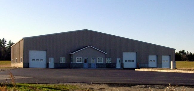
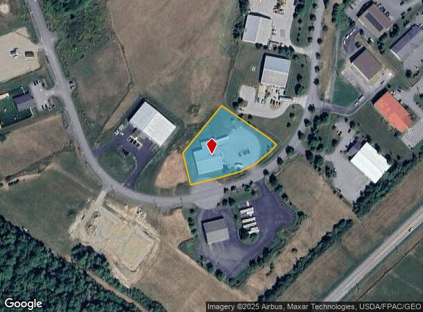
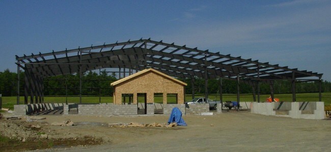
Property Record
68 Carey Dr, Hampden, ME 04444
NEARBY LISTINGS FOR SALE OR LEASE
Property Detail
68 Carey Dr
HAMN-000010-B000000-000018
Penobscot
Multipleuses
Maine
X
18
23019C2118D
1.53 AC
2025
Maine North & Bangor
2025
Other Market Areas
002000
Bangor, ME
12,192 SF
DEMOGRAPHICS near 68 Carey Dr
1 mile
3 mile
5 mile
2024 Total Population
1,121
23,678
50,041
2029 Population
1,156
24,272
51,309
Pop Growth 2024-2029
+ 3.12%
+ 2.51%
+ 2.53%
Average Age
45
43
42
2024 Total Households
492
11,272
22,502
HH Growth 2024-2029
+ 3.05%
+ 2.69%
+ 2.67%
Median Household Inc
$77,365
$50,071
$55,186
Avg Household Size
2.20
2.00
2.10
2024 Avg HH Vehicles
2.00
1.00
2.00
Median Home Value
$242,592
$198,941
$210,547
Median Year Built
1979
1953
1966
Nearby Places
Map Layers
Map Styles
 Street
 Aerial
Transit
 Traffic
 Biking
Places
Listings with unknown addresses are not visible on the map
- Restaurants
- Banks
- Shops
- Fitness
- Groceries
PUBLIC TRANSPORTATION
AIRPORT
Bangor International
Drive
Walk
Distance
Bangor International
12 min
5.1 mi
Freight Ports
Searsport, ME
Drive
Walk
Distance
Searsport, ME
50 min
31.8 mi
Nearby Properties
Address
Land Use
TOTAL SIZE
Lot Size
Zoning
Address
Land Use
TOTAL SIZE
Lot Size
Zoning
466.65 AC
ADD
Address
Land Use
TOTAL SIZE
Lot Size
Zoning
186,220 SF
93.91 AC
G&SD
Address
Land Use
TOTAL SIZE
Lot Size
Zoning
609,180 SF
6.68 AC
USD
Address
Land Use
TOTAL SIZE
Lot Size
Zoning
Address
Land Use
TOTAL SIZE
Lot Size
Zoning
6.37 AC
UID
Address
Land Use
TOTAL SIZE
Lot Size
Zoning
243,694 SF
2.95 AC
G&ISD
Address
Land Use
TOTAL SIZE
Lot Size
Zoning
54,122 SF
82.18 AC
12 - R
Address
Land Use
TOTAL SIZE
Lot Size
Zoning
87,750 SF
ADD
Address
Land Use
TOTAL SIZE
Lot Size
Zoning
400 SF
3.44 AC
WDD
Address
Land Use
TOTAL SIZE
Lot Size
Zoning
100,800 SF
1.34 AC
DDD
Address
Land Use
TOTAL SIZE
Lot Size
Zoning
12,950 SF
23.39 AC
31 - I
Address
Land Use
TOTAL SIZE
Lot Size
Zoning
168,615 SF
19.44 AC
MDR-1
Address
Land Use
TOTAL SIZE
Lot Size
Zoning
38 AC
G&ISD
Address
Land Use
TOTAL SIZE
Lot Size
Zoning
Address
Land Use
TOTAL SIZE
Lot Size
Zoning
115,044 SF
13.30 AC
G&ISD
Address
Land Use
TOTAL SIZE
Lot Size
Zoning
184,000 SF
16.43 AC
31 - I
Address
Land Use
TOTAL SIZE
Lot Size
Zoning
110,031 SF
3.81 AC
GC&S
Address
Land Use
TOTAL SIZE
Lot Size
Zoning
119,930 SF
9.50 AC
S&PS
Address
Land Use
TOTAL SIZE
Lot Size
Zoning
144,000 SF
111.04 AC
32 - I
Address
Land Use
TOTAL SIZE
Lot Size
Zoning
109,507 SF
1.96 AC
G&ISD
Address
Land Use
TOTAL SIZE
Lot Size
Zoning
7 AC
WDD
Address
Land Use
TOTAL SIZE
Lot Size
Zoning
43.96 AC
Address
Land Use
TOTAL SIZE
Lot Size
Zoning
32,570 SF
1.38 AC
G&ISD
Address
Land Use
TOTAL SIZE
Lot Size
Zoning
61,870 SF
9.20 AC
12 - R
Address
Land Use
TOTAL SIZE
Lot Size
Zoning
69,703 SF
7.92 AC
USD
Address
Land Use
TOTAL SIZE
Lot Size
Zoning
28.15 AC
GB
Address
Land Use
TOTAL SIZE
Lot Size
Zoning
96,178 SF
10.63 AC
GB
Address
Land Use
TOTAL SIZE
Lot Size
Zoning
55,514 SF
1.86 AC
G&ISD
Address
Land Use
TOTAL SIZE
Lot Size
Zoning
56,910 SF
15 AC
G&ISD
Address
Land Use
TOTAL SIZE
Lot Size
Zoning
33,608 SF
18.10 AC
G&ISD
The World's #1 Commercial Real Estate Marketplace
Connect with us
© 2026 CoStar Group
The information above has been obtained from sources believed reliable. While we do not doubt its accuracy we have not verified it and make no guarantee, warranty or representation about it. It is your responsibility to independently confirm its accuracy and completeness. Any projections, opinions, assumptions, or estimates used are for example only and do not represent the current or future performance of the property. The value of this transaction to you depends on tax and other factors which should be evaluated by your tax, financial, and legal advisors. You and your advisors should conduct a careful, independent investigation of the property to determine to your satisfaction the suitability of the property for your needs.