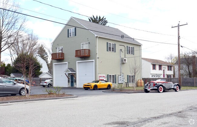
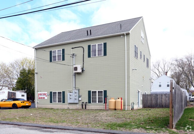
Property Record
68 Douglas Rd, Ashland, MA 01721

Property Detail
68 Douglas Rd
Commercialofficeresidentialmixeduse
MIDDLESEX
30
Massachusetts
B and X Area of moderate flood hazard, usually the area between the limits of the 100-year and 500-year floods.
0.46 AC
2025
Hopkinton/Holliston
2025
Boston
385204
Boston-Cambridge-Newton, MA-NH
2,538 SF
ASHL-000016-000143
NEARBY LISTINGS FOR SALE OR LEASE
-
-
-
No Photo
-
-
-
-
-
View all Ashland listings for sale on LoopNet.com
DEMOGRAPHICS near 68 Douglas Rd
1 mile
3 mile
5 mile
2025 Total Population
7,507
71,984
143,946
2030 Population
7,709
75,201
150,046
Pop Growth 2025-2030
+ 2.69%
+ 4.47%
+ 4.24%
Average Age
39
40
41
2025 Total Households
2,640
27,358
55,046
HH Growth 2025-2030
+ 2.88%
+ 4.57%
+ 4.35%
Median Household Inc
$98,316
$101,269
$117,085
Avg Household Size
2.70
2.50
2.50
2025 Avg HH Vehicles
2.00
2.00
2.00
Median Home Value
$594,663
$673,829
$722,523
Median Year Built
1962
1970
1969
Nearby Places
Map Layers
Map Styles
 Street
 Aerial
Transit
 Traffic
 Biking
Places
Listings with unknown addresses are not visible on the map
- Restaurants
- Banks
- Shops
- Fitness
- Groceries
PUBLIC TRANSPORTATION
COMMUTER RAIL
Drive
Walk
Distance
3 min
1.4 mi
Framingham (Framingham/Worcester Line - Massachusetts Bay Transportation Authority Commuter Rail (Purple Line))
Drive
Walk
Distance
Framingham (Framingham/Worcester Line - Massachusetts Bay Transportation Authority Commuter Rail (Purple Line))
3 min
1.4 mi
AIRPORT
General Edward Lawrence Logan International
Drive
Walk
Distance
General Edward Lawrence Logan International
41 min
26.2 mi
Worcester Regional
Drive
Walk
Distance
Worcester Regional
49 min
27.6 mi
Freight Ports
Port of Boston
Drive
Walk
Distance
Port of Boston
39 min
24.5 mi
SALE & LEASE HISTORY
LISTING DATE
SALE/LEASE

Nov 17, 2016
For Sale
Nearby Properties
Address
Land Use
TOTAL SIZE
Lot Size
Zoning
Address
Land Use
TOTAL SIZE
Lot Size
Zoning
478,440 SF
11.97 AC
B
Address
Land Use
TOTAL SIZE
Lot Size
Zoning
94,545 SF
11.70 AC
RSA
Address
Land Use
TOTAL SIZE
Lot Size
Zoning
340,840 SF
4.25 AC
B
Address
Land Use
TOTAL SIZE
Lot Size
Zoning
137,000 SF
18.96 AC
R1
Address
Land Use
TOTAL SIZE
Lot Size
Zoning
493,918 SF
28.90 AC
R1
Address
Land Use
TOTAL SIZE
Lot Size
Zoning
315,055 SF
40.38 AC
G
Address
Land Use
TOTAL SIZE
Lot Size
Zoning
20,704 SF
13.36 AC
PCD
Address
Land Use
TOTAL SIZE
Lot Size
Zoning
264,247 SF
6.09 AC
M1
Address
Land Use
TOTAL SIZE
Lot Size
Zoning
273,474 SF
7.46 AC
B
Address
Land Use
TOTAL SIZE
Lot Size
Zoning
207,522 SF
10.11 AC
B
Address
Land Use
TOTAL SIZE
Lot Size
Zoning
244,033 SF
25.75 AC
R1
Address
Land Use
TOTAL SIZE
Lot Size
Zoning
199,320 SF
16.65 AC
RSA
Address
Land Use
TOTAL SIZE
Lot Size
Zoning
108.84 AC
M
Address
Land Use
TOTAL SIZE
Lot Size
Zoning
372,275 SF
3.05 AC
CB
Address
Land Use
TOTAL SIZE
Lot Size
Zoning
139,356 SF
52 AC
30
Address
Land Use
TOTAL SIZE
Lot Size
Zoning
251,366 SF
14.42 AC
G
Address
Land Use
TOTAL SIZE
Lot Size
Zoning
231,897 SF
7.90 AC
B
Address
Land Use
TOTAL SIZE
Lot Size
Zoning
3.02 AC
CB
Address
Land Use
TOTAL SIZE
Lot Size
Zoning
112,000 SF
18.48 AC
R1
Address
Land Use
TOTAL SIZE
Lot Size
Zoning
112,000 SF
15.11 AC
G
Address
Land Use
TOTAL SIZE
Lot Size
Zoning
150,636 SF
30.34 AC
GE
Address
Land Use
TOTAL SIZE
Lot Size
Zoning
140,695 SF
2.52 AC
G
Address
Land Use
TOTAL SIZE
Lot Size
Zoning
135,535 SF
16.01 AC
B
Address
Land Use
TOTAL SIZE
Lot Size
Zoning
91,461 SF
22.63 AC
R1
Address
Land Use
TOTAL SIZE
Lot Size
Zoning
154,724 SF
39.70 AC
R3
Address
Land Use
TOTAL SIZE
Lot Size
Zoning
39,840 SF
17.20 AC
G
Address
Land Use
TOTAL SIZE
Lot Size
Zoning
61,866 SF
9.40 AC
G
Address
Land Use
TOTAL SIZE
Lot Size
Zoning
135,542 SF
6.39 AC
B
Address
Land Use
TOTAL SIZE
Lot Size
Zoning
117,332 SF
3.02 AC
CB
Address
Land Use
TOTAL SIZE
Lot Size
Zoning
35,080 SF
8.29 AC
G
The World's #1 Commercial Real Estate Marketplace
Connect with us
© 2026 CoStar Group
The information above has been obtained from sources believed reliable. While we do not doubt its accuracy we have not verified it and make no guarantee, warranty or representation about it. It is your responsibility to independently confirm its accuracy and completeness. Any projections, opinions, assumptions, or estimates used are for example only and do not represent the current or future performance of the property. The value of this transaction to you depends on tax and other factors which should be evaluated by your tax, financial, and legal advisors. You and your advisors should conduct a careful, independent investigation of the property to determine to your satisfaction the suitability of the property for your needs.