Property Record
68 Nicolettas Way, Mashpee, MA 02649
NEARBY LISTINGS FOR SALE OR LEASE
-
-
View all Mashpee listings for sale on LoopNet.com
Property Detail
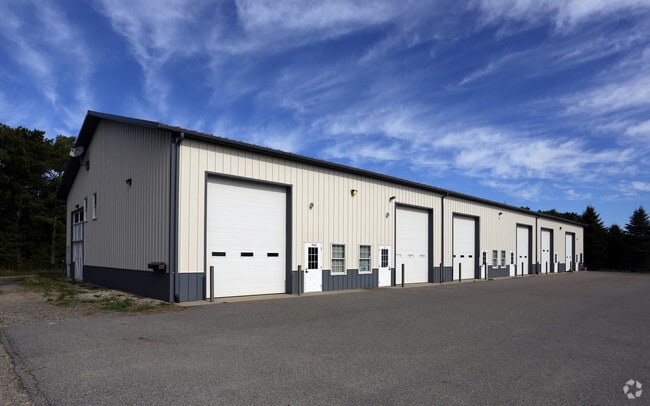
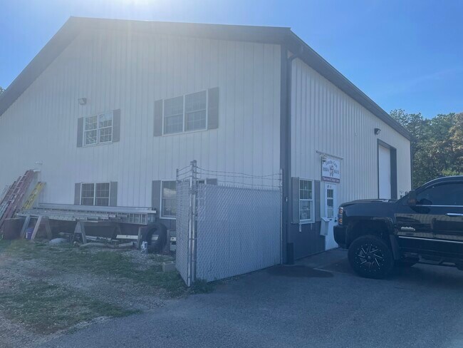
68 Nicolettas Way
Commercialcondominium
Barnstable
X
Massachusetts
25001C0538J
i
2025
Cape Cod
2025
Other Market Areas
015002
Barnstable Town, MA
2,464 SF
MASH-000026-000019-K000000
DEMOGRAPHICS near 68 Nicolettas Way
1 Mile
3 Mile
5 Mile
2024 Total Population
493
16,757
36,427
2029 Population
500
16,811
36,620
Pop Growth 2024-2029
+ 1.42%
+ 0.32%
+ 0.53%
Average Age
47
46
47
2024 Total Households
213
6,954
14,807
HH Growth 2024-2029
+ 0.94%
+ 0.22%
+ 0.36%
Median Household Inc
$66,750
$87,414
$94,215
Avg Household Size
2.20
2.40
2.40
2024 Avg HH Vehicles
2.00
2.00
2.00
Median Home Value
$417,073
$440,633
$461,242
Median Year Built
1985
1986
1985
Nearby Places
Map Layers
Map Styles
 Street
 Aerial
- Restaurants
- Banks
- Shops
- Fitness
- Groceries
PUBLIC TRANSPORTATION
AIRPORT
Martha's Vineyard
DRIVE
WALK
Distance
Martha's Vineyard
93 min
30.4 mi
Freight Ports
Port of New Bedford Harbor
DRIVE
WALK
Distance
Port of New Bedford Harbor
63 min
42.2 mi
SALE & LEASE HISTORY
LISTING DATE
SALE/LEASE

Oct 18, 2018
For Sale
Oct 17, 2018
For Sale
Jun 28, 2021
For Sale
Jul 29, 2021
For Sale
Jan 25, 2023
For Sale
Nearby Properties
Address
Land Use
TOTAL SIZE
Lot Size
Zoning
Address
Land Use
TOTAL SIZE
Lot Size
Zoning
12,713 SF
29.28 AC
C1
Address
Land Use
TOTAL SIZE
Lot Size
Zoning
181,756 SF
135.43 AC
R5
Address
Land Use
TOTAL SIZE
Lot Size
Zoning
9 AC
C1
Address
Land Use
TOTAL SIZE
Lot Size
Zoning
2,295.68 AC
BUSINE
Address
Land Use
TOTAL SIZE
Lot Size
Zoning
15.10 AC
C1
Address
Land Use
TOTAL SIZE
Lot Size
Zoning
24.40 AC
R3
Address
Land Use
TOTAL SIZE
Lot Size
Zoning
73.40 AC
R-2
Address
Land Use
TOTAL SIZE
Lot Size
Zoning
65,930 SF
3.97 AC
C1
Address
Land Use
TOTAL SIZE
Lot Size
Zoning
47.35 AC
R-2
Address
Land Use
TOTAL SIZE
Lot Size
Zoning
24.50 AC
C2
Address
Land Use
TOTAL SIZE
Lot Size
Zoning
27.80 AC
R3
Address
Land Use
TOTAL SIZE
Lot Size
Zoning
13.30 AC
I1
Address
Land Use
TOTAL SIZE
Lot Size
Zoning
8,910 SF
31.84 AC
R5
Address
Land Use
TOTAL SIZE
Lot Size
Zoning
Address
Land Use
TOTAL SIZE
Lot Size
Zoning
7,241 SF
209.72 AC
GD
Address
Land Use
TOTAL SIZE
Lot Size
Zoning
229.61 AC
R3
Address
Land Use
TOTAL SIZE
Lot Size
Zoning
33.20 AC
R5
Address
Land Use
TOTAL SIZE
Lot Size
Zoning
21,396 SF
1.90 AC
C1
Address
Land Use
TOTAL SIZE
Lot Size
Zoning
36,419 SF
7.29 AC
R3
Address
Land Use
TOTAL SIZE
Lot Size
Zoning
183.73 AC
R5
Address
Land Use
TOTAL SIZE
Lot Size
Zoning
8 AC
R5
Address
Land Use
TOTAL SIZE
Lot Size
Zoning
65.40 AC
R5
Address
Land Use
TOTAL SIZE
Lot Size
Zoning
9 AC
C1
Address
Land Use
TOTAL SIZE
Lot Size
Zoning
96,760 SF
3.57 AC
R5
Address
Land Use
TOTAL SIZE
Lot Size
Zoning
5.48 AC
R3
Address
Land Use
TOTAL SIZE
Lot Size
Zoning
136.85 AC
R-2
Address
Land Use
TOTAL SIZE
Lot Size
Zoning
13.20 AC
C1
Address
Land Use
TOTAL SIZE
Lot Size
Zoning
46.15 AC
R
Address
Land Use
TOTAL SIZE
Lot Size
Zoning
45,376 SF
4.09 AC
R5
Address
Land Use
TOTAL SIZE
Lot Size
Zoning
3,000 SF
53.30 AC
R5
The World's #1 Commercial Real Estate Marketplace
Connect with us
© 2025 CoStar Group
The information above has been obtained from sources believed reliable. While we do not doubt its accuracy we have not verified it and make no guarantee, warranty or representation about it. It is your responsibility to independently confirm its accuracy and completeness. Any projections, opinions, assumptions, or estimates used are for example only and do not represent the current or future performance of the property. The value of this transaction to you depends on tax and other factors which should be evaluated by your tax, financial, and legal advisors. You and your advisors should conduct a careful, independent investigation of the property to determine to your satisfaction the suitability of the property for your needs.