Property Record
680 Cross Pointe Rd, Columbus, OH 43230
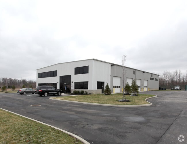
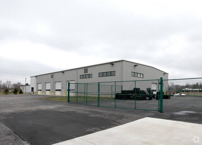
Property Detail
680 Cross Pointe Rd
Columbus, OH
CROSS POINTE RD CROSSROADS COMMERCE CNTR PT LOT 8=3.128 ACRES
025-012072
FRANKLIN
Storemultistory
Ohio
B and X Area of moderate flood hazard, usually the area between the limits of the 100-year and 500-year floods.
8 3
2024
1.87 AC
2025
Airport
007303
Columbus
13,200 SF
NEARBY LISTINGS FOR SALE OR LEASE
DEMOGRAPHICS near 680 Cross Pointe Rd
1 mile
3 mile
5 mile
2025 Total Population
4,510
66,324
206,091
2030 Population
4,640
68,043
211,905
Pop Growth 2025-2030
+ 2.88%
+ 2.59%
+ 2.82%
Average Age
38
39
38
2025 Total Households
1,692
25,978
81,603
HH Growth 2025-2030
+ 2.96%
+ 2.72%
+ 2.89%
Median Household Inc
$104,286
$88,182
$73,049
Avg Household Size
2.60
2.50
2.50
2025 Avg HH Vehicles
2.00
2.00
2.00
Median Home Value
$393,232
$315,433
$287,750
Median Year Built
1996
1993
1986
Nearby Places
Map Layers
Map Styles
 Street
 Aerial
Layers
 Traffic
 Biking
Places
Listings with unknown addresses are not visible on the map
- Restaurants
- Banks
- Shops
- Fitness
- Groceries
PUBLIC TRANSPORTATION
AIRPORT
John Glenn Columbus International
Drive
Walk
Distance
John Glenn Columbus International
12 min
5.1 mi
Rickenbacker International
Drive
Walk
Distance
Rickenbacker International
25 min
16.0 mi
Nearby Properties
Address
Land Use
TOTAL SIZE
Lot Size
Zoning
Address
Land Use
TOTAL SIZE
Lot Size
Zoning
Address
Land Use
TOTAL SIZE
Lot Size
Zoning
761,542 SF
21.30 AC
Address
Land Use
TOTAL SIZE
Lot Size
Zoning
208,472 SF
1.45 AC
Address
Land Use
TOTAL SIZE
Lot Size
Zoning
329,049 SF
38.53 AC
Address
Land Use
TOTAL SIZE
Lot Size
Zoning
164,095 SF
33.71 AC
Address
Land Use
TOTAL SIZE
Lot Size
Zoning
147,649 SF
5.15 AC
Address
Land Use
TOTAL SIZE
Lot Size
Zoning
122,526 SF
27 AC
Address
Land Use
TOTAL SIZE
Lot Size
Zoning
514,341 SF
46.79 AC
Address
Land Use
TOTAL SIZE
Lot Size
Zoning
282,035 SF
29.29 AC
Address
Land Use
TOTAL SIZE
Lot Size
Zoning
60,056 SF
0.22 AC
Address
Land Use
TOTAL SIZE
Lot Size
Zoning
137,136 SF
69.71 AC
Address
Land Use
TOTAL SIZE
Lot Size
Zoning
464,796 SF
7.33 AC
Address
Land Use
TOTAL SIZE
Lot Size
Zoning
166,628 SF
9.98 AC
Address
Land Use
TOTAL SIZE
Lot Size
Zoning
253,893 SF
12.57 AC
Address
Land Use
TOTAL SIZE
Lot Size
Zoning
171,366 SF
28.27 AC
Address
Land Use
TOTAL SIZE
Lot Size
Zoning
122,390 SF
7.77 AC
Address
Land Use
TOTAL SIZE
Lot Size
Zoning
170,209 SF
15.03 AC
Address
Land Use
TOTAL SIZE
Lot Size
Zoning
142,542 SF
6.55 AC
Address
Land Use
TOTAL SIZE
Lot Size
Zoning
142,542 SF
3.95 AC
Address
Land Use
TOTAL SIZE
Lot Size
Zoning
158,325 SF
34.39 AC
Address
Land Use
TOTAL SIZE
Lot Size
Zoning
173,727 SF
38.26 AC
Address
Land Use
TOTAL SIZE
Lot Size
Zoning
82,450 SF
28.27 AC
Address
Land Use
TOTAL SIZE
Lot Size
Zoning
267,596 SF
5.76 AC
Address
Land Use
TOTAL SIZE
Lot Size
Zoning
264,250 SF
10.31 AC
Address
Land Use
TOTAL SIZE
Lot Size
Zoning
511,125 SF
24.90 AC
Address
Land Use
TOTAL SIZE
Lot Size
Zoning
25,512 SF
18.89 AC
Address
Land Use
TOTAL SIZE
Lot Size
Zoning
176,140 SF
9.24 AC
Address
Land Use
TOTAL SIZE
Lot Size
Zoning
209,585 SF
24.94 AC
Address
Land Use
TOTAL SIZE
Lot Size
Zoning
511,625 SF
22.42 AC
Address
Land Use
TOTAL SIZE
Lot Size
Zoning
88,963 SF
14 AC
The World's #1 Commercial Real Estate Marketplace
Connect with us
© 2026 CoStar Group
The information above has been obtained from sources believed reliable. While we do not doubt its accuracy we have not verified it and make no guarantee, warranty or representation about it. It is your responsibility to independently confirm its accuracy and completeness. Any projections, opinions, assumptions, or estimates used are for example only and do not represent the current or future performance of the property. The value of this transaction to you depends on tax and other factors which should be evaluated by your tax, financial, and legal advisors. You and your advisors should conduct a careful, independent investigation of the property to determine to your satisfaction the suitability of the property for your needs.