Property Record
680 Derrick Ave, Mendota, CA 93640
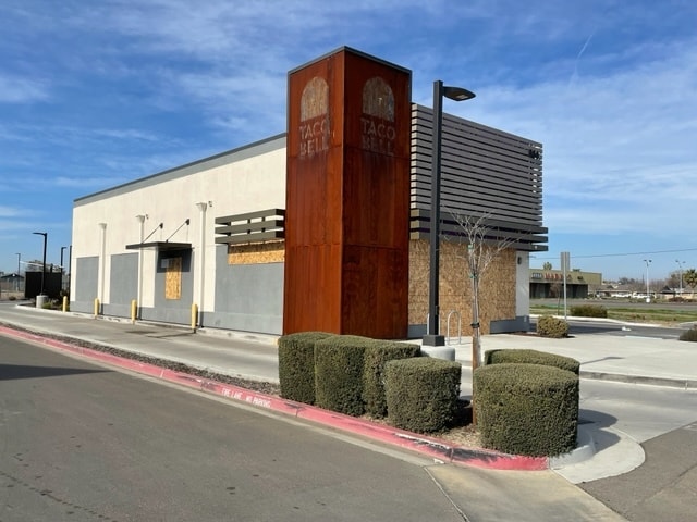

Property Detail
680 Derrick Ave
012-264-22
PAR IN E3/4 OF PAR 3 OF P/M 14-01 BK72 PG76-77
Restaurantbuilding
Fresno
C2
California
B and X Area of moderate flood hazard, usually the area between the limits of the 100-year and 500-year floods.
0.81 AC
2025
W Outlying Fresno Cnty
2025
Fresno
008303
Fresno, CA
2,100 SF
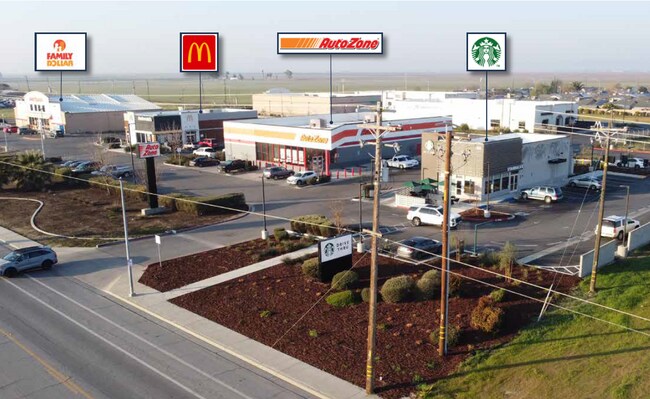
NEARBY LISTINGS FOR SALE OR LEASE
-
-
View all Mendota listings for sale on LoopNet.com
DEMOGRAPHICS near 680 Derrick Ave
1 mile
3 mile
5 mile
2025 Total Population
9,520
12,521
13,044
2030 Population
9,486
12,587
13,121
Pop Growth 2025-2030
(0.36%)
+ 0.53%
+ 0.59%
Average Age
32
31
32
2025 Total Households
2,143
2,805
2,902
HH Growth 2025-2030
(0.51%)
+ 0.50%
+ 0.55%
Median Household Inc
$44,568
$43,882
$43,575
Avg Household Size
4.30
4.30
4.30
2025 Avg HH Vehicles
2.00
2.00
2.00
Median Home Value
$258,891
$266,460
$269,081
Median Year Built
1992
1993
1992
Nearby Places
Map Layers
Map Styles
 Street
 Aerial
Transit
 Traffic
 Biking
Places
Listings with unknown addresses are not visible on the map
- Restaurants
- Banks
- Shops
- Fitness
- Groceries
SALE & LEASE HISTORY
LISTING DATE
SALE/LEASE

Feb 07, 2025
For Sale
Nearby Properties
Address
Land Use
TOTAL SIZE
Lot Size
Zoning
Address
Land Use
TOTAL SIZE
Lot Size
Zoning
621.02 AC
AE20
Address
Land Use
TOTAL SIZE
Lot Size
Zoning
104,315 SF
5.89 AC
R3
Address
Land Use
TOTAL SIZE
Lot Size
Zoning
105,634 SF
6.32 AC
R3
Address
Land Use
TOTAL SIZE
Lot Size
Zoning
74,270 SF
6.14 AC
R2
Address
Land Use
TOTAL SIZE
Lot Size
Zoning
79,430 SF
7.95 AC
R3
Address
Land Use
TOTAL SIZE
Lot Size
Zoning
9,142 SF
2.05 AC
R3
Address
Land Use
TOTAL SIZE
Lot Size
Zoning
91,040 SF
13.34 AC
M1
Address
Land Use
TOTAL SIZE
Lot Size
Zoning
29,718 SF
3.74 AC
R3
Address
Land Use
TOTAL SIZE
Lot Size
Zoning
10,080 SF
2.37 AC
C2
Address
Land Use
TOTAL SIZE
Lot Size
Zoning
48,876 SF
3.91 AC
M1
Address
Land Use
TOTAL SIZE
Lot Size
Zoning
10,080 SF
1.07 AC
C3
Address
Land Use
TOTAL SIZE
Lot Size
Zoning
70,186 SF
8.06 AC
M1
Address
Land Use
TOTAL SIZE
Lot Size
Zoning
12,270 SF
0.86 AC
C3
Address
Land Use
TOTAL SIZE
Lot Size
Zoning
41,508 SF
2.97 AC
R2
Address
Land Use
TOTAL SIZE
Lot Size
Zoning
8,320 SF
1.11 AC
C
Address
Land Use
TOTAL SIZE
Lot Size
Zoning
10,000 SF
1.03 AC
C3
Address
Land Use
TOTAL SIZE
Lot Size
Zoning
912 SF
291.28 AC
AE20
Address
Land Use
TOTAL SIZE
Lot Size
Zoning
31,630 SF
3.09 AC
R1
Address
Land Use
TOTAL SIZE
Lot Size
Zoning
14,700 SF
1.97 AC
R3
Address
Land Use
TOTAL SIZE
Lot Size
Zoning
24,332 SF
2.57 AC
C3
Address
Land Use
TOTAL SIZE
Lot Size
Zoning
7,360 SF
1.15 AC
C2
Address
Land Use
TOTAL SIZE
Lot Size
Zoning
0.60 AC
C3
Address
Land Use
TOTAL SIZE
Lot Size
Zoning
4,848 SF
0.86 AC
C3*TWR
Address
Land Use
TOTAL SIZE
Lot Size
Zoning
2,200 SF
0.66 AC
C3
Address
Land Use
TOTAL SIZE
Lot Size
Zoning
3,008 SF
1.61 AC
C3
Address
Land Use
TOTAL SIZE
Lot Size
Zoning
27,584 SF
1.48 AC
C2
Address
Land Use
TOTAL SIZE
Lot Size
Zoning
320 SF
0.34 AC
R1
The World's #1 Commercial Real Estate Marketplace
Connect with us
© 2026 CoStar Group
The information above has been obtained from sources believed reliable. While we do not doubt its accuracy we have not verified it and make no guarantee, warranty or representation about it. It is your responsibility to independently confirm its accuracy and completeness. Any projections, opinions, assumptions, or estimates used are for example only and do not represent the current or future performance of the property. The value of this transaction to you depends on tax and other factors which should be evaluated by your tax, financial, and legal advisors. You and your advisors should conduct a careful, independent investigation of the property to determine to your satisfaction the suitability of the property for your needs.