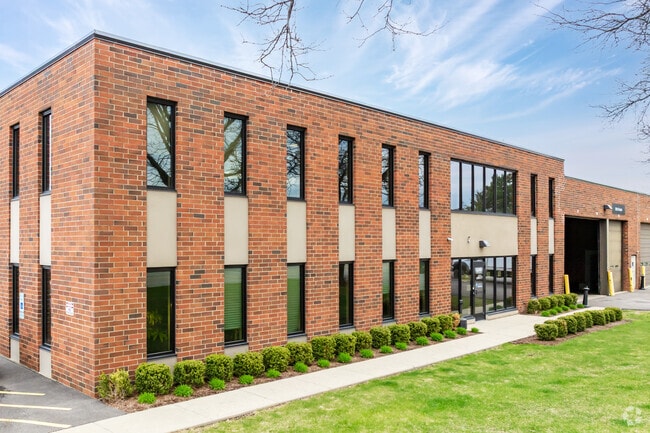
Property Record
680 Industrial Dr, Cary, IL 60013
Current Lease Availabilities
Property Detail
680 Industrial Dr
Chicago-Naperville-Elgin, IL-IN
DOC 2020R0057271 LT 7 CARY INDUSTRIAL CENTER
19-12-352-002
McHenry
Industrialgeneral
Illinois
B and X Area of moderate flood hazard, usually the area between the limits of the 100-year and 500-year floods.
7
2024
1.27 AC
2024
McHenry County
871312
Chicago
NEARBY LISTINGS FOR SALE OR LEASE
DEMOGRAPHICS near 680 Industrial Dr
1 mile
3 mile
5 mile
2025 Total Population
9,876
37,831
111,010
2030 Population
10,021
38,301
112,163
Pop Growth 2025-2030
+ 1.47%
+ 1.24%
+ 1.04%
Average Age
41
41
41
2025 Total Households
3,550
13,868
41,362
HH Growth 2025-2030
+ 1.58%
+ 1.36%
+ 1.10%
Median Household Inc
$100,844
$111,854
$106,595
Avg Household Size
2.80
2.70
2.60
2025 Avg HH Vehicles
2.00
2.00
2.00
Median Home Value
$287,136
$324,730
$307,894
Median Year Built
1979
1982
1984
Nearby Places
Map Layers
Map Styles
 Street
 Aerial
Layers
 Traffic
 Biking
Places
Listings with unknown addresses are not visible on the map
- Restaurants
- Banks
- Shops
- Fitness
- Groceries
PUBLIC TRANSPORTATION
COMMUTER RAIL
Cary Station (Union Pacific Northwest Line - Northeast Illinois Regional Commuter Railroad (Metra))
Drive
Walk
Distance
Cary Station (Union Pacific Northwest Line - Northeast Illinois Regional Commuter Railroad (Metra))
2 min
1.1 mi
Fox River Grove Station (Union Pacific Northwest Line - Northeast Illinois Regional Commuter Railroad (Metra))
Drive
Walk
Distance
Fox River Grove Station (Union Pacific Northwest Line - Northeast Illinois Regional Commuter Railroad (Metra))
5 min
2.6 mi
AIRPORT
Chicago O'Hare International
Drive
Walk
Distance
Chicago O'Hare International
46 min
31.0 mi
Freight Ports
Port Milwaukee
Drive
Walk
Distance
Port Milwaukee
97 min
72.0 mi
Nearby Properties
Address
Land Use
TOTAL SIZE
Lot Size
Zoning
Address
Land Use
TOTAL SIZE
Lot Size
Zoning
Address
Land Use
TOTAL SIZE
Lot Size
Zoning
28.48 AC
Address
Land Use
TOTAL SIZE
Lot Size
Zoning
449,650 SF
25 AC
Address
Land Use
TOTAL SIZE
Lot Size
Zoning
15.94 AC
Address
Land Use
TOTAL SIZE
Lot Size
Zoning
393,554 SF
83.76 AC
Address
Land Use
TOTAL SIZE
Lot Size
Zoning
64,269 SF
5.08 AC
Address
Land Use
TOTAL SIZE
Lot Size
Zoning
20.81 AC
Address
Land Use
TOTAL SIZE
Lot Size
Zoning
217,182 SF
22.43 AC
Address
Land Use
TOTAL SIZE
Lot Size
Zoning
71,703 SF
0.50 AC
Address
Land Use
TOTAL SIZE
Lot Size
Zoning
66,594 SF
5.22 AC
Address
Land Use
TOTAL SIZE
Lot Size
Zoning
47,164 SF
0.70 AC
Address
Land Use
TOTAL SIZE
Lot Size
Zoning
504,206 SF
11.06 AC
Address
Land Use
TOTAL SIZE
Lot Size
Zoning
51,909 SF
0.50 AC
Address
Land Use
TOTAL SIZE
Lot Size
Zoning
55,547 SF
0.60 AC
Address
Land Use
TOTAL SIZE
Lot Size
Zoning
72,173 SF
5.23 AC
Address
Land Use
TOTAL SIZE
Lot Size
Zoning
127,059 SF
16.84 AC
Address
Land Use
TOTAL SIZE
Lot Size
Zoning
122,668 SF
9.73 AC
Address
Land Use
TOTAL SIZE
Lot Size
Zoning
161,610 SF
15.03 AC
Address
Land Use
TOTAL SIZE
Lot Size
Zoning
35,452 SF
105.76 AC
Address
Land Use
TOTAL SIZE
Lot Size
Zoning
124,301 SF
8.80 AC
Address
Land Use
TOTAL SIZE
Lot Size
Zoning
30.77 AC
Address
Land Use
TOTAL SIZE
Lot Size
Zoning
141,363 SF
9 AC
Address
Land Use
TOTAL SIZE
Lot Size
Zoning
Address
Land Use
TOTAL SIZE
Lot Size
Zoning
Address
Land Use
TOTAL SIZE
Lot Size
Zoning
4.74 AC
Address
Land Use
TOTAL SIZE
Lot Size
Zoning
75,205 SF
22.94 AC
Address
Land Use
TOTAL SIZE
Lot Size
Zoning
70,243 SF
11.36 AC
Address
Land Use
TOTAL SIZE
Lot Size
Zoning
56,537 SF
4.80 AC
Address
Land Use
TOTAL SIZE
Lot Size
Zoning
118,400 SF
8 AC
The World's #1 Commercial Real Estate Marketplace
Connect with us
© 2026 CoStar Group
The information above has been obtained from sources believed reliable. While we do not doubt its accuracy we have not verified it and make no guarantee, warranty or representation about it. It is your responsibility to independently confirm its accuracy and completeness. Any projections, opinions, assumptions, or estimates used are for example only and do not represent the current or future performance of the property. The value of this transaction to you depends on tax and other factors which should be evaluated by your tax, financial, and legal advisors. You and your advisors should conduct a careful, independent investigation of the property to determine to your satisfaction the suitability of the property for your needs.