Property Record
680 Route 739, Hawley, PA 18428


NEARBY LISTINGS FOR SALE OR LEASE
Property Detail
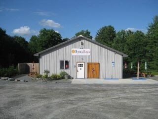
680 Route 739
032881
Estates/Loretta Bauman
Agriculturalland
12.03 AC ACT 319 HOUSE & RESTAURANT
A
Pike
42103C0285C
Pennsylvania
2024
12.03 AC
2025
Pike County
950504
Northern New Jersey
3,480 SF
Newark, NJ-PA
DEMOGRAPHICS near 680 Route 739
1 Mile
3 Mile
5 Mile
2024 Total Population
1,268
4,896
9,897
2029 Population
1,462
5,503
10,720
Pop Growth 2024-2029
+ 15.30%
+ 12.40%
+ 8.32%
Average Age
47
47
46
2024 Total Households
523
2,033
3,942
HH Growth 2024-2029
+ 15.11%
+ 12.25%
+ 8.35%
Median Household Inc
$70,609
$70,224
$70,734
Avg Household Size
2.40
2.30
2.40
2024 Avg HH Vehicles
2.00
2.00
2.00
Median Home Value
$181,654
$224,583
$231,905
Median Year Built
1986
1985
1985
Nearby Places
Map Layers
Map Styles
 Street
 Aerial
- Restaurants
- Banks
- Shops
- Fitness
- Groceries
SALE & LEASE HISTORY
LISTING DATE
SALE/LEASE

Sep 24, 2016
For Sale
Mar 26, 2018
For Sale
Jul 09, 2018
For Sale
Nearby Properties
Address
Land Use
TOTAL SIZE
Lot Size
Zoning
Address
Land Use
TOTAL SIZE
Lot Size
Zoning
55,760 SF
35.82 AC
Address
Land Use
TOTAL SIZE
Lot Size
Zoning
13,072 SF
486 AC
Address
Land Use
TOTAL SIZE
Lot Size
Zoning
41,400 SF
4.47 AC
Address
Land Use
TOTAL SIZE
Lot Size
Zoning
512 SF
1.29 AC
Address
Land Use
TOTAL SIZE
Lot Size
Zoning
7,416 SF
4.43 AC
Address
Land Use
TOTAL SIZE
Lot Size
Zoning
8,166 SF
1.34 AC
Address
Land Use
TOTAL SIZE
Lot Size
Zoning
10,546 SF
4.38 AC
Address
Land Use
TOTAL SIZE
Lot Size
Zoning
9,704 SF
5.01 AC
Address
Land Use
TOTAL SIZE
Lot Size
Zoning
6,912 SF
1.80 AC
Address
Land Use
TOTAL SIZE
Lot Size
Zoning
9,600 SF
2.25 AC
Address
Land Use
TOTAL SIZE
Lot Size
Zoning
4,608 SF
4.19 AC
Address
Land Use
TOTAL SIZE
Lot Size
Zoning
18,054 SF
3 AC
Address
Land Use
TOTAL SIZE
Lot Size
Zoning
26.79 AC
Address
Land Use
TOTAL SIZE
Lot Size
Zoning
4,457 SF
4.47 AC
Address
Land Use
TOTAL SIZE
Lot Size
Zoning
8,427 SF
50.63 AC
Address
Land Use
TOTAL SIZE
Lot Size
Zoning
10,974 SF
3.58 AC
Address
Land Use
TOTAL SIZE
Lot Size
Zoning
12,920 SF
4.64 AC
Address
Land Use
TOTAL SIZE
Lot Size
Zoning
6,835 SF
5.04 AC
Address
Land Use
TOTAL SIZE
Lot Size
Zoning
8,537 SF
3.25 AC
Address
Land Use
TOTAL SIZE
Lot Size
Zoning
6,918 SF
2.11 AC
Address
Land Use
TOTAL SIZE
Lot Size
Zoning
0.11 AC
Address
Land Use
TOTAL SIZE
Lot Size
Zoning
0.05 AC
Address
Land Use
TOTAL SIZE
Lot Size
Zoning
5,760 SF
1.13 AC
Address
Land Use
TOTAL SIZE
Lot Size
Zoning
6,917 SF
1.59 AC
Address
Land Use
TOTAL SIZE
Lot Size
Zoning
6,990 SF
2.29 AC
Address
Land Use
TOTAL SIZE
Lot Size
Zoning
450.51 AC
Address
Land Use
TOTAL SIZE
Lot Size
Zoning
7,788 SF
1.92 AC
Address
Land Use
TOTAL SIZE
Lot Size
Zoning
3,803 SF
1.93 AC
Address
Land Use
TOTAL SIZE
Lot Size
Zoning
3,570 SF
4.67 AC
The World's #1 Commercial Real Estate Marketplace
Connect with us
© 2025 CoStar Group
The information above has been obtained from sources believed reliable. While we do not doubt its accuracy we have not verified it and make no guarantee, warranty or representation about it. It is your responsibility to independently confirm its accuracy and completeness. Any projections, opinions, assumptions, or estimates used are for example only and do not represent the current or future performance of the property. The value of this transaction to you depends on tax and other factors which should be evaluated by your tax, financial, and legal advisors. You and your advisors should conduct a careful, independent investigation of the property to determine to your satisfaction the suitability of the property for your needs.