Property Record
680 W Broad St, Mineola, TX 75773
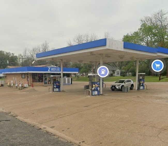

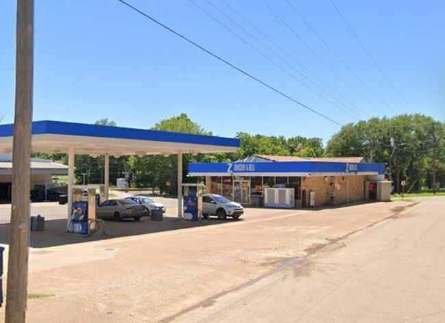
This Property Is For Sale
Property Detail
680 W Broad St
R36104
LOT 15H,15F,15M BLK 90 .3627 MINEOLA TOWNSITES
Commercialnec
Wood
B and X Area of moderate flood hazard, usually the area between the limits of the 100-year and 500-year floods.
Texas
2025
0.36 AC
2025
Texas East Area
950800
Other Market Areas
1,960 SF
NEARBY LISTINGS FOR SALE OR LEASE
DEMOGRAPHICS near 680 W Broad St
1 mile
3 mile
5 mile
2025 Total Population
2,788
7,556
11,598
2030 Population
2,989
8,058
12,369
Pop Growth 2025-2030
+ 7.21%
+ 6.64%
+ 6.65%
Average Age
41
43
44
2025 Total Households
1,043
2,937
4,505
HH Growth 2025-2030
+ 7.29%
+ 6.67%
+ 6.59%
Median Household Inc
$51,011
$53,855
$55,473
Avg Household Size
2.50
2.40
2.50
2025 Avg HH Vehicles
2.00
2.00
2.00
Median Home Value
$194,594
$229,007
$242,688
Median Year Built
1981
1985
1987
Nearby Places
Map Layers
Map Styles
 Street
 Aerial
Transit
 Traffic
 Biking
Places
Listings with unknown addresses are not visible on the map
- Restaurants
- Banks
- Shops
- Fitness
- Groceries
PUBLIC TRANSPORTATION
COMMUTER RAIL
Drive
Walk
Distance
2 min
15 min
0.8 mi
AIRPORT
Tyler Pounds Regional
Drive
Walk
Distance
Tyler Pounds Regional
35 min
26.3 mi
Nearby Properties
Address
Land Use
TOTAL SIZE
Lot Size
Zoning
Address
Land Use
TOTAL SIZE
Lot Size
Zoning
90,026 SF
25.72 AC
Address
Land Use
TOTAL SIZE
Lot Size
Zoning
138,125 SF
27.97 AC
Address
Land Use
TOTAL SIZE
Lot Size
Zoning
567 SF
605.79 AC
Address
Land Use
TOTAL SIZE
Lot Size
Zoning
68,715 SF
3.69 AC
Address
Land Use
TOTAL SIZE
Lot Size
Zoning
55,614 SF
3.49 AC
Address
Land Use
TOTAL SIZE
Lot Size
Zoning
106,466 SF
52.34 AC
Address
Land Use
TOTAL SIZE
Lot Size
Zoning
31,880 SF
12.57 AC
Address
Land Use
TOTAL SIZE
Lot Size
Zoning
2,319 SF
588.60 AC
Address
Land Use
TOTAL SIZE
Lot Size
Zoning
154,539 SF
19.19 AC
Address
Land Use
TOTAL SIZE
Lot Size
Zoning
28,248 SF
21.30 AC
Address
Land Use
TOTAL SIZE
Lot Size
Zoning
7,844 SF
62.98 AC
Address
Land Use
TOTAL SIZE
Lot Size
Zoning
6,083 SF
122.96 AC
Address
Land Use
TOTAL SIZE
Lot Size
Zoning
4,703 SF
255.77 AC
Address
Land Use
TOTAL SIZE
Lot Size
Zoning
8,675 SF
159.35 AC
Address
Land Use
TOTAL SIZE
Lot Size
Zoning
7,044 SF
1.84 AC
Address
Land Use
TOTAL SIZE
Lot Size
Zoning
15,466 SF
1.60 AC
Address
Land Use
TOTAL SIZE
Lot Size
Zoning
54,489 SF
3.19 AC
Address
Land Use
TOTAL SIZE
Lot Size
Zoning
18,150 SF
2.50 AC
Address
Land Use
TOTAL SIZE
Lot Size
Zoning
7,800 SF
243.10 AC
Address
Land Use
TOTAL SIZE
Lot Size
Zoning
18,583 SF
2.08 AC
Address
Land Use
TOTAL SIZE
Lot Size
Zoning
10,396 SF
0.69 AC
Address
Land Use
TOTAL SIZE
Lot Size
Zoning
11,405 SF
65.30 AC
Address
Land Use
TOTAL SIZE
Lot Size
Zoning
165 AC
Address
Land Use
TOTAL SIZE
Lot Size
Zoning
9,191 SF
43.33 AC
Address
Land Use
TOTAL SIZE
Lot Size
Zoning
23,642 SF
4.45 AC
Address
Land Use
TOTAL SIZE
Lot Size
Zoning
19,593 SF
2.65 AC
Address
Land Use
TOTAL SIZE
Lot Size
Zoning
24,096 SF
0.71 AC
Address
Land Use
TOTAL SIZE
Lot Size
Zoning
6,035 SF
4.41 AC
Address
Land Use
TOTAL SIZE
Lot Size
Zoning
28,602 SF
1.53 AC
Address
Land Use
TOTAL SIZE
Lot Size
Zoning
20,188 SF
0.42 AC
The World's #1 Commercial Real Estate Marketplace
Connect with us
© 2026 CoStar Group
The information above has been obtained from sources believed reliable. While we do not doubt its accuracy we have not verified it and make no guarantee, warranty or representation about it. It is your responsibility to independently confirm its accuracy and completeness. Any projections, opinions, assumptions, or estimates used are for example only and do not represent the current or future performance of the property. The value of this transaction to you depends on tax and other factors which should be evaluated by your tax, financial, and legal advisors. You and your advisors should conduct a careful, independent investigation of the property to determine to your satisfaction the suitability of the property for your needs.