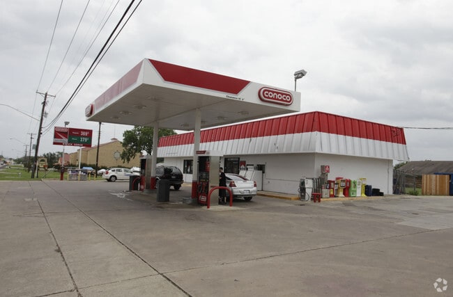
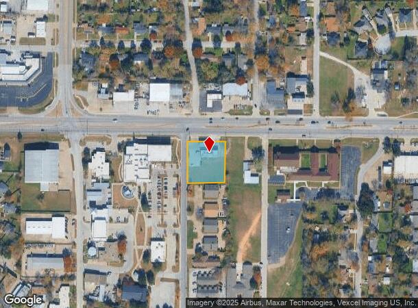
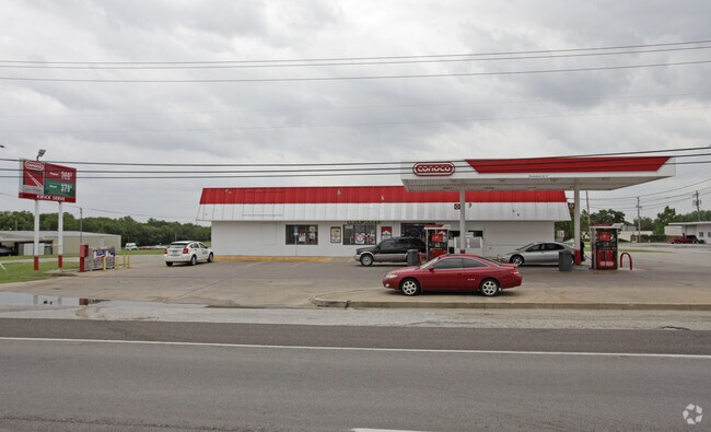
Property Record
6800 Baker Blvd, Richland Hills, TX 76118
NEARBY LISTINGS FOR SALE OR LEASE
Property Detail
6800 Baker Blvd
Dallas-Fort Worth-Arlington, TX
Matthews Resub/Lt #9 Lot
01651870
MATTHEWS RESUB/LT #9 LOT A
Commercialnec
Tarrant
X
Texas
48439C0215L
9,a
2024
0.83 AC
2025
Haltom City
113302
Dallas/Ft Worth
2,268 SF
DEMOGRAPHICS near 6800 Baker Blvd
1 Mile
3 Mile
5 Mile
2024 Total Population
8,287
84,600
263,853
2029 Population
8,698
89,104
278,660
Pop Growth 2024-2029
+ 4.96%
+ 5.32%
+ 5.61%
Average Age
39
38
37
2024 Total Households
3,022
32,192
98,796
HH Growth 2024-2029
+ 5.03%
+ 5.41%
+ 5.72%
Median Household Inc
$56,655
$59,099
$61,539
Avg Household Size
2.60
2.60
2.60
2024 Avg HH Vehicles
2.00
2.00
2.00
Median Home Value
$213,066
$228,646
$231,850
Median Year Built
1960
1974
1979
Nearby Places
Map Layers
Map Styles
 Street
 Aerial
- Restaurants
- Banks
- Shops
- Fitness
- Groceries
PUBLIC TRANSPORTATION
COMMUTER RAIL
Richland Hills (Trinity Railway Express - Dallas Area Rapid Transit (DART))
DRIVE
WALK
Distance
Richland Hills (Trinity Railway Express - Dallas Area Rapid Transit (DART))
4 min
1.9 mi
DRIVE
WALK
Distance
5 min
2.0 mi
AIRPORT
Dallas-Fort Worth International
DRIVE
WALK
Distance
Dallas-Fort Worth International
25 min
18.0 mi
Dallas Love Field
DRIVE
WALK
Distance
Dallas Love Field
36 min
26.6 mi
Nearby Properties
Address
Land Use
TOTAL SIZE
Lot Size
Zoning
Address
Land Use
TOTAL SIZE
Lot Size
Zoning
1,300,314 SF
40.15 AC
Address
Land Use
TOTAL SIZE
Lot Size
Zoning
381,000 SF
8.74 AC
Address
Land Use
TOTAL SIZE
Lot Size
Zoning
174,596 SF
11.91 AC
Address
Land Use
TOTAL SIZE
Lot Size
Zoning
231,871 SF
17.08 AC
Address
Land Use
TOTAL SIZE
Lot Size
Zoning
318,602 SF
9.90 AC
Address
Land Use
TOTAL SIZE
Lot Size
Zoning
368,751 SF
19.97 AC
Address
Land Use
TOTAL SIZE
Lot Size
Zoning
293,972 SF
17.30 AC
Address
Land Use
TOTAL SIZE
Lot Size
Zoning
237,551 SF
4.39 AC
Address
Land Use
TOTAL SIZE
Lot Size
Zoning
173,068 SF
15.55 AC
Address
Land Use
TOTAL SIZE
Lot Size
Zoning
241,064 SF
12.63 AC
Address
Land Use
TOTAL SIZE
Lot Size
Zoning
307,568 SF
13.13 AC
Address
Land Use
TOTAL SIZE
Lot Size
Zoning
232,295 SF
21.49 AC
Address
Land Use
TOTAL SIZE
Lot Size
Zoning
194,625 SF
15.07 AC
Address
Land Use
TOTAL SIZE
Lot Size
Zoning
187,236 SF
9.85 AC
Address
Land Use
TOTAL SIZE
Lot Size
Zoning
176,242 SF
11.59 AC
Address
Land Use
TOTAL SIZE
Lot Size
Zoning
526,195 SF
40.84 AC
Address
Land Use
TOTAL SIZE
Lot Size
Zoning
195,678 SF
12.24 AC
Address
Land Use
TOTAL SIZE
Lot Size
Zoning
262,233 SF
16.13 AC
Address
Land Use
TOTAL SIZE
Lot Size
Zoning
132,145 SF
12.26 AC
Address
Land Use
TOTAL SIZE
Lot Size
Zoning
199,744 SF
9.99 AC
Address
Land Use
TOTAL SIZE
Lot Size
Zoning
306,524 SF
24.92 AC
Address
Land Use
TOTAL SIZE
Lot Size
Zoning
204,948 SF
23.93 AC
Address
Land Use
TOTAL SIZE
Lot Size
Zoning
146,918 SF
3.31 AC
Address
Land Use
TOTAL SIZE
Lot Size
Zoning
141,276 SF
12.04 AC
Address
Land Use
TOTAL SIZE
Lot Size
Zoning
170,983 SF
11.42 AC
Address
Land Use
TOTAL SIZE
Lot Size
Zoning
125,838 SF
12.38 AC
Address
Land Use
TOTAL SIZE
Lot Size
Zoning
181,988 SF
8.10 AC
Address
Land Use
TOTAL SIZE
Lot Size
Zoning
185,047 SF
10 AC
Address
Land Use
TOTAL SIZE
Lot Size
Zoning
214,083 SF
19.84 AC
Address
Land Use
TOTAL SIZE
Lot Size
Zoning
106,045 SF
9.64 AC
The World's #1 Commercial Real Estate Marketplace
Connect with us
© 2025 CoStar Group
The information above has been obtained from sources believed reliable. While we do not doubt its accuracy we have not verified it and make no guarantee, warranty or representation about it. It is your responsibility to independently confirm its accuracy and completeness. Any projections, opinions, assumptions, or estimates used are for example only and do not represent the current or future performance of the property. The value of this transaction to you depends on tax and other factors which should be evaluated by your tax, financial, and legal advisors. You and your advisors should conduct a careful, independent investigation of the property to determine to your satisfaction the suitability of the property for your needs.