Property Record
6808 N Bryant Ave, Oklahoma City, OK 73121
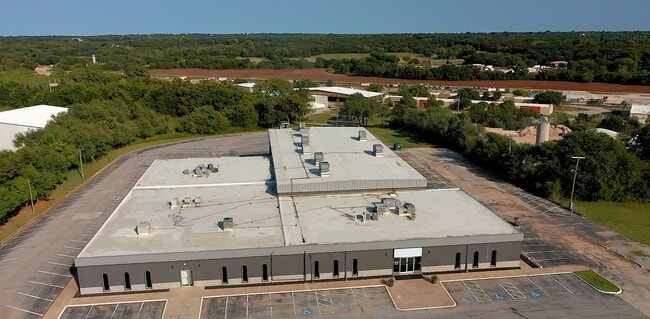

This Property Is For Sale
NEARBY LISTINGS FOR SALE OR LEASE
Property Detail
6808 N Bryant Ave
141709040
Unpltd Pt Sec 06 12N 2W
Publicschool
UNPLTD PT W2 SEC 6 12N 2W BEG 215.07FT TH NELY 925.17FT FROM SW/C SEC 6 TH NE ALONG RR/RW 2038.04FT E699.17FT SW1501.13FT SW425.37FT SW537.37FT NW348.14FT TO BEG CONT 28.335ACRS MORE OR LESS
AE
Oklahoma
40109C0190H
Oklahoma
2024
29.61 AC
2024
East Oklahoma County
106000
Oklahoma City
49,381 SF
Oklahoma City, OK
DEMOGRAPHICS near 6808 N Bryant Ave
1 Mile
3 Mile
5 Mile
2024 Total Population
334
12,649
72,089
2029 Population
336
12,953
74,628
Pop Growth 2024-2029
+ 0.60%
+ 2.40%
+ 3.52%
Average Age
47
42
39
2024 Total Households
134
5,173
31,249
HH Growth 2024-2029
+ 0.75%
+ 2.49%
+ 3.64%
Median Household Inc
$89,945
$44,847
$48,753
Avg Household Size
2.40
2.30
2.20
2024 Avg HH Vehicles
2.00
2.00
2.00
Median Home Value
$241,071
$186,880
$209,378
Median Year Built
1958
1963
1963
Nearby Places
Map Layers
Map Styles
 Street
 Aerial
- Restaurants
- Banks
- Shops
- Fitness
- Groceries
PUBLIC TRANSPORTATION
COMMUTER RAIL
Oklahoma City (Heartland Flyer - Amtrak)
DRIVE
WALK
Distance
Oklahoma City (Heartland Flyer - Amtrak)
14 min
8.4 mi
AIRPORT
Will Rogers World
DRIVE
WALK
Distance
Will Rogers World
31 min
17.9 mi
Freight Ports
Tulsa Port Of Catoosa
DRIVE
WALK
Distance
Tulsa Port Of Catoosa
127 min
116.5 mi
Nearby Properties
Address
Land Use
TOTAL SIZE
Lot Size
Zoning
Address
Land Use
TOTAL SIZE
Lot Size
Zoning
93,244 SF
7.54 AC
PUD
Address
Land Use
TOTAL SIZE
Lot Size
Zoning
241,874 SF
36.89 AC
PUD
Address
Land Use
TOTAL SIZE
Lot Size
Zoning
280,970 SF
24.32 AC
Address
Land Use
TOTAL SIZE
Lot Size
Zoning
145,124 SF
55 AC
PUD
Address
Land Use
TOTAL SIZE
Lot Size
Zoning
39,800 SF
4.10 AC
PUD
Address
Land Use
TOTAL SIZE
Lot Size
Zoning
316,358 SF
39.39 AC
PUD
Address
Land Use
TOTAL SIZE
Lot Size
Zoning
198,422 SF
4.17 AC
O-2
Address
Land Use
TOTAL SIZE
Lot Size
Zoning
160,816 SF
16.14 AC
Address
Land Use
TOTAL SIZE
Lot Size
Zoning
151,319 SF
3.43 AC
O-2
Address
Land Use
TOTAL SIZE
Lot Size
Zoning
46,390 SF
14.13 AC
Address
Land Use
TOTAL SIZE
Lot Size
Zoning
131,180 SF
12.90 AC
I-2
Address
Land Use
TOTAL SIZE
Lot Size
Zoning
30,501 SF
2.48 AC
R-1
Address
Land Use
TOTAL SIZE
Lot Size
Zoning
110,172 SF
33.65 AC
PUD
Address
Land Use
TOTAL SIZE
Lot Size
Zoning
7,360 SF
4.69 AC
SPUD
Address
Land Use
TOTAL SIZE
Lot Size
Zoning
104,186 SF
21.32 AC
R-4
Address
Land Use
TOTAL SIZE
Lot Size
Zoning
4,479 SF
0.18 AC
PUD
Address
Land Use
TOTAL SIZE
Lot Size
Zoning
99,577 SF
8.09 AC
PUD
Address
Land Use
TOTAL SIZE
Lot Size
Zoning
111,924 SF
10.83 AC
SPUD
Address
Land Use
TOTAL SIZE
Lot Size
Zoning
84,116 SF
5.68 AC
R-4
Address
Land Use
TOTAL SIZE
Lot Size
Zoning
6,000 SF
2.24 AC
C-3
Address
Land Use
TOTAL SIZE
Lot Size
Zoning
54,680 SF
2.20 AC
O-2
Address
Land Use
TOTAL SIZE
Lot Size
Zoning
50,042 SF
150 AC
Address
Land Use
TOTAL SIZE
Lot Size
Zoning
89,079 SF
20.49 AC
PUD
Address
Land Use
TOTAL SIZE
Lot Size
Zoning
32,717 SF
85 AC
AA
Address
Land Use
TOTAL SIZE
Lot Size
Zoning
156,300 SF
24.99 AC
PUD
Address
Land Use
TOTAL SIZE
Lot Size
Zoning
11,179 SF
20.92 AC
PUD
Address
Land Use
TOTAL SIZE
Lot Size
Zoning
26,705 SF
12.34 AC
AA
Address
Land Use
TOTAL SIZE
Lot Size
Zoning
Address
Land Use
TOTAL SIZE
Lot Size
Zoning
95,540 SF
3.57 AC
C-4
Address
Land Use
TOTAL SIZE
Lot Size
Zoning
23,615 SF
8.68 AC
PUD
The World's #1 Commercial Real Estate Marketplace
Connect with us
© 2025 CoStar Group
The information above has been obtained from sources believed reliable. While we do not doubt its accuracy we have not verified it and make no guarantee, warranty or representation about it. It is your responsibility to independently confirm its accuracy and completeness. Any projections, opinions, assumptions, or estimates used are for example only and do not represent the current or future performance of the property. The value of this transaction to you depends on tax and other factors which should be evaluated by your tax, financial, and legal advisors. You and your advisors should conduct a careful, independent investigation of the property to determine to your satisfaction the suitability of the property for your needs.