Property Record
6800 S Highway 97, Sapulpa, OK 74066
NEARBY LISTINGS FOR SALE OR LEASE
-
-
View all Sapulpa listings for lease on LoopNet.com
Property Detail
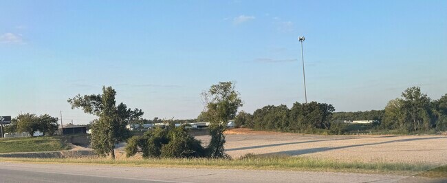
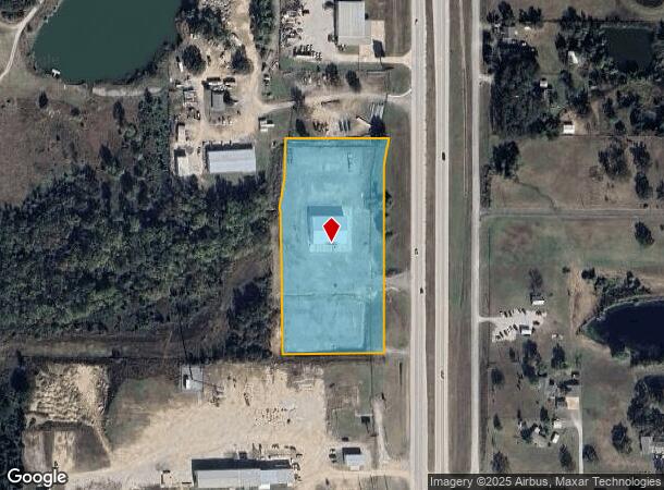
6800 S Highway 97
Tulsa, OK
T18n-R11e
0000-03-018-011-0-006-04
3-18-11 TR LYING IN N SE COM E 1 4 COR SEC MARKED BY BRASS CAP (OK HWY DEPT MONUMENT #C19-144)TH S89' 06 54.51 W250 TO PT ON
Residentialacreage
Creek
X
Oklahoma
40143C0328K
4.26 AC
2024
Creek County
2025
Tulsa
021201
DEMOGRAPHICS near 6800 S Highway 97
1 Mile
3 Mile
5 Mile
2024 Total Population
1,075
13,517
37,893
2029 Population
1,119
13,958
39,566
Pop Growth 2024-2029
+ 4.09%
+ 3.26%
+ 4.42%
Average Age
45
42
41
2024 Total Households
419
5,227
14,630
HH Growth 2024-2029
+ 4.06%
+ 3.25%
+ 4.48%
Median Household Inc
$69,464
$66,595
$62,534
Avg Household Size
2.60
2.50
2.50
2024 Avg HH Vehicles
2.00
2.00
2.00
Median Home Value
$172,670
$167,927
$171,310
Median Year Built
1984
1984
1981
Nearby Places
Map Layers
Map Styles
 Street
 Aerial
- Restaurants
- Banks
- Shops
- Fitness
- Groceries
PUBLIC TRANSPORTATION
AIRPORT
Tulsa International
DRIVE
WALK
Distance
Tulsa International
31 min
21.2 mi
Freight Ports
DRIVE
WALK
Distance
41 min
30.5 mi
SALE & LEASE HISTORY
LISTING DATE
SALE/LEASE

Sep 12, 2024
For Lease
Nearby Properties
Address
Land Use
TOTAL SIZE
Lot Size
Zoning
Address
Land Use
TOTAL SIZE
Lot Size
Zoning
45,095 SF
46.36 AC
AG
Address
Land Use
TOTAL SIZE
Lot Size
Zoning
45,125 SF
7.05 AC
RM1
Address
Land Use
TOTAL SIZE
Lot Size
Zoning
41,456 SF
2.39 AC
RS2
Address
Land Use
TOTAL SIZE
Lot Size
Zoning
33,195 SF
2.60 AC
RS2
Address
Land Use
TOTAL SIZE
Lot Size
Zoning
22,350 SF
14.91 AC
AG
Address
Land Use
TOTAL SIZE
Lot Size
Zoning
16,456 SF
5.67 AC
RE
Address
Land Use
TOTAL SIZE
Lot Size
Zoning
21,694 SF
3.99 AC
AG
Address
Land Use
TOTAL SIZE
Lot Size
Zoning
8,784 SF
7.93 AC
CG
Address
Land Use
TOTAL SIZE
Lot Size
Zoning
4,200 SF
1.73 AC
RE
Address
Land Use
TOTAL SIZE
Lot Size
Zoning
9,060 SF
2.05 AC
CS
Address
Land Use
TOTAL SIZE
Lot Size
Zoning
4,785 SF
7.34 AC
Address
Land Use
TOTAL SIZE
Lot Size
Zoning
13,964 SF
3 AC
RS1
Address
Land Use
TOTAL SIZE
Lot Size
Zoning
9,282 SF
4.83 AC
Address
Land Use
TOTAL SIZE
Lot Size
Zoning
8,400 SF
8.86 AC
RE
Address
Land Use
TOTAL SIZE
Lot Size
Zoning
20,625 SF
13.39 AC
TM
Address
Land Use
TOTAL SIZE
Lot Size
Zoning
13,953 SF
3.74 AC
RE
Address
Land Use
TOTAL SIZE
Lot Size
Zoning
11,682 SF
2.07 AC
AG
Address
Land Use
TOTAL SIZE
Lot Size
Zoning
7,266 SF
5 AC
RS3
Address
Land Use
TOTAL SIZE
Lot Size
Zoning
89,421 SF
6.14 AC
CS
Address
Land Use
TOTAL SIZE
Lot Size
Zoning
9,600 SF
3.02 AC
Address
Land Use
TOTAL SIZE
Lot Size
Zoning
9,360 SF
3.85 AC
C2
Address
Land Use
TOTAL SIZE
Lot Size
Zoning
13,017 SF
2.35 AC
RE
Address
Land Use
TOTAL SIZE
Lot Size
Zoning
51,981 SF
4.87 AC
CS
Address
Land Use
TOTAL SIZE
Lot Size
Zoning
50,880 SF
4.08 AC
RS2
Address
Land Use
TOTAL SIZE
Lot Size
Zoning
4,324 SF
1.99 AC
CS
Address
Land Use
TOTAL SIZE
Lot Size
Zoning
10,822 SF
10.32 AC
Address
Land Use
TOTAL SIZE
Lot Size
Zoning
25,675 SF
18.15 AC
Address
Land Use
TOTAL SIZE
Lot Size
Zoning
7,076 SF
1.30 AC
Address
Land Use
TOTAL SIZE
Lot Size
Zoning
6,104 SF
2.49 AC
RS2
Address
Land Use
TOTAL SIZE
Lot Size
Zoning
21,000 SF
3.85 AC
The World's #1 Commercial Real Estate Marketplace
Connect with us
© 2025 CoStar Group
The information above has been obtained from sources believed reliable. While we do not doubt its accuracy we have not verified it and make no guarantee, warranty or representation about it. It is your responsibility to independently confirm its accuracy and completeness. Any projections, opinions, assumptions, or estimates used are for example only and do not represent the current or future performance of the property. The value of this transaction to you depends on tax and other factors which should be evaluated by your tax, financial, and legal advisors. You and your advisors should conduct a careful, independent investigation of the property to determine to your satisfaction the suitability of the property for your needs.