Property Record
6801 Avenue 430, Reedley, CA 93654
NEARBY LISTINGS FOR SALE OR LEASE
Property Detail
6801 Avenue 430
Visalia-Porterville, CA
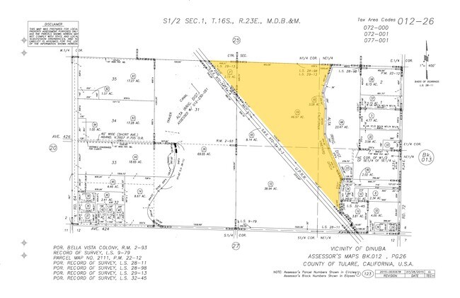
Bella Vista Colony
012-260-069-000
LOT 30 BELLA VISTA COLONYRM 2-93
Lightindustrial
Tulare
A
California
06107C0310E
30
2024
46.97 AC
2025
NW Outlying Tulare County
000303
Visalia/Porterville
58,366 SF
DEMOGRAPHICS near 6801 Avenue 430
1 Mile
3 Mile
5 Mile
2024 Total Population
428
42,158
57,372
2029 Population
456
43,205
58,683
Pop Growth 2024-2029
+ 6.54%
+ 2.48%
+ 2.29%
Average Age
36
35
35
2024 Total Households
121
11,727
15,875
HH Growth 2024-2029
+ 6.61%
+ 2.48%
+ 2.26%
Median Household Inc
$77,500
$57,610
$56,339
Avg Household Size
3.40
3.50
3.50
2024 Avg HH Vehicles
3.00
2.00
2.00
Median Home Value
$370,967
$261,819
$270,718
Median Year Built
1992
1978
1978
Nearby Places
Map Layers
Map Styles
 Street
 Aerial
- Restaurants
- Banks
- Shops
- Fitness
- Groceries
PUBLIC TRANSPORTATION
AIRPORT
Fresno Yosemite International
DRIVE
WALK
Distance
Fresno Yosemite International
48 min
29.6 mi
Freight Ports
Port of Stockton
DRIVE
WALK
Distance
Port of Stockton
190 min
153.9 mi
Nearby Properties
Address
Land Use
TOTAL SIZE
Lot Size
Zoning
Address
Land Use
TOTAL SIZE
Lot Size
Zoning
1,022,425 SF
97.93 AC
M-1
Address
Land Use
TOTAL SIZE
Lot Size
Zoning
311,815 SF
18.19 AC
M-1
Address
Land Use
TOTAL SIZE
Lot Size
Zoning
379,550 SF
28.55 AC
MP
Address
Land Use
TOTAL SIZE
Lot Size
Zoning
23.40 AC
Address
Land Use
TOTAL SIZE
Lot Size
Zoning
89,902 SF
32.05 AC
AE20
Address
Land Use
TOTAL SIZE
Lot Size
Zoning
178,455 SF
9 AC
RM2
Address
Land Use
TOTAL SIZE
Lot Size
Zoning
196,548 SF
9.81 AC
R2P
Address
Land Use
TOTAL SIZE
Lot Size
Zoning
52,140 SF
10 AC
M-1
Address
Land Use
TOTAL SIZE
Lot Size
Zoning
86,883 SF
9.37 AC
RCO
Address
Land Use
TOTAL SIZE
Lot Size
Zoning
68,550 SF
12.58 AC
MP
Address
Land Use
TOTAL SIZE
Lot Size
Zoning
122,985 SF
6.32 AC
AL20
Address
Land Use
TOTAL SIZE
Lot Size
Zoning
102,803 SF
5.61 AC
RM3
Address
Land Use
TOTAL SIZE
Lot Size
Zoning
68,453 SF
4.35 AC
RMSP
Address
Land Use
TOTAL SIZE
Lot Size
Zoning
68,775 SF
4.68 AC
RM-2
Address
Land Use
TOTAL SIZE
Lot Size
Zoning
135.31 AC
Address
Land Use
TOTAL SIZE
Lot Size
Zoning
57,608 SF
44.37 AC
AE-20
Address
Land Use
TOTAL SIZE
Lot Size
Zoning
62,142 SF
4.18 AC
RM2
Address
Land Use
TOTAL SIZE
Lot Size
Zoning
22,834 SF
6.66 AC
MP
Address
Land Use
TOTAL SIZE
Lot Size
Zoning
40,041 SF
4.56 AC
AL20
Address
Land Use
TOTAL SIZE
Lot Size
Zoning
81,771 SF
5.37 AC
RM-2
Address
Land Use
TOTAL SIZE
Lot Size
Zoning
19,944 SF
18.76 AC
AE20
Address
Land Use
TOTAL SIZE
Lot Size
Zoning
38,285 SF
4.53 AC
C-3
Address
Land Use
TOTAL SIZE
Lot Size
Zoning
38,907 SF
1.24 AC
C-4
Address
Land Use
TOTAL SIZE
Lot Size
Zoning
59,906 SF
0.78 AC
RM2
Address
Land Use
TOTAL SIZE
Lot Size
Zoning
92,923 SF
12.33 AC
M-1
Address
Land Use
TOTAL SIZE
Lot Size
Zoning
2,998 SF
1.09 AC
C-4
Address
Land Use
TOTAL SIZE
Lot Size
Zoning
24,521 SF
2.81 AC
R1
Address
Land Use
TOTAL SIZE
Lot Size
Zoning
22,177 SF
1.99 AC
AL20
Address
Land Use
TOTAL SIZE
Lot Size
Zoning
83,071 SF
12.05 AC
MP
The World's #1 Commercial Real Estate Marketplace
Connect with us
© 2025 CoStar Group
The information above has been obtained from sources believed reliable. While we do not doubt its accuracy we have not verified it and make no guarantee, warranty or representation about it. It is your responsibility to independently confirm its accuracy and completeness. Any projections, opinions, assumptions, or estimates used are for example only and do not represent the current or future performance of the property. The value of this transaction to you depends on tax and other factors which should be evaluated by your tax, financial, and legal advisors. You and your advisors should conduct a careful, independent investigation of the property to determine to your satisfaction the suitability of the property for your needs.