Property Record
6801 Coit Rd, Plano, TX 75024
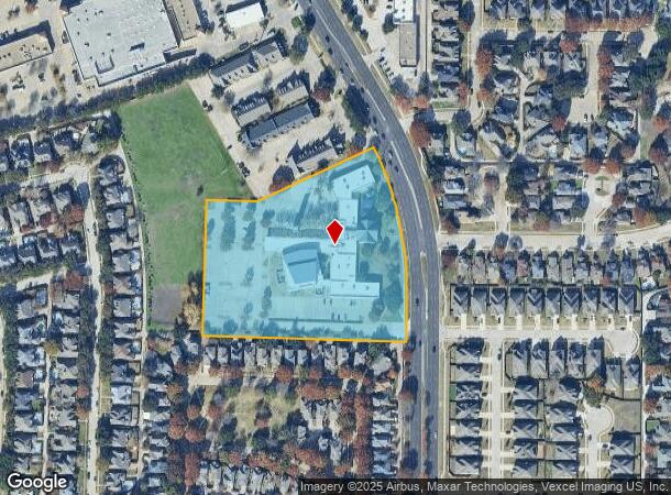
Property Detail
6801 Coit Rd
Dallas-Fort Worth-Arlington, TX
Preston Meadow Lutheran Church (Cpl)
R-2499-001-001R-1
PRESTON MEADOW LUTHERAN CHURCH, BLK 1, LOT 1R
Religious
Collin
X
Texas
48085C0360K
1r
0
6.35 AC
2025
Plano
031674
Dallas/Ft Worth
54,896 SF
NEARBY LISTINGS FOR SALE OR LEASE
DEMOGRAPHICS near 6801 Coit Rd
1 mile
3 mile
5 mile
2024 Total Population
15,738
148,502
348,406
2029 Population
18,991
179,846
423,462
Pop Growth 2024-2029
+ 20.67%
+ 21.11%
+ 21.54%
Average Age
42
40
40
2024 Total Households
5,742
55,725
139,456
HH Growth 2024-2029
+ 20.92%
+ 21.39%
+ 21.97%
Median Household Inc
$121,677
$117,933
$104,868
Avg Household Size
2.70
2.60
2.50
2024 Avg HH Vehicles
2.00
2.00
2.00
Median Home Value
$426,231
$414,456
$422,833
Median Year Built
1991
1993
1995
Nearby Places
Map Layers
Map Styles
 Street
 Aerial
Transit
 Traffic
 Biking
Places
Listings with unknown addresses are not visible on the map
- Restaurants
- Banks
- Shops
- Fitness
- Groceries
PUBLIC TRANSPORTATION
AIRPORT
Dallas Love Field
Drive
Walk
Distance
Dallas Love Field
33 min
22.4 mi
Dallas-Fort Worth International
Drive
Walk
Distance
Dallas-Fort Worth International
33 min
25.2 mi
Freight Ports
Port of Shreveport
Drive
Walk
Distance
Port of Shreveport
234 min
209.1 mi
Nearby Properties
Address
Land Use
TOTAL SIZE
Lot Size
Zoning
Address
Land Use
TOTAL SIZE
Lot Size
Zoning
779,629 SF
56 AC
Address
Land Use
TOTAL SIZE
Lot Size
Zoning
584,998 SF
23.45 AC
Address
Land Use
TOTAL SIZE
Lot Size
Zoning
320,098 SF
20 AC
CE
Address
Land Use
TOTAL SIZE
Lot Size
Zoning
606,071 SF
64.75 AC
SFR
Address
Land Use
TOTAL SIZE
Lot Size
Zoning
1,578,500 SF
91.04 AC
Address
Land Use
TOTAL SIZE
Lot Size
Zoning
401,260 SF
23.33 AC
CE
Address
Land Use
TOTAL SIZE
Lot Size
Zoning
207,793 SF
12.48 AC
CE
Address
Land Use
TOTAL SIZE
Lot Size
Zoning
252,305 SF
9.22 AC
Address
Land Use
TOTAL SIZE
Lot Size
Zoning
341,917 SF
2.86 AC
CB-1
Address
Land Use
TOTAL SIZE
Lot Size
Zoning
545,224 SF
42.80 AC
Address
Land Use
TOTAL SIZE
Lot Size
Zoning
442,484 SF
APTS
Address
Land Use
TOTAL SIZE
Lot Size
Zoning
435,683 SF
18.25 AC
COMM
Address
Land Use
TOTAL SIZE
Lot Size
Zoning
388,870 SF
25.54 AC
Address
Land Use
TOTAL SIZE
Lot Size
Zoning
442,184 SF
11.65 AC
MF-E
Address
Land Use
TOTAL SIZE
Lot Size
Zoning
393,074 SF
24.03 AC
MFM
Address
Land Use
TOTAL SIZE
Lot Size
Zoning
156,000 SF
9 AC
CE
Address
Land Use
TOTAL SIZE
Lot Size
Zoning
296,434 SF
19.66 AC
CE
Address
Land Use
TOTAL SIZE
Lot Size
Zoning
382,817 SF
47.69 AC
CE
Address
Land Use
TOTAL SIZE
Lot Size
Zoning
495,663 SF
8.68 AC
COMM
Address
Land Use
TOTAL SIZE
Lot Size
Zoning
467,134 SF
24.13 AC
MF-M
Address
Land Use
TOTAL SIZE
Lot Size
Zoning
145,000 SF
16.01 AC
Address
Land Use
TOTAL SIZE
Lot Size
Zoning
405,642 SF
5.55 AC
MF-E
Address
Land Use
TOTAL SIZE
Lot Size
Zoning
308,670 SF
25.10 AC
Address
Land Use
TOTAL SIZE
Lot Size
Zoning
461,983 SF
43.65 AC
Address
Land Use
TOTAL SIZE
Lot Size
Zoning
486,949 SF
6.42 AC
O-M
Address
Land Use
TOTAL SIZE
Lot Size
Zoning
230,621 SF
18.91 AC
CE
Address
Land Use
TOTAL SIZE
Lot Size
Zoning
373,261 SF
5.55 AC
Address
Land Use
TOTAL SIZE
Lot Size
Zoning
328,176 SF
6.79 AC
CE
Address
Land Use
TOTAL SIZE
Lot Size
Zoning
394,405 SF
39.02 AC
Address
Land Use
TOTAL SIZE
Lot Size
Zoning
346,959 SF
12.68 AC
RT
The World's #1 Commercial Real Estate Marketplace
Connect with us
© 2026 CoStar Group
The information above has been obtained from sources believed reliable. While we do not doubt its accuracy we have not verified it and make no guarantee, warranty or representation about it. It is your responsibility to independently confirm its accuracy and completeness. Any projections, opinions, assumptions, or estimates used are for example only and do not represent the current or future performance of the property. The value of this transaction to you depends on tax and other factors which should be evaluated by your tax, financial, and legal advisors. You and your advisors should conduct a careful, independent investigation of the property to determine to your satisfaction the suitability of the property for your needs.