Property Record
6801 Mccart Ave, Fort Worth, TX 76133
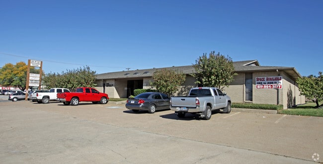


Property Detail
6801 Mccart Ave
Dallas-Fort Worth-Arlington, TX
SOUTH RIDGE ADDITION BLOCK 25 LOT 1
02882663
TARRANT
Commercialnec
Texas
AE The base floodplain where base flood elevations are provided. AE Zones are now used on new format FIRMs instead of A1-A30 Zones.
1
2025
0.52 AC
2025
West Southwest Ft Worth
105705
Dallas/Ft Worth
9,670 SF
NEARBY LISTINGS FOR SALE OR LEASE
DEMOGRAPHICS near 6801 Mccart Ave
1 mile
3 mile
5 mile
2025 Total Population
21,292
137,341
270,491
2030 Population
22,148
144,328
286,163
Pop Growth 2025-2030
+ 4.02%
+ 5.09%
+ 5.79%
Average Age
37
37
37
2025 Total Households
7,773
47,693
95,625
HH Growth 2025-2030
+ 4.17%
+ 5.17%
+ 6.01%
Median Household Inc
$66,339
$74,209
$75,186
Avg Household Size
2.70
2.80
2.70
2025 Avg HH Vehicles
2.00
2.00
2.00
Median Home Value
$243,004
$270,616
$290,474
Median Year Built
1983
1984
1986
Nearby Places
Map Layers
Map Styles
 Street
 Aerial
Layers
 Traffic
 Biking
Places
Listings with unknown addresses are not visible on the map
- Restaurants
- Banks
- Shops
- Fitness
- Groceries
PUBLIC TRANSPORTATION
AIRPORT
Dallas-Fort Worth International
Drive
Walk
Distance
Dallas-Fort Worth International
46 min
34.4 mi
Dallas Love Field
Drive
Walk
Distance
Dallas Love Field
57 min
43.0 mi
SALE & LEASE HISTORY
LISTING DATE
SALE/LEASE

Feb 21, 2019
For Lease
Nearby Properties
Address
Land Use
TOTAL SIZE
Lot Size
Zoning
Address
Land Use
TOTAL SIZE
Lot Size
Zoning
323,685 SF
19.61 AC
Address
Land Use
TOTAL SIZE
Lot Size
Zoning
781,200 SF
37.80 AC
Address
Land Use
TOTAL SIZE
Lot Size
Zoning
288,700 SF
27.02 AC
Address
Land Use
TOTAL SIZE
Lot Size
Zoning
660,000 SF
33.91 AC
Address
Land Use
TOTAL SIZE
Lot Size
Zoning
319,017 SF
14.68 AC
Address
Land Use
TOTAL SIZE
Lot Size
Zoning
193,098 SF
25 AC
Address
Land Use
TOTAL SIZE
Lot Size
Zoning
462,777 SF
37.49 AC
Address
Land Use
TOTAL SIZE
Lot Size
Zoning
426,348 SF
128.78 AC
Address
Land Use
TOTAL SIZE
Lot Size
Zoning
489,679 SF
27.08 AC
Address
Land Use
TOTAL SIZE
Lot Size
Zoning
281,410 SF
15.70 AC
Address
Land Use
TOTAL SIZE
Lot Size
Zoning
147,466 SF
19.19 AC
Address
Land Use
TOTAL SIZE
Lot Size
Zoning
272,395 SF
6.99 AC
Address
Land Use
TOTAL SIZE
Lot Size
Zoning
320,700 SF
12.41 AC
Address
Land Use
TOTAL SIZE
Lot Size
Zoning
456,500 SF
29.55 AC
Address
Land Use
TOTAL SIZE
Lot Size
Zoning
234,747 SF
9.11 AC
Address
Land Use
TOTAL SIZE
Lot Size
Zoning
123,502 SF
12.66 AC
Address
Land Use
TOTAL SIZE
Lot Size
Zoning
202,247 SF
9.56 AC
Address
Land Use
TOTAL SIZE
Lot Size
Zoning
230,452 SF
63.63 AC
Address
Land Use
TOTAL SIZE
Lot Size
Zoning
214,416 SF
8.80 AC
Address
Land Use
TOTAL SIZE
Lot Size
Zoning
236,872 SF
10.35 AC
Address
Land Use
TOTAL SIZE
Lot Size
Zoning
182,258 SF
9.33 AC
Address
Land Use
TOTAL SIZE
Lot Size
Zoning
529,524 SF
25.37 AC
Address
Land Use
TOTAL SIZE
Lot Size
Zoning
223,927 SF
9.57 AC
Address
Land Use
TOTAL SIZE
Lot Size
Zoning
86,995 SF
6.01 AC
Address
Land Use
TOTAL SIZE
Lot Size
Zoning
186,352 SF
11.01 AC
Address
Land Use
TOTAL SIZE
Lot Size
Zoning
198,266 SF
10 AC
Address
Land Use
TOTAL SIZE
Lot Size
Zoning
238,532 SF
11.18 AC
Address
Land Use
TOTAL SIZE
Lot Size
Zoning
204,292 SF
10.38 AC
Address
Land Use
TOTAL SIZE
Lot Size
Zoning
113,900 SF
10.26 AC
Address
Land Use
TOTAL SIZE
Lot Size
Zoning
287,040 SF
17.51 AC
The World's #1 Commercial Real Estate Marketplace
Connect with us
© 2026 CoStar Group
The information above has been obtained from sources believed reliable. While we do not doubt its accuracy we have not verified it and make no guarantee, warranty or representation about it. It is your responsibility to independently confirm its accuracy and completeness. Any projections, opinions, assumptions, or estimates used are for example only and do not represent the current or future performance of the property. The value of this transaction to you depends on tax and other factors which should be evaluated by your tax, financial, and legal advisors. You and your advisors should conduct a careful, independent investigation of the property to determine to your satisfaction the suitability of the property for your needs.