Property Record
6801 Mcdivitt Dr, Bakersfield, CA 93313
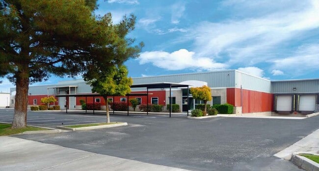
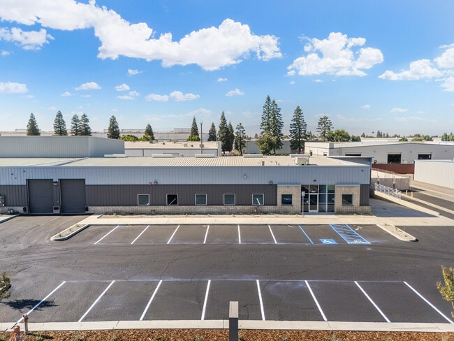

Property Detail
6801 Mcdivitt Dr
Bakersfield-Delano, CA
PARCEL MAP 6963 , LOT P 17
385-412-25-00-2
KERN
Industrialacreage
California
M-2
p
B and X Area of moderate flood hazard, usually the area between the limits of the 100-year and 500-year floods.
0.45 AC
2024
Southwest Bakersfield
2025
Bakersfield
003131
NEARBY LISTINGS FOR SALE OR LEASE
DEMOGRAPHICS near 6801 Mcdivitt Dr
1 mile
3 mile
5 mile
2025 Total Population
14,970
141,245
279,287
2030 Population
15,008
143,000
283,549
Pop Growth 2025-2030
+ 0.25%
+ 1.24%
+ 1.53%
Average Age
35
36
35
2025 Total Households
4,947
45,856
87,532
HH Growth 2025-2030
+ 0.20%
+ 1.12%
+ 1.49%
Median Household Inc
$73,648
$81,081
$78,254
Avg Household Size
3.00
3.00
3.10
2025 Avg HH Vehicles
2.00
2.00
2.00
Median Home Value
$335,893
$364,336
$362,007
Median Year Built
1987
1985
1985
Nearby Places
Map Layers
Map Styles
 Street
 Aerial
Transit
 Traffic
 Biking
Places
Listings with unknown addresses are not visible on the map
- Restaurants
- Banks
- Shops
- Fitness
- Groceries
PUBLIC TRANSPORTATION
COMMUTER RAIL
Bakersfield (San Joaquins - Amtrak)
Drive
Walk
Distance
Bakersfield (San Joaquins - Amtrak)
17 min
9.3 mi
AIRPORT
Meadows Field
Drive
Walk
Distance
Meadows Field
25 min
12.8 mi
Freight Ports
The Port of Hueneme
Drive
Walk
Distance
The Port of Hueneme
153 min
121.0 mi
SALE & LEASE HISTORY
LISTING DATE
SALE/LEASE

Sep 25, 2016
For Lease
Sep 24, 2016
For Sale
Sep 09, 2025
For Lease
May 01, 2018
For Lease
May 01, 2018
For Sale
Mar 31, 2023
For Lease
Mar 09, 2021
For Sale
Feb 21, 2025
For Lease
Feb 13, 2024
For Lease
Aug 18, 2022
For Lease
Nearby Properties
Address
Land Use
TOTAL SIZE
Lot Size
Zoning
Address
Land Use
TOTAL SIZE
Lot Size
Zoning
587,976 SF
40.01 AC
M-2
Address
Land Use
TOTAL SIZE
Lot Size
Zoning
114,500 SF
12.02 AC
C-2
Address
Land Use
TOTAL SIZE
Lot Size
Zoning
5,850 SF
10.96 AC
C2
Address
Land Use
TOTAL SIZE
Lot Size
Zoning
354,000 SF
20 AC
M2
Address
Land Use
TOTAL SIZE
Lot Size
Zoning
14,529 SF
27.73 AC
R-2
Address
Land Use
TOTAL SIZE
Lot Size
Zoning
241,051 SF
18.48 AC
CO
Address
Land Use
TOTAL SIZE
Lot Size
Zoning
14,500 SF
33.82 AC
C2
Address
Land Use
TOTAL SIZE
Lot Size
Zoning
253,532 SF
14.69 AC
Address
Land Use
TOTAL SIZE
Lot Size
Zoning
185,181 SF
14.67 AC
C2
Address
Land Use
TOTAL SIZE
Lot Size
Zoning
269,429 SF
12.71 AC
R-2
Address
Land Use
TOTAL SIZE
Lot Size
Zoning
138,559 SF
11.92 AC
C-2 PCD
Address
Land Use
TOTAL SIZE
Lot Size
Zoning
15,027 SF
17.72 AC
C-2
Address
Land Use
TOTAL SIZE
Lot Size
Zoning
218,345 SF
19.54 AC
PCD
Address
Land Use
TOTAL SIZE
Lot Size
Zoning
37,760 SF
12.16 AC
R3
Address
Land Use
TOTAL SIZE
Lot Size
Zoning
99,368 SF
6.95 AC
CO
Address
Land Use
TOTAL SIZE
Lot Size
Zoning
233,512 SF
9.19 AC
R-3
Address
Land Use
TOTAL SIZE
Lot Size
Zoning
214,746 SF
14.91 AC
Address
Land Use
TOTAL SIZE
Lot Size
Zoning
210,432 SF
13.52 AC
R-2
Address
Land Use
TOTAL SIZE
Lot Size
Zoning
93,274 SF
6.20 AC
R-2
Address
Land Use
TOTAL SIZE
Lot Size
Zoning
223,557 SF
21.31 AC
PCD
Address
Land Use
TOTAL SIZE
Lot Size
Zoning
83,388 SF
3.15 AC
Address
Land Use
TOTAL SIZE
Lot Size
Zoning
192,500 SF
11.48 AC
R-2
Address
Land Use
TOTAL SIZE
Lot Size
Zoning
62,941 SF
8.79 AC
M-1
Address
Land Use
TOTAL SIZE
Lot Size
Zoning
79,325 SF
7.77 AC
C-2
Address
Land Use
TOTAL SIZE
Lot Size
Zoning
83,936 SF
4.39 AC
R-2
Address
Land Use
TOTAL SIZE
Lot Size
Zoning
88,988 SF
9.82 AC
C-2
Address
Land Use
TOTAL SIZE
Lot Size
Zoning
24,888 SF
5.75 AC
WM-R2
Address
Land Use
TOTAL SIZE
Lot Size
Zoning
63,702 SF
6.82 AC
WM C-O
Address
Land Use
TOTAL SIZE
Lot Size
Zoning
Address
Land Use
TOTAL SIZE
Lot Size
Zoning
115,267 SF
9.14 AC
C-2
The World's #1 Commercial Real Estate Marketplace
Connect with us
© 2026 CoStar Group
The information above has been obtained from sources believed reliable. While we do not doubt its accuracy we have not verified it and make no guarantee, warranty or representation about it. It is your responsibility to independently confirm its accuracy and completeness. Any projections, opinions, assumptions, or estimates used are for example only and do not represent the current or future performance of the property. The value of this transaction to you depends on tax and other factors which should be evaluated by your tax, financial, and legal advisors. You and your advisors should conduct a careful, independent investigation of the property to determine to your satisfaction the suitability of the property for your needs.