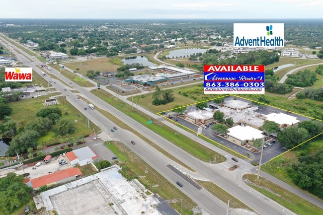
Property Record
6801 Us Highway 27 N, Sebring, FL 33870


Current Lease Availabilities
NEARBY LISTINGS FOR SALE OR LEASE
Property Detail
6801 Us Highway 27 N
C-04-34-28-030-0410-0010
Sun N Lake Est
Officebuilding
SUN N LAKE EST OF SEBRING UNIT 3 PB 9-PG 49 NLY 400 FT OF SLY 651 FT OF ELY 450 FT + A 22 X 193 FT STRIP ALL IN BLK 41
X
Highlands
12055C0117C
Florida
0
4.23 AC
2025
Florida Central South Area
960503
Other Market Areas
42,856 SF
Sebring, FL
DEMOGRAPHICS near 6801 Us Highway 27 N
1 Mile
3 Mile
5 Mile
2024 Total Population
3,322
20,158
42,309
2029 Population
3,630
21,956
46,093
Pop Growth 2024-2029
+ 9.27%
+ 8.92%
+ 8.94%
Average Age
49
51
50
2024 Total Households
1,451
8,991
18,782
HH Growth 2024-2029
+ 9.17%
+ 9.02%
+ 9.13%
Median Household Inc
$64,631
$57,323
$50,415
Avg Household Size
2.20
2.20
2.20
2024 Avg HH Vehicles
2.00
2.00
2.00
Median Home Value
$142,357
$130,062
$142,876
Median Year Built
1987
1987
1985
Nearby Places
Map Layers
Map Styles
 Street
 Aerial
- Restaurants
- Banks
- Shops
- Fitness
- Groceries
PUBLIC TRANSPORTATION
COMMUTER RAIL
DRIVE
WALK
Distance
13 min
6.7 mi
Nearby Properties
Address
Land Use
TOTAL SIZE
Lot Size
Zoning
Address
Land Use
TOTAL SIZE
Lot Size
Zoning
319,284 SF
76.37 AC
P
Address
Land Use
TOTAL SIZE
Lot Size
Zoning
398,166 SF
82.52 AC
PU
Address
Land Use
TOTAL SIZE
Lot Size
Zoning
155,486 SF
21.71 AC
C1
Address
Land Use
TOTAL SIZE
Lot Size
Zoning
280 SF
17.56 AC
CG3
Address
Land Use
TOTAL SIZE
Lot Size
Zoning
118,053 SF
21.01 AC
P
Address
Land Use
TOTAL SIZE
Lot Size
Zoning
116,629 SF
19.72 AC
EU
Address
Land Use
TOTAL SIZE
Lot Size
Zoning
91,625 SF
5 AC
R3
Address
Land Use
TOTAL SIZE
Lot Size
Zoning
176,175 SF
22.73 AC
C1
Address
Land Use
TOTAL SIZE
Lot Size
Zoning
104,876 SF
33.52 AC
B3
Address
Land Use
TOTAL SIZE
Lot Size
Zoning
62,304 SF
6.18 AC
B3
Address
Land Use
TOTAL SIZE
Lot Size
Zoning
71,695 SF
44.72 AC
PU
Address
Land Use
TOTAL SIZE
Lot Size
Zoning
23,187 SF
0.68 AC
P
Address
Land Use
TOTAL SIZE
Lot Size
Zoning
119,540 SF
15.17 AC
B3
Address
Land Use
TOTAL SIZE
Lot Size
Zoning
71,609 SF
15.32 AC
P
Address
Land Use
TOTAL SIZE
Lot Size
Zoning
46,625 SF
6.45 AC
R3FUD
Address
Land Use
TOTAL SIZE
Lot Size
Zoning
39,144 SF
1.67 AC
C1
Address
Land Use
TOTAL SIZE
Lot Size
Zoning
102,610 SF
5.06 AC
C1
Address
Land Use
TOTAL SIZE
Lot Size
Zoning
55,344 SF
8.15 AC
C1
Address
Land Use
TOTAL SIZE
Lot Size
Zoning
26,587 SF
1.80 AC
B3
Address
Land Use
TOTAL SIZE
Lot Size
Zoning
68,140 SF
6.66 AC
B3
Address
Land Use
TOTAL SIZE
Lot Size
Zoning
280 SF
5.46 AC
CG3
Address
Land Use
TOTAL SIZE
Lot Size
Zoning
34,782 SF
8.25 AC
B4
Address
Land Use
TOTAL SIZE
Lot Size
Zoning
17,006 SF
2.59 AC
B2
Address
Land Use
TOTAL SIZE
Lot Size
Zoning
22,340 SF
2.22 AC
C1
Address
Land Use
TOTAL SIZE
Lot Size
Zoning
29,041 SF
1.39 AC
B2CU
Address
Land Use
TOTAL SIZE
Lot Size
Zoning
15,369 SF
9.04 AC
R1
Address
Land Use
TOTAL SIZE
Lot Size
Zoning
39,772 SF
5.45 AC
C2
Address
Land Use
TOTAL SIZE
Lot Size
Zoning
17,762 SF
1.52 AC
R1A
Address
Land Use
TOTAL SIZE
Lot Size
Zoning
78,253 SF
9.24 AC
R3
Address
Land Use
TOTAL SIZE
Lot Size
Zoning
19,500 SF
19.07 AC
I1
The World's #1 Commercial Real Estate Marketplace
Connect with us
© 2026 CoStar Group
The information above has been obtained from sources believed reliable. While we do not doubt its accuracy we have not verified it and make no guarantee, warranty or representation about it. It is your responsibility to independently confirm its accuracy and completeness. Any projections, opinions, assumptions, or estimates used are for example only and do not represent the current or future performance of the property. The value of this transaction to you depends on tax and other factors which should be evaluated by your tax, financial, and legal advisors. You and your advisors should conduct a careful, independent investigation of the property to determine to your satisfaction the suitability of the property for your needs.