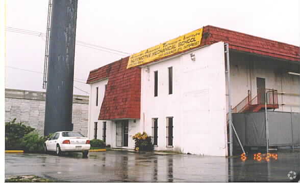
Property Record
6801 W 20Th Ave, Hialeah, FL 33014


NEARBY LISTINGS FOR SALE OR LEASE
Property Detail
6801 W 20Th Ave
Miami-Miami Beach-Kendall, FL
Sutton-Walker-Watkins Sub
04-2026-048-0010
SUTTON-WALKER-WATKINS SUB PB 120-31 LOT 1 BLK 1 LOT SIZE 21350 SQ FT OR 18130-1112 0598 1
Foodprocessing
Miami/Dade
AH
Florida
12086C0114L
1
0
0.49 AC
2025
Hialeah
009316
South Florida
7,275 SF
DEMOGRAPHICS near 6801 W 20Th Ave
1 Mile
3 Mile
5 Mile
2024 Total Population
38,556
190,993
406,615
2029 Population
37,301
185,304
395,619
Pop Growth 2024-2029
(3.26%)
(2.98%)
(2.70%)
Average Age
44
43
42
2024 Total Households
13,130
63,432
132,494
HH Growth 2024-2029
(3.71%)
(3.43%)
(3.10%)
Median Household Inc
$39,780
$51,902
$55,022
Avg Household Size
2.90
2.90
3.00
2024 Avg HH Vehicles
2.00
2.00
2.00
Median Home Value
$265,030
$331,770
$349,072
Median Year Built
1979
1980
1982
Nearby Places
Map Layers
Map Styles
 Street
 Aerial
- Restaurants
- Banks
- Shops
- Fitness
- Groceries
PUBLIC TRANSPORTATION
COMMUTER RAIL
Palmetto (Metrorail Green Line - Miami-Dade Transit (Metrorail/Metromover))
DRIVE
WALK
Distance
Palmetto (Metrorail Green Line - Miami-Dade Transit (Metrorail/Metromover))
8 min
3.5 mi
Okeechobee (Metrorail Green Line - Miami-Dade Transit (Metrorail/Metromover))
DRIVE
WALK
Distance
Okeechobee (Metrorail Green Line - Miami-Dade Transit (Metrorail/Metromover))
9 min
4.2 mi
AIRPORT
Miami International
DRIVE
WALK
Distance
Miami International
17 min
8.6 mi
Fort Lauderdale/Hollywood International
DRIVE
WALK
Distance
Fort Lauderdale/Hollywood International
34 min
22.8 mi
Freight Ports
Port of Miami
DRIVE
WALK
Distance
Port of Miami
29 min
15.3 mi
Nearby Properties
Address
Land Use
TOTAL SIZE
Lot Size
Zoning
Address
Land Use
TOTAL SIZE
Lot Size
Zoning
614,708 SF
22.54 AC
4400
Address
Land Use
TOTAL SIZE
Lot Size
Zoning
636,721 SF
52.61 AC
2800
Address
Land Use
TOTAL SIZE
Lot Size
Zoning
439,520 SF
20.20 AC
9400
Address
Land Use
TOTAL SIZE
Lot Size
Zoning
725,624 SF
34.80 AC
7300
Address
Land Use
TOTAL SIZE
Lot Size
Zoning
526,059 SF
18.99 AC
6407
Address
Land Use
TOTAL SIZE
Lot Size
Zoning
696,550 SF
2.97 AC
6109
Address
Land Use
TOTAL SIZE
Lot Size
Zoning
301,593 SF
16 AC
7100
Address
Land Use
TOTAL SIZE
Lot Size
Zoning
1,165,101 SF
115.84 AC
8000
Address
Land Use
TOTAL SIZE
Lot Size
Zoning
538,715 SF
24.72 AC
7100
Address
Land Use
TOTAL SIZE
Lot Size
Zoning
399,805 SF
14.02 AC
8000
Address
Land Use
TOTAL SIZE
Lot Size
Zoning
322,084 SF
6.60 AC
7100
Address
Land Use
TOTAL SIZE
Lot Size
Zoning
344,465 SF
5.03 AC
6400
Address
Land Use
TOTAL SIZE
Lot Size
Zoning
648,867 SF
33.08 AC
7100
Address
Land Use
TOTAL SIZE
Lot Size
Zoning
355,120 SF
18 AC
5000
Address
Land Use
TOTAL SIZE
Lot Size
Zoning
359,483 SF
11.34 AC
8000
Address
Land Use
TOTAL SIZE
Lot Size
Zoning
223,543 SF
39.40 AC
6407
Address
Land Use
TOTAL SIZE
Lot Size
Zoning
382,421 SF
19.66 AC
3700
Address
Land Use
TOTAL SIZE
Lot Size
Zoning
400,062 SF
33.33 AC
0101
Address
Land Use
TOTAL SIZE
Lot Size
Zoning
315,033 SF
11.48 AC
6109
Address
Land Use
TOTAL SIZE
Lot Size
Zoning
419,656 SF
8.61 AC
6400
Address
Land Use
TOTAL SIZE
Lot Size
Zoning
445,429 SF
4.45 AC
6400
Address
Land Use
TOTAL SIZE
Lot Size
Zoning
177,893 SF
15.02 AC
7100
Address
Land Use
TOTAL SIZE
Lot Size
Zoning
313,129 SF
16.06 AC
7100
Address
Land Use
TOTAL SIZE
Lot Size
Zoning
293,962 SF
9.99 AC
4400
Address
Land Use
TOTAL SIZE
Lot Size
Zoning
249,486 SF
11.84 AC
7100
Address
Land Use
TOTAL SIZE
Lot Size
Zoning
196,118 SF
11.06 AC
7100
Address
Land Use
TOTAL SIZE
Lot Size
Zoning
308,699 SF
28.97 AC
7100
Address
Land Use
TOTAL SIZE
Lot Size
Zoning
478,031 SF
1.72 AC
6600
Address
Land Use
TOTAL SIZE
Lot Size
Zoning
221,731 SF
11.17 AC
7100
Address
Land Use
TOTAL SIZE
Lot Size
Zoning
260,794 SF
12.50 AC
7100
The World's #1 Commercial Real Estate Marketplace
Connect with us
© 2026 CoStar Group
The information above has been obtained from sources believed reliable. While we do not doubt its accuracy we have not verified it and make no guarantee, warranty or representation about it. It is your responsibility to independently confirm its accuracy and completeness. Any projections, opinions, assumptions, or estimates used are for example only and do not represent the current or future performance of the property. The value of this transaction to you depends on tax and other factors which should be evaluated by your tax, financial, and legal advisors. You and your advisors should conduct a careful, independent investigation of the property to determine to your satisfaction the suitability of the property for your needs.