Property Record
6802 S Highway 35, Alvin, TX 77511
NEARBY LISTINGS FOR SALE OR LEASE
Property Detail
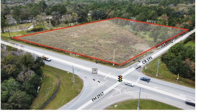
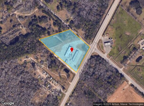
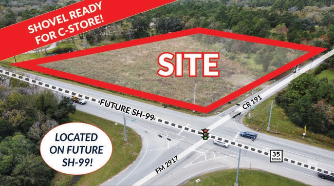
6802 S Highway 35
0037-0037-003
S F Austin
Agriculturalland
A0037 S F AUSTIN TRACT 74A-75H ACRES 5.3681
X
Brazoria
48039C0285K
Texas
2024
5.37 AC
2025
South Hwy 35
6615021037
Houston
9,979 SF
Houston-The Woodlands-Sugar Land, TX
DEMOGRAPHICS near 6802 S Highway 35
1 Mile
3 Mile
5 Mile
2024 Total Population
1,265
4,917
22,601
2029 Population
1,409
5,477
25,149
Pop Growth 2024-2029
+ 11.38%
+ 11.39%
+ 11.27%
Average Age
39
39
38
2024 Total Households
410
1,626
7,958
HH Growth 2024-2029
+ 11.71%
+ 11.50%
+ 11.42%
Median Household Inc
$82,727
$78,337
$66,937
Avg Household Size
2.90
2.90
2.70
2024 Avg HH Vehicles
3.00
3.00
2.00
Median Home Value
$317,796
$294,190
$202,355
Median Year Built
1991
1990
1987
Nearby Places
Map Layers
Map Styles
 Street
 Aerial
- Restaurants
- Banks
- Shops
- Fitness
- Groceries
PUBLIC TRANSPORTATION
AIRPORT
William P Hobby
DRIVE
WALK
Distance
William P Hobby
40 min
23.2 mi
Freight Ports
Port of Houston
DRIVE
WALK
Distance
Port of Houston
51 min
31.4 mi
SALE & LEASE HISTORY
LISTING DATE
SALE/LEASE

Nov 24, 2021
For Sale
Nearby Properties
Address
Land Use
TOTAL SIZE
Lot Size
Zoning
Address
Land Use
TOTAL SIZE
Lot Size
Zoning
64,082 SF
17.62 AC
Address
Land Use
TOTAL SIZE
Lot Size
Zoning
108,386 SF
13 AC
Address
Land Use
TOTAL SIZE
Lot Size
Zoning
39,420 SF
5 AC
Address
Land Use
TOTAL SIZE
Lot Size
Zoning
61,432 SF
25 AC
Address
Land Use
TOTAL SIZE
Lot Size
Zoning
5,100 SF
17.17 AC
Address
Land Use
TOTAL SIZE
Lot Size
Zoning
14,521 SF
54.99 AC
Address
Land Use
TOTAL SIZE
Lot Size
Zoning
374.51 AC
Address
Land Use
TOTAL SIZE
Lot Size
Zoning
10,640 SF
4.97 AC
Address
Land Use
TOTAL SIZE
Lot Size
Zoning
18,800 SF
12.96 AC
Address
Land Use
TOTAL SIZE
Lot Size
Zoning
26,960 SF
59.60 AC
0051
Address
Land Use
TOTAL SIZE
Lot Size
Zoning
18,600 SF
55 AC
0017
Address
Land Use
TOTAL SIZE
Lot Size
Zoning
18,236 SF
16.28 AC
0034
Address
Land Use
TOTAL SIZE
Lot Size
Zoning
15,600 SF
20.12 AC
0015
Address
Land Use
TOTAL SIZE
Lot Size
Zoning
12,160 SF
4 AC
Address
Land Use
TOTAL SIZE
Lot Size
Zoning
16,450 SF
10 AC
0023
Address
Land Use
TOTAL SIZE
Lot Size
Zoning
50.67 AC
Address
Land Use
TOTAL SIZE
Lot Size
Zoning
Address
Land Use
TOTAL SIZE
Lot Size
Zoning
4,310 SF
2.75 AC
Address
Land Use
TOTAL SIZE
Lot Size
Zoning
19.71 AC
0186
Address
Land Use
TOTAL SIZE
Lot Size
Zoning
7,500 SF
12.72 AC
0025
Address
Land Use
TOTAL SIZE
Lot Size
Zoning
512 SF
8.14 AC
0037
Address
Land Use
TOTAL SIZE
Lot Size
Zoning
60.08 AC
0024
Address
Land Use
TOTAL SIZE
Lot Size
Zoning
3,240 SF
14.84 AC
Address
Land Use
TOTAL SIZE
Lot Size
Zoning
26.84 AC
Address
Land Use
TOTAL SIZE
Lot Size
Zoning
9,269 SF
11.84 AC
Address
Land Use
TOTAL SIZE
Lot Size
Zoning
15.23 AC
0193
Address
Land Use
TOTAL SIZE
Lot Size
Zoning
12,400 SF
1.15 AC
Address
Land Use
TOTAL SIZE
Lot Size
Zoning
15.24 AC
Address
Land Use
TOTAL SIZE
Lot Size
Zoning
6,544 SF
2.41 AC
The World's #1 Commercial Real Estate Marketplace
Connect with us
© 2025 CoStar Group
The information above has been obtained from sources believed reliable. While we do not doubt its accuracy we have not verified it and make no guarantee, warranty or representation about it. It is your responsibility to independently confirm its accuracy and completeness. Any projections, opinions, assumptions, or estimates used are for example only and do not represent the current or future performance of the property. The value of this transaction to you depends on tax and other factors which should be evaluated by your tax, financial, and legal advisors. You and your advisors should conduct a careful, independent investigation of the property to determine to your satisfaction the suitability of the property for your needs.