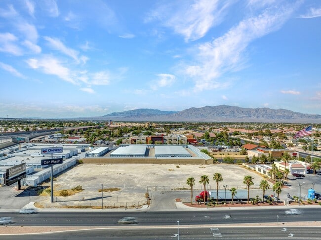
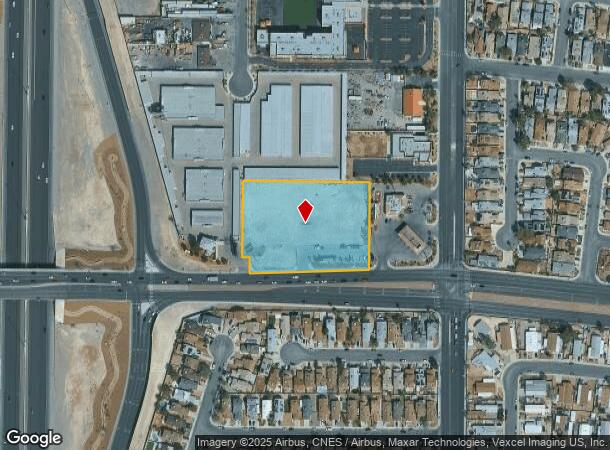
Property Record
6802 W Craig Rd, Las Vegas, NV 89108


NEARBY LISTINGS FOR SALE OR LEASE
Property Detail
6802 W Craig Rd
Las Vegas-Henderson-Paradise, NV
Craig Rainbow
138-03-612-002
CRAIG RAINBOW PLAT BOOK 89 PAGE 10 LOT 2
Commercialnec
Clark
X
Nevada
32003C2155F
2
2025
2.58 AC
2025
Northwest Las Vegas
003426
Las Vegas
DEMOGRAPHICS near 6802 W Craig Rd
1 Mile
3 Mile
5 Mile
2024 Total Population
19,125
144,014
429,382
2029 Population
20,397
153,259
458,852
Pop Growth 2024-2029
+ 6.65%
+ 6.42%
+ 6.86%
Average Age
41
41
40
2024 Total Households
7,525
54,149
156,335
HH Growth 2024-2029
+ 6.67%
+ 6.41%
+ 6.84%
Median Household Inc
$68,522
$68,797
$69,386
Avg Household Size
2.50
2.60
2.70
2024 Avg HH Vehicles
2.00
2.00
2.00
Median Home Value
$340,378
$373,538
$358,207
Median Year Built
1994
1994
1996
Nearby Places
Map Layers
Map Styles
 Street
 Aerial
- Restaurants
- Banks
- Shops
- Fitness
- Groceries
PUBLIC TRANSPORTATION
AIRPORT
Harry Reid International
DRIVE
WALK
Distance
Harry Reid International
26 min
14.0 mi
Boulder City Municipal
DRIVE
WALK
Distance
Boulder City Municipal
46 min
36.5 mi
SALE & LEASE HISTORY
LISTING DATE
SALE/LEASE

Mar 18, 2025
For Sale
Aug 14, 2024
For Lease
Nearby Properties
Address
Land Use
TOTAL SIZE
Lot Size
Zoning
Address
Land Use
TOTAL SIZE
Lot Size
Zoning
647,754 SF
38.57 AC
C2
Address
Land Use
TOTAL SIZE
Lot Size
Zoning
6,386 SF
15.82 AC
Address
Land Use
TOTAL SIZE
Lot Size
Zoning
161.14 AC
CV
Address
Land Use
TOTAL SIZE
Lot Size
Zoning
5,643 SF
10.29 AC
Address
Land Use
TOTAL SIZE
Lot Size
Zoning
37.31 AC
CV
Address
Land Use
TOTAL SIZE
Lot Size
Zoning
7,148 SF
7.26 AC
Address
Land Use
TOTAL SIZE
Lot Size
Zoning
14,793 SF
9.57 AC
CPB
Address
Land Use
TOTAL SIZE
Lot Size
Zoning
346,277 SF
37.61 AC
PUD
Address
Land Use
TOTAL SIZE
Lot Size
Zoning
263,881 SF
7.49 AC
R-4
Address
Land Use
TOTAL SIZE
Lot Size
Zoning
5,750 SF
19.67 AC
R3
Address
Land Use
TOTAL SIZE
Lot Size
Zoning
21.12 AC
RE
Address
Land Use
TOTAL SIZE
Lot Size
Zoning
4,084 SF
1.84 AC
CPB
Address
Land Use
TOTAL SIZE
Lot Size
Zoning
178,800 SF
16.79 AC
TC
Address
Land Use
TOTAL SIZE
Lot Size
Zoning
132,309 SF
12.45 AC
L:T-C
Address
Land Use
TOTAL SIZE
Lot Size
Zoning
3,618 SF
10 AC
L:R-3
Address
Land Use
TOTAL SIZE
Lot Size
Zoning
7,103 SF
14.27 AC
L:R-3
Address
Land Use
TOTAL SIZE
Lot Size
Zoning
17.97 AC
RE
Address
Land Use
TOTAL SIZE
Lot Size
Zoning
105,205 SF
18.86 AC
TC
Address
Land Use
TOTAL SIZE
Lot Size
Zoning
196,873 SF
5.25 AC
C2
Address
Land Use
TOTAL SIZE
Lot Size
Zoning
4,273 SF
16.04 AC
Address
Land Use
TOTAL SIZE
Lot Size
Zoning
4,273 SF
15.06 AC
Address
Land Use
TOTAL SIZE
Lot Size
Zoning
18.02 AC
PF
Address
Land Use
TOTAL SIZE
Lot Size
Zoning
2,006 SF
13.79 AC
RPD20
Address
Land Use
TOTAL SIZE
Lot Size
Zoning
18.93 AC
CV
Address
Land Use
TOTAL SIZE
Lot Size
Zoning
267,271 SF
22.36 AC
C1
Address
Land Use
TOTAL SIZE
Lot Size
Zoning
117,088 SF
5.49 AC
Address
Land Use
TOTAL SIZE
Lot Size
Zoning
9,789 SF
2.10 AC
R3
Address
Land Use
TOTAL SIZE
Lot Size
Zoning
7,427 SF
4.56 AC
R3
Address
Land Use
TOTAL SIZE
Lot Size
Zoning
48,060 SF
7.25 AC
CPB
The World's #1 Commercial Real Estate Marketplace
Connect with us
© 2025 CoStar Group
The information above has been obtained from sources believed reliable. While we do not doubt its accuracy we have not verified it and make no guarantee, warranty or representation about it. It is your responsibility to independently confirm its accuracy and completeness. Any projections, opinions, assumptions, or estimates used are for example only and do not represent the current or future performance of the property. The value of this transaction to you depends on tax and other factors which should be evaluated by your tax, financial, and legal advisors. You and your advisors should conduct a careful, independent investigation of the property to determine to your satisfaction the suitability of the property for your needs.