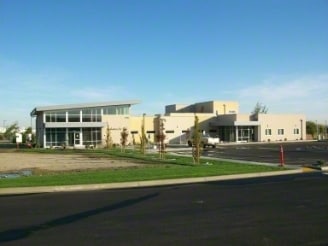
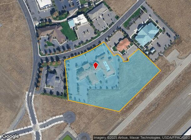
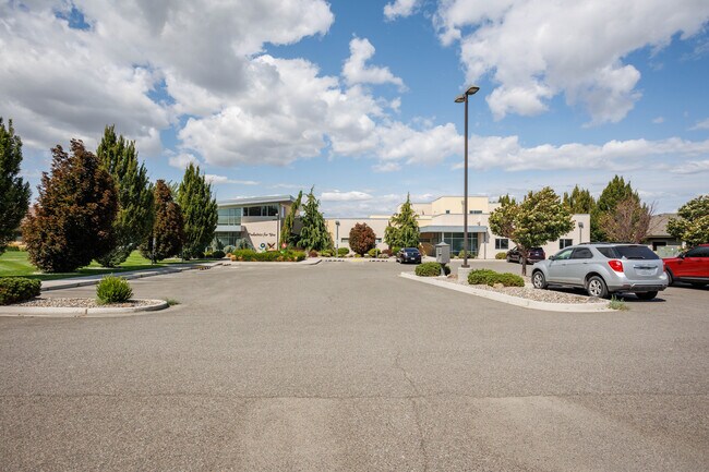
Property Record
6703 W Rio Grande Ave, Kennewick, WA 99336
Current Lease Availabilities
NEARBY LISTINGS FOR SALE OR LEASE
Property Detail
6703 W Rio Grande Ave
Other Market Areas
Binding Site Plan 4436
Kennewick-Richland, WA
SECTION 32, TOWNSHIP 9 NORTH, RANGE 29 EAST, QUARTER NE: BINDING SITE PLAN #4436, LOT 1. RECORDED IN VOLUME 1 OF SURVEYS AT PAGE 4436, RECORDS OF BENTON COUNTY, WASHINGTON. AF#2013-033209, 9/27/2013 VACATED EASEMENT PER AF#2015-003651, 2/09/2015
132991BP4436001
Benton
Commercialnec
Washington
2024
1
2024
7.30 AC
010901
Yakima/Kennewick
32,958 SF
DEMOGRAPHICS near 6703 W Rio Grande Ave
1 Mile
3 Mile
5 Mile
2024 Total Population
6,097
70,943
175,912
2029 Population
6,496
76,425
189,942
Pop Growth 2024-2029
+ 6.54%
+ 7.73%
+ 7.98%
Average Age
39
38
37
2024 Total Households
2,224
27,219
62,699
HH Growth 2024-2029
+ 6.65%
+ 7.77%
+ 8.00%
Median Household Inc
$66,261
$73,750
$79,803
Avg Household Size
2.50
2.60
2.80
2024 Avg HH Vehicles
2.00
2.00
2.00
Median Home Value
$297,258
$352,759
$340,988
Median Year Built
1974
1991
1994
Nearby Places
- Restaurants
- Banks
- Shops
- Fitness
- Groceries
PUBLIC TRANSPORTATION
COMMUTER RAIL
DRIVE
WALK
Distance
15 min
7.8 mi
AIRPORT
Tri-Cities
DRIVE
WALK
Distance
Tri-Cities
14 min
7.8 mi
Nearby Properties
Address
Land Use
TOTAL SIZE
Lot Size
Zoning
Address
Land Use
TOTAL SIZE
Lot Size
Zoning
478,378 SF
25.15 AC
KENNEWICK
Address
Land Use
TOTAL SIZE
Lot Size
Zoning
378,471 SF
16.21 AC
RICHLAND -
Address
Land Use
TOTAL SIZE
Lot Size
Zoning
190,434 SF
47.42 AC
Address
Land Use
TOTAL SIZE
Lot Size
Zoning
232,463 SF
31.54 AC
Address
Land Use
TOTAL SIZE
Lot Size
Zoning
294,855 SF
35.04 AC
KENNEWICK
Address
Land Use
TOTAL SIZE
Lot Size
Zoning
141,940 SF
7.49 AC
Address
Land Use
TOTAL SIZE
Lot Size
Zoning
138,421 SF
31.09 AC
Address
Land Use
TOTAL SIZE
Lot Size
Zoning
238,088 SF
17.06 AC
Address
Land Use
TOTAL SIZE
Lot Size
Zoning
195,749 SF
12.29 AC
35
Address
Land Use
TOTAL SIZE
Lot Size
Zoning
224,114 SF
13.37 AC
Address
Land Use
TOTAL SIZE
Lot Size
Zoning
248,623 SF
12 AC
Address
Land Use
TOTAL SIZE
Lot Size
Zoning
168,650 SF
10.43 AC
KENNEWICK
Address
Land Use
TOTAL SIZE
Lot Size
Zoning
Address
Land Use
TOTAL SIZE
Lot Size
Zoning
179,139 SF
11.79 AC
Address
Land Use
TOTAL SIZE
Lot Size
Zoning
206,208 SF
10.01 AC
KENNEWICK
Address
Land Use
TOTAL SIZE
Lot Size
Zoning
80,622 SF
27.34 AC
Address
Land Use
TOTAL SIZE
Lot Size
Zoning
82,470 SF
12.38 AC
Address
Land Use
TOTAL SIZE
Lot Size
Zoning
200,734 SF
12.38 AC
Address
Land Use
TOTAL SIZE
Lot Size
Zoning
126,589 SF
4.05 AC
Address
Land Use
TOTAL SIZE
Lot Size
Zoning
74,556 SF
1.22 AC
Address
Land Use
TOTAL SIZE
Lot Size
Zoning
144,723 SF
6.88 AC
Address
Land Use
TOTAL SIZE
Lot Size
Zoning
118,412 SF
9.91 AC
KENNEWICK
Address
Land Use
TOTAL SIZE
Lot Size
Zoning
52,900 SF
10.23 AC
Address
Land Use
TOTAL SIZE
Lot Size
Zoning
78,836 SF
13.64 AC
Address
Land Use
TOTAL SIZE
Lot Size
Zoning
127,840 SF
3.69 AC
Address
Land Use
TOTAL SIZE
Lot Size
Zoning
157,320 SF
3.80 AC
53
Address
Land Use
TOTAL SIZE
Lot Size
Zoning
116,283 SF
11.18 AC
RICHLAND -
Address
Land Use
TOTAL SIZE
Lot Size
Zoning
172,573 SF
15.30 AC
Address
Land Use
TOTAL SIZE
Lot Size
Zoning
105,026 SF
8.63 AC
KENNEWICK
Address
Land Use
TOTAL SIZE
Lot Size
Zoning
66,035 SF
15.38 AC
The World's #1 Commercial Real Estate Marketplace
Connect with us
© 2025 CoStar Group
The information above has been obtained from sources believed reliable. While we do not doubt its accuracy we have not verified it and make no guarantee, warranty or representation about it. It is your responsibility to independently confirm its accuracy and completeness. Any projections, opinions, assumptions, or estimates used are for example only and do not represent the current or future performance of the property. The value of this transaction to you depends on tax and other factors which should be evaluated by your tax, financial, and legal advisors. You and your advisors should conduct a careful, independent investigation of the property to determine to your satisfaction the suitability of the property for your needs.