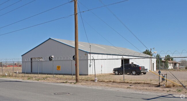
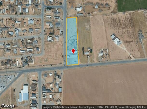
Property Record
681 S Fm 1110, Clint, TX 79836

NEARBY LISTINGS FOR SALE OR LEASE
-
-
View all Clint listings for sale on LoopNet.com
Property Detail
681 S Fm 1110
El Paso, TX
San Elizario
S075-000-019K-0100
19 SAN ELIZARIO 10-A (1.4798 AC) (LESS WATER RIGHT & 9-B-12 (0.6769 AC) (2.1567 AC)
Commercialnec
El Paso
2024
Texas
2025
2.16 AC
010404
Outlying El Paso County
6,000 SF
El Paso
DEMOGRAPHICS near 681 S Fm 1110
1 Mile
3 Mile
5 Mile
2024 Total Population
5,005
27,318
43,310
2029 Population
4,867
27,422
43,647
Pop Growth 2024-2029
(2.76%)
+ 0.38%
+ 0.78%
Average Age
34
35
35
2024 Total Households
1,407
7,894
12,755
HH Growth 2024-2029
(2.63%)
+ 0.29%
+ 0.70%
Median Household Inc
$38,573
$41,818
$41,737
Avg Household Size
3.50
3.40
3.40
2024 Avg HH Vehicles
2.00
2.00
2.00
Median Home Value
$93,450
$113,369
$114,541
Median Year Built
1994
1997
1995
Nearby Places
Map Layers
Map Styles
 Street
 Aerial
- Restaurants
- Banks
- Shops
- Fitness
- Groceries
PUBLIC TRANSPORTATION
AIRPORT
El Paso International
DRIVE
WALK
Distance
El Paso International
41 min
22.1 mi
Freight Ports
Port of Corpus Christi
DRIVE
WALK
Distance
Port of Corpus Christi
662 min
676.7 mi
Nearby Properties
Address
Land Use
TOTAL SIZE
Lot Size
Zoning
Address
Land Use
TOTAL SIZE
Lot Size
Zoning
953,000 SF
45.97 AC
M2
Address
Land Use
TOTAL SIZE
Lot Size
Zoning
209,935 SF
45.09 AC
Address
Land Use
TOTAL SIZE
Lot Size
Zoning
618,222 SF
25.18 AC
M2
Address
Land Use
TOTAL SIZE
Lot Size
Zoning
450,900 SF
20.46 AC
M2
Address
Land Use
TOTAL SIZE
Lot Size
Zoning
131,564 SF
18.62 AC
Address
Land Use
TOTAL SIZE
Lot Size
Zoning
130,100 SF
41.51 AC
Address
Land Use
TOTAL SIZE
Lot Size
Zoning
107,280 SF
20.64 AC
Address
Land Use
TOTAL SIZE
Lot Size
Zoning
293,760 SF
15.59 AC
Address
Land Use
TOTAL SIZE
Lot Size
Zoning
293,760 SF
16.87 AC
Address
Land Use
TOTAL SIZE
Lot Size
Zoning
117,512 SF
20.84 AC
Address
Land Use
TOTAL SIZE
Lot Size
Zoning
101,412 SF
42.51 AC
Address
Land Use
TOTAL SIZE
Lot Size
Zoning
138,279 SF
17.42 AC
Address
Land Use
TOTAL SIZE
Lot Size
Zoning
242,991 SF
8.81 AC
M2
Address
Land Use
TOTAL SIZE
Lot Size
Zoning
1 SF
Address
Land Use
TOTAL SIZE
Lot Size
Zoning
58,002 SF
4.97 AC
Address
Land Use
TOTAL SIZE
Lot Size
Zoning
259,200 SF
16.09 AC
Address
Land Use
TOTAL SIZE
Lot Size
Zoning
72,444 SF
3.77 AC
Address
Land Use
TOTAL SIZE
Lot Size
Zoning
41,527 SF
15.66 AC
Address
Land Use
TOTAL SIZE
Lot Size
Zoning
19,805 SF
2.66 AC
Address
Land Use
TOTAL SIZE
Lot Size
Zoning
38,755 SF
8.42 AC
Address
Land Use
TOTAL SIZE
Lot Size
Zoning
14,688 SF
2.34 AC
Address
Land Use
TOTAL SIZE
Lot Size
Zoning
54,675 SF
3.24 AC
Address
Land Use
TOTAL SIZE
Lot Size
Zoning
16,881 SF
7.35 AC
Address
Land Use
TOTAL SIZE
Lot Size
Zoning
81,077 SF
8.49 AC
NZ
Address
Land Use
TOTAL SIZE
Lot Size
Zoning
21,130 SF
2.30 AC
Address
Land Use
TOTAL SIZE
Lot Size
Zoning
90,714 SF
8.17 AC
NZ
Address
Land Use
TOTAL SIZE
Lot Size
Zoning
56,478 SF
6.49 AC
Address
Land Use
TOTAL SIZE
Lot Size
Zoning
13,440 SF
2 AC
Address
Land Use
TOTAL SIZE
Lot Size
Zoning
73,856 SF
8.64 AC
Address
Land Use
TOTAL SIZE
Lot Size
Zoning
81,570 SF
7.21 AC
NZ
The World's #1 Commercial Real Estate Marketplace
Connect with us
© 2025 CoStar Group
The information above has been obtained from sources believed reliable. While we do not doubt its accuracy we have not verified it and make no guarantee, warranty or representation about it. It is your responsibility to independently confirm its accuracy and completeness. Any projections, opinions, assumptions, or estimates used are for example only and do not represent the current or future performance of the property. The value of this transaction to you depends on tax and other factors which should be evaluated by your tax, financial, and legal advisors. You and your advisors should conduct a careful, independent investigation of the property to determine to your satisfaction the suitability of the property for your needs.