Property Record
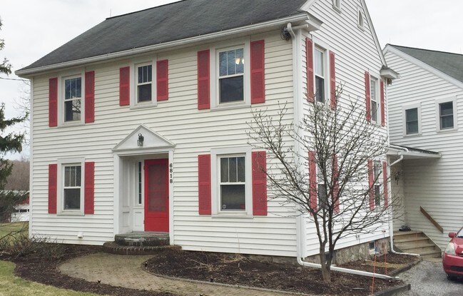
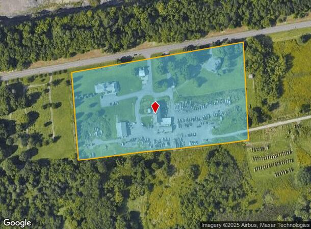
6810 E Seneca Tpke, Jamesville, NY 13078
NEARBY LISTINGS FOR SALE OR LEASE
-
-
View all Jamesville listings for lease on LoopNet.com
Property Detail
6810 E Seneca Tpke
312689-089-000-0001-005-003-0000
Onondaga
Multifamilydwelling
New York
X
5.003
36067C0356F
11.94 AC
2025
SE Outer Onondaga County
2024
Syracuse
014900
Syracuse, NY
400 SF
DEMOGRAPHICS near 6810 E Seneca Tpke
1 Mile
3 Mile
5 Mile
2024 Total Population
219
14,686
79,154
2029 Population
211
14,301
77,397
Pop Growth 2024-2029
(3.65%)
(2.62%)
(2.22%)
Average Age
43
45
41
2024 Total Households
77
5,825
31,426
HH Growth 2024-2029
(3.90%)
(2.80%)
(2.34%)
Median Household Inc
$116,666
$111,910
$74,034
Avg Household Size
2.60
2.40
2.30
2024 Avg HH Vehicles
2.00
2.00
2.00
Median Home Value
$283,333
$277,628
$224,743
Median Year Built
1979
1971
1963
Nearby Places
Map Layers
Map Styles
 Street
 Aerial
- Restaurants
- Banks
- Shops
- Fitness
- Groceries
PUBLIC TRANSPORTATION
AIRPORT
Syracuse Hancock International
DRIVE
WALK
Distance
Syracuse Hancock International
26 min
15.3 mi
Freight Ports
Albany, NY Port
DRIVE
WALK
Distance
Albany, NY Port
176 min
140.8 mi
SALE & LEASE HISTORY
LISTING DATE
SALE/LEASE

Dec 13, 2016
For Lease
Nearby Properties
Address
Land Use
TOTAL SIZE
Lot Size
Zoning
Address
Land Use
TOTAL SIZE
Lot Size
Zoning
25,646 SF
88.85 AC
02 - SINGL
Address
Land Use
TOTAL SIZE
Lot Size
Zoning
44,100 SF
165.64 AC
08 - GOVER
Address
Land Use
TOTAL SIZE
Lot Size
Zoning
4,722 SF
35.39 AC
R5
Address
Land Use
TOTAL SIZE
Lot Size
Zoning
163,518 SF
19.24 AC
07 - MIXED
Address
Land Use
TOTAL SIZE
Lot Size
Zoning
25,050 SF
19.04 AC
07 - MIXED
Address
Land Use
TOTAL SIZE
Lot Size
Zoning
6,500 SF
1,397.41 AC
07 - MIXED
Address
Land Use
TOTAL SIZE
Lot Size
Zoning
165,568 SF
75.80 AC
02 - SINGL
Address
Land Use
TOTAL SIZE
Lot Size
Zoning
101,950 SF
7.32 AC
R2
Address
Land Use
TOTAL SIZE
Lot Size
Zoning
81,970 SF
29.34 AC
07 - MIXED
Address
Land Use
TOTAL SIZE
Lot Size
Zoning
24,420 SF
6.71 AC
Address
Land Use
TOTAL SIZE
Lot Size
Zoning
29,528 SF
190.15 AC
02 - SINGL
Address
Land Use
TOTAL SIZE
Lot Size
Zoning
62,188 SF
20.24 AC
R1
Address
Land Use
TOTAL SIZE
Lot Size
Zoning
13,660 SF
5.58 AC
06 - INDUS
Address
Land Use
TOTAL SIZE
Lot Size
Zoning
43,960 SF
3.64 AC
07 - MIXED
Address
Land Use
TOTAL SIZE
Lot Size
Zoning
9.35 AC
02 - SINGL
Address
Land Use
TOTAL SIZE
Lot Size
Zoning
219.38 AC
04 - FARM
Address
Land Use
TOTAL SIZE
Lot Size
Zoning
9,560 SF
282.73 AC
07 - MIXED
Address
Land Use
TOTAL SIZE
Lot Size
Zoning
9,248 SF
3.88 AC
05 - COMME
Address
Land Use
TOTAL SIZE
Lot Size
Zoning
18,210 SF
8.80 AC
R1
Address
Land Use
TOTAL SIZE
Lot Size
Zoning
17,122 SF
3.92 AC
07 - MIXED
Address
Land Use
TOTAL SIZE
Lot Size
Zoning
980 SF
16.03 AC
05 - COMME
Address
Land Use
TOTAL SIZE
Lot Size
Zoning
21,010 SF
4.63 AC
05 - COMME
Address
Land Use
TOTAL SIZE
Lot Size
Zoning
26,144 SF
11.64 AC
04 - FARM
Address
Land Use
TOTAL SIZE
Lot Size
Zoning
2,473 SF
104.29 AC
RA
Address
Land Use
TOTAL SIZE
Lot Size
Zoning
10,792 SF
6.22 AC
02 - SINGL
Address
Land Use
TOTAL SIZE
Lot Size
Zoning
38,258 SF
23.66 AC
02 - SINGL
Address
Land Use
TOTAL SIZE
Lot Size
Zoning
11,569 SF
1.46 AC
02 - SINGL
Address
Land Use
TOTAL SIZE
Lot Size
Zoning
8,101 SF
4.53 AC
C
Address
Land Use
TOTAL SIZE
Lot Size
Zoning
3.78 AC
02 - SINGL
Address
Land Use
TOTAL SIZE
Lot Size
Zoning
2.73 AC
02 - SINGL
The World's #1 Commercial Real Estate Marketplace
Connect with us
© 2026 CoStar Group
The information above has been obtained from sources believed reliable. While we do not doubt its accuracy we have not verified it and make no guarantee, warranty or representation about it. It is your responsibility to independently confirm its accuracy and completeness. Any projections, opinions, assumptions, or estimates used are for example only and do not represent the current or future performance of the property. The value of this transaction to you depends on tax and other factors which should be evaluated by your tax, financial, and legal advisors. You and your advisors should conduct a careful, independent investigation of the property to determine to your satisfaction the suitability of the property for your needs.