Property Record
6812 Kitsap Way, Bremerton, WA 98312
NEARBY LISTINGS FOR SALE OR LEASE
Property Detail
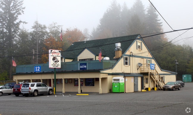
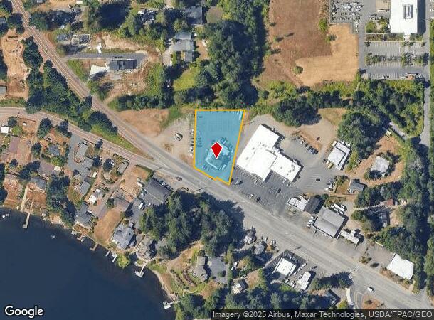
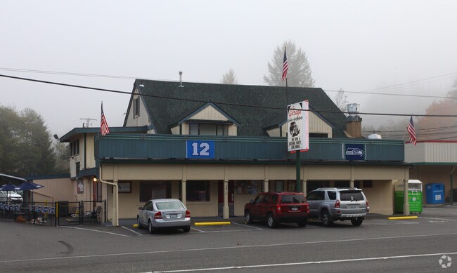
6812 Kitsap Way
Bremerton-Silverdale, WA
Lake Kitsap Summer Homes
3765-000-014-02-01
THAT PORTION OF LOT 14, LAKE KITSAP SUMMER HOMES ACCORDING TO PLAT RECORDED IN VOLUME 3 OF PLATS, PAGE 94, IN KITSAP COUNTY, WASHINGTON, LYING EASTERLY OF FENCE ESTABLISHED IN KITSAP COUNTY SUPERIOR COURT CASE NO. 20136, BEING APPROXIMATELY THE EASTE
Bartavern
Kitsap
X
Washington
53035C0354F
14
2025
0.91 AC
2026
West Kitsap County
080900
Bremerton/Silverdale
648 SF
DEMOGRAPHICS near 6812 Kitsap Way
1 Mile
3 Mile
5 Mile
2024 Total Population
4,527
31,486
96,623
2029 Population
4,556
32,138
98,135
Pop Growth 2024-2029
+ 0.64%
+ 2.07%
+ 1.56%
Average Age
36
39
39
2024 Total Households
1,681
12,796
36,883
HH Growth 2024-2029
+ 0.59%
+ 2.19%
+ 1.73%
Median Household Inc
$71,305
$65,859
$70,289
Avg Household Size
2.60
2.30
2.40
2024 Avg HH Vehicles
2.00
2.00
2.00
Median Home Value
$448,756
$385,787
$393,233
Median Year Built
1978
1973
1978
Nearby Places
Map Layers
Map Styles
 Street
 Aerial
- Restaurants
- Banks
- Shops
- Fitness
- Groceries
PUBLIC TRANSPORTATION
AIRPORT
Seattle Paine Field International
DRIVE
WALK
Distance
Seattle Paine Field International
112 min
45.0 mi
Freight Ports
Port of Seattle
DRIVE
WALK
Distance
Port of Seattle
76 min
26.8 mi
Nearby Properties
Address
Land Use
TOTAL SIZE
Lot Size
Zoning
Address
Land Use
TOTAL SIZE
Lot Size
Zoning
21,408 SF
8.26 AC
BVSAP
Address
Land Use
TOTAL SIZE
Lot Size
Zoning
138,877 SF
7.17 AC
R-10
Address
Land Use
TOTAL SIZE
Lot Size
Zoning
66,022 SF
8.28 AC
RR
Address
Land Use
TOTAL SIZE
Lot Size
Zoning
112,847 SF
6.80 AC
UM
Address
Land Use
TOTAL SIZE
Lot Size
Zoning
Address
Land Use
TOTAL SIZE
Lot Size
Zoning
75,390 SF
4.46 AC
R-18
Address
Land Use
TOTAL SIZE
Lot Size
Zoning
68,079 SF
2.16 AC
BVSAP
Address
Land Use
TOTAL SIZE
Lot Size
Zoning
73,931 SF
11.72 AC
FC
Address
Land Use
TOTAL SIZE
Lot Size
Zoning
43,944 SF
2.64 AC
FC
Address
Land Use
TOTAL SIZE
Lot Size
Zoning
45,682 SF
2.04 AC
GC
Address
Land Use
TOTAL SIZE
Lot Size
Zoning
75,225 SF
3.30 AC
R-10
Address
Land Use
TOTAL SIZE
Lot Size
Zoning
55,866 SF
8.48 AC
FC
Address
Land Use
TOTAL SIZE
Lot Size
Zoning
48,520 SF
3.76 AC
GC
Address
Land Use
TOTAL SIZE
Lot Size
Zoning
44,220 SF
2.86 AC
R-40
Address
Land Use
TOTAL SIZE
Lot Size
Zoning
52,461 SF
5.92 AC
RR
Address
Land Use
TOTAL SIZE
Lot Size
Zoning
42,665 SF
5.55 AC
FC
Address
Land Use
TOTAL SIZE
Lot Size
Zoning
52,601 SF
6.30 AC
BVSAP
Address
Land Use
TOTAL SIZE
Lot Size
Zoning
47,064 SF
5.27 AC
GC
Address
Land Use
TOTAL SIZE
Lot Size
Zoning
74,169 SF
2.62 AC
GC
Address
Land Use
TOTAL SIZE
Lot Size
Zoning
34,792 SF
1.89 AC
R-10
Address
Land Use
TOTAL SIZE
Lot Size
Zoning
46,395 SF
2.41 AC
FC
Address
Land Use
TOTAL SIZE
Lot Size
Zoning
28,982 SF
1.90 AC
GC
Address
Land Use
TOTAL SIZE
Lot Size
Zoning
1,508 SF
1.84 AC
R-10
Address
Land Use
TOTAL SIZE
Lot Size
Zoning
40,131 SF
4.90 AC
FC
Address
Land Use
TOTAL SIZE
Lot Size
Zoning
2.31 AC
CITY
Address
Land Use
TOTAL SIZE
Lot Size
Zoning
36,094 SF
2.84 AC
FC
Address
Land Use
TOTAL SIZE
Lot Size
Zoning
30,367 SF
4.55 AC
FC
Address
Land Use
TOTAL SIZE
Lot Size
Zoning
29,694 SF
0.72 AC
R-10
Address
Land Use
TOTAL SIZE
Lot Size
Zoning
26,752 SF
1.92 AC
R-10
Address
Land Use
TOTAL SIZE
Lot Size
Zoning
38,580 SF
2.44 AC
I
The World's #1 Commercial Real Estate Marketplace
Connect with us
© 2025 CoStar Group
The information above has been obtained from sources believed reliable. While we do not doubt its accuracy we have not verified it and make no guarantee, warranty or representation about it. It is your responsibility to independently confirm its accuracy and completeness. Any projections, opinions, assumptions, or estimates used are for example only and do not represent the current or future performance of the property. The value of this transaction to you depends on tax and other factors which should be evaluated by your tax, financial, and legal advisors. You and your advisors should conduct a careful, independent investigation of the property to determine to your satisfaction the suitability of the property for your needs.