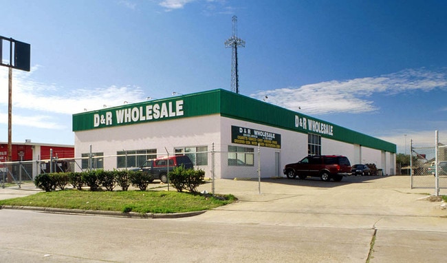
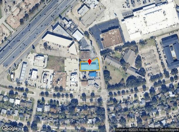
Property Record
6816 Larkwood Dr, Houston, TX 77074
Current Lease Availabilities
NEARBY LISTINGS FOR SALE OR LEASE
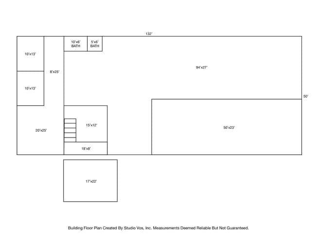
Property Detail
6816 Larkwood Dr
0930280000008
Sharpstown Ind Park Sec 8
Warehouse
TR 1C-1 BLK 23 SHARPSTOWN IND PARK SEC 8
X
Harris
48157C0175L
Texas
2024
0.56 AC
2025
Hwy 59/Hwy 90 (Alt)
421302
Houston
9,672 SF
Houston-The Woodlands-Sugar Land, TX
DEMOGRAPHICS near 6816 Larkwood Dr
1 Mile
3 Mile
5 Mile
2024 Total Population
30,980
273,979
589,401
2029 Population
31,979
281,814
605,509
Pop Growth 2024-2029
+ 3.22%
+ 2.86%
+ 2.73%
Average Age
35
35
37
2024 Total Households
11,043
107,049
239,209
HH Growth 2024-2029
+ 3.31%
+ 2.82%
+ 2.77%
Median Household Inc
$39,233
$40,447
$53,439
Avg Household Size
2.60
2.50
2.40
2024 Avg HH Vehicles
1.00
1.00
2.00
Median Home Value
$162,812
$280,438
$353,796
Median Year Built
1974
1976
1980
Nearby Places
Map Layers
Map Styles
 Street
 Aerial
- Restaurants
- Banks
- Shops
- Fitness
- Groceries
PUBLIC TRANSPORTATION
AIRPORT
William P Hobby
DRIVE
WALK
Distance
William P Hobby
34 min
20.9 mi
George Bush Intcntl/Houston
DRIVE
WALK
Distance
George Bush Intcntl/Houston
39 min
29.5 mi
Freight Ports
Port of Houston
DRIVE
WALK
Distance
Port of Houston
30 min
20.2 mi
Nearby Properties
Address
Land Use
TOTAL SIZE
Lot Size
Zoning
Address
Land Use
TOTAL SIZE
Lot Size
Zoning
1,202,191 SF
39.08 AC
Address
Land Use
TOTAL SIZE
Lot Size
Zoning
1,612,349 SF
54.03 AC
Address
Land Use
TOTAL SIZE
Lot Size
Zoning
507,252 SF
5.93 AC
Address
Land Use
TOTAL SIZE
Lot Size
Zoning
972,984 SF
30.18 AC
Address
Land Use
TOTAL SIZE
Lot Size
Zoning
417,988 SF
15.70 AC
Address
Land Use
TOTAL SIZE
Lot Size
Zoning
361,954 SF
14.43 AC
Address
Land Use
TOTAL SIZE
Lot Size
Zoning
807,423 SF
30.01 AC
Address
Land Use
TOTAL SIZE
Lot Size
Zoning
812,087 SF
28.58 AC
Address
Land Use
TOTAL SIZE
Lot Size
Zoning
649,992 SF
19.81 AC
Address
Land Use
TOTAL SIZE
Lot Size
Zoning
413,734 SF
6.22 AC
Address
Land Use
TOTAL SIZE
Lot Size
Zoning
188,178 SF
18.49 AC
Address
Land Use
TOTAL SIZE
Lot Size
Zoning
769,005 SF
20.46 AC
Address
Land Use
TOTAL SIZE
Lot Size
Zoning
1,008,102 SF
3.54 AC
Address
Land Use
TOTAL SIZE
Lot Size
Zoning
544,698 SF
15.66 AC
Address
Land Use
TOTAL SIZE
Lot Size
Zoning
383,540 SF
4.43 AC
Address
Land Use
TOTAL SIZE
Lot Size
Zoning
598,127 SF
4.14 AC
Address
Land Use
TOTAL SIZE
Lot Size
Zoning
340,136 SF
13.34 AC
Address
Land Use
TOTAL SIZE
Lot Size
Zoning
539,308 SF
21 AC
Address
Land Use
TOTAL SIZE
Lot Size
Zoning
445,720 SF
4.26 AC
Address
Land Use
TOTAL SIZE
Lot Size
Zoning
473,207 SF
15.50 AC
Address
Land Use
TOTAL SIZE
Lot Size
Zoning
360,715 SF
4.04 AC
Address
Land Use
TOTAL SIZE
Lot Size
Zoning
409,371 SF
8.67 AC
Address
Land Use
TOTAL SIZE
Lot Size
Zoning
450,980 SF
4.89 AC
Address
Land Use
TOTAL SIZE
Lot Size
Zoning
768,015 SF
17.98 AC
Address
Land Use
TOTAL SIZE
Lot Size
Zoning
376,860 SF
12.42 AC
Address
Land Use
TOTAL SIZE
Lot Size
Zoning
450,314 SF
10.81 AC
Address
Land Use
TOTAL SIZE
Lot Size
Zoning
493,494 SF
13.54 AC
Address
Land Use
TOTAL SIZE
Lot Size
Zoning
394,544 SF
2.62 AC
Address
Land Use
TOTAL SIZE
Lot Size
Zoning
165,703 SF
15.96 AC
Address
Land Use
TOTAL SIZE
Lot Size
Zoning
481,176 SF
18.15 AC
The World's #1 Commercial Real Estate Marketplace
Connect with us
© 2025 CoStar Group
The information above has been obtained from sources believed reliable. While we do not doubt its accuracy we have not verified it and make no guarantee, warranty or representation about it. It is your responsibility to independently confirm its accuracy and completeness. Any projections, opinions, assumptions, or estimates used are for example only and do not represent the current or future performance of the property. The value of this transaction to you depends on tax and other factors which should be evaluated by your tax, financial, and legal advisors. You and your advisors should conduct a careful, independent investigation of the property to determine to your satisfaction the suitability of the property for your needs.