Property Record
68200 33Rd Ave, Cathedral City, CA 92234
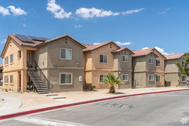


Property Detail
68200 33Rd Ave
680-340-007
21.69 ACRES M/L IN LOT 162 MB 025/061 PALM SPRINGS OUTPOST 2 AND POR PAR B AND PARS C & 3 PM 157/073 PM 23865 AND POR NW 1/4 OF SEC 21 T4S R5E FOR TOTAL DESCRIPTION SEE ASSESSORS MAPS
Apartment
Riverside
R2-B
California
AE The base floodplain where base flood elevations are provided. AE Zones are now used on new format FIRMs instead of A1-A30 Zones.
162
2024
21.69 AC
2025
Coachella Valley
044907
Inland Empire (California)
73,256 SF
Riverside-San Bernardino-Ontario, CA
NEARBY LISTINGS FOR SALE OR LEASE
DEMOGRAPHICS near 68200 33Rd Ave
1 mile
3 mile
5 mile
2025 Total Population
18,196
82,113
137,315
2030 Population
18,886
87,223
147,131
Pop Growth 2025-2030
+ 3.79%
+ 6.22%
+ 7.15%
Average Age
39
47
50
2025 Total Households
5,933
34,078
62,651
HH Growth 2025-2030
+ 4.40%
+ 6.97%
+ 7.72%
Median Household Inc
$56,037
$72,932
$80,255
Avg Household Size
3.00
2.30
2.10
2025 Avg HH Vehicles
2.00
2.00
2.00
Median Home Value
$419,603
$601,758
$675,604
Median Year Built
1984
1986
1984
Nearby Places
Map Layers
Map Styles
 Street
 Aerial
Layers
 Traffic
 Biking
Places
Listings with unknown addresses are not visible on the map
- Restaurants
- Banks
- Shops
- Fitness
- Groceries
PUBLIC TRANSPORTATION
AIRPORT
Palm Springs International
Drive
Walk
Distance
Palm Springs International
9 min
3.5 mi
Freight Ports
Port of San Diego
Drive
Walk
Distance
Port of San Diego
162 min
132.2 mi
Nearby Properties
Address
Land Use
TOTAL SIZE
Lot Size
Zoning
Address
Land Use
TOTAL SIZE
Lot Size
Zoning
91,939 SF
8.80 AC
Address
Land Use
TOTAL SIZE
Lot Size
Zoning
35,188 SF
5.98 AC
R3
Address
Land Use
TOTAL SIZE
Lot Size
Zoning
225,833 SF
22 AC
Address
Land Use
TOTAL SIZE
Lot Size
Zoning
208,000 SF
16.04 AC
Address
Land Use
TOTAL SIZE
Lot Size
Zoning
129,852 SF
11.17 AC
Address
Land Use
TOTAL SIZE
Lot Size
Zoning
5,509 SF
10.06 AC
PCC
Address
Land Use
TOTAL SIZE
Lot Size
Zoning
120,754 SF
14.30 AC
Address
Land Use
TOTAL SIZE
Lot Size
Zoning
322,000 SF
19.09 AC
Address
Land Use
TOTAL SIZE
Lot Size
Zoning
3.20 AC
GR5
Address
Land Use
TOTAL SIZE
Lot Size
Zoning
31,488 SF
3.40 AC
A
Address
Land Use
TOTAL SIZE
Lot Size
Zoning
133,920 SF
8.26 AC
R1
Address
Land Use
TOTAL SIZE
Lot Size
Zoning
114,044 SF
5.40 AC
R3
Address
Land Use
TOTAL SIZE
Lot Size
Zoning
Address
Land Use
TOTAL SIZE
Lot Size
Zoning
53,229 SF
8.80 AC
Address
Land Use
TOTAL SIZE
Lot Size
Zoning
41,962 SF
5 AC
Address
Land Use
TOTAL SIZE
Lot Size
Zoning
38,388 SF
8.31 AC
R3
Address
Land Use
TOTAL SIZE
Lot Size
Zoning
103,526 SF
11.40 AC
Address
Land Use
TOTAL SIZE
Lot Size
Zoning
238,554 SF
13.31 AC
R1
Address
Land Use
TOTAL SIZE
Lot Size
Zoning
81,687 SF
4.97 AC
R3
Address
Land Use
TOTAL SIZE
Lot Size
Zoning
176,519 SF
12.60 AC
Address
Land Use
TOTAL SIZE
Lot Size
Zoning
Address
Land Use
TOTAL SIZE
Lot Size
Zoning
93,044 SF
5.81 AC
Address
Land Use
TOTAL SIZE
Lot Size
Zoning
60,280 SF
5.51 AC
R3
Address
Land Use
TOTAL SIZE
Lot Size
Zoning
124,636 SF
10.63 AC
Address
Land Use
TOTAL SIZE
Lot Size
Zoning
125,635 SF
4.75 AC
Address
Land Use
TOTAL SIZE
Lot Size
Zoning
66,732 SF
1.80 AC
PCC
Address
Land Use
TOTAL SIZE
Lot Size
Zoning
6,717 SF
17.79 AC
Address
Land Use
TOTAL SIZE
Lot Size
Zoning
157,093 SF
9.86 AC
R3
The World's #1 Commercial Real Estate Marketplace
Connect with us
© 2026 CoStar Group
The information above has been obtained from sources believed reliable. While we do not doubt its accuracy we have not verified it and make no guarantee, warranty or representation about it. It is your responsibility to independently confirm its accuracy and completeness. Any projections, opinions, assumptions, or estimates used are for example only and do not represent the current or future performance of the property. The value of this transaction to you depends on tax and other factors which should be evaluated by your tax, financial, and legal advisors. You and your advisors should conduct a careful, independent investigation of the property to determine to your satisfaction the suitability of the property for your needs.