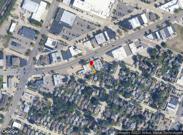
Property Record
6821 Allen Rd, Allen Park, MI 48101
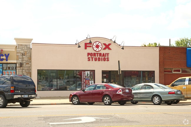

This Property Is For Sale
NEARBY LISTINGS FOR SALE OR LEASE
Property Detail
6821 Allen Rd
Detroit-Warren-Dearborn, MI
Lincolnlawn
30-012-03-0034-000
A84A34 LOT 34 LINCOLNLAWN SUB PC 84,86,95 L53 P62 WCR
Officebuilding
Wayne
X
Michigan
26163C0264E
34
2024
0.05 AC
2025
Downriver South
576400
Detroit
1,560 SF
DEMOGRAPHICS near 6821 Allen Rd
1 Mile
3 Mile
5 Mile
2024 Total Population
14,872
123,482
265,958
2029 Population
14,197
118,505
255,788
Pop Growth 2024-2029
(4.54%)
(4.03%)
(3.82%)
Average Age
41
40
40
2024 Total Households
6,023
49,180
106,695
HH Growth 2024-2029
(4.62%)
(4.05%)
(3.82%)
Median Household Inc
$71,423
$59,936
$58,581
Avg Household Size
2.40
2.50
2.40
2024 Avg HH Vehicles
2.00
2.00
2.00
Median Home Value
$154,682
$137,794
$144,387
Median Year Built
1953
1955
1955
Nearby Places
Map Layers
Map Styles
 Street
 Aerial
- Restaurants
- Banks
- Shops
- Fitness
- Groceries
PUBLIC TRANSPORTATION
AIRPORT
Detroit Metro Wayne County
DRIVE
WALK
Distance
Detroit Metro Wayne County
20 min
14.1 mi
Detroit City
DRIVE
WALK
Distance
Detroit City
26 min
18.3 mi
Freight Ports
Port of Baltimore
DRIVE
WALK
Distance
Port of Baltimore
1 min
403.1 mi
Nearby Properties
Address
Land Use
TOTAL SIZE
Lot Size
Zoning
Address
Land Use
TOTAL SIZE
Lot Size
Zoning
675,440 SF
66.32 AC
IB
Address
Land Use
TOTAL SIZE
Lot Size
Zoning
1,209,711 SF
69.44 AC
IB
Address
Land Use
TOTAL SIZE
Lot Size
Zoning
590,893 SF
51.81 AC
IB
Address
Land Use
TOTAL SIZE
Lot Size
Zoning
229,368 SF
1 AC
C 6A
Address
Land Use
TOTAL SIZE
Lot Size
Zoning
357,640 SF
13.89 AC
C 6C
Address
Land Use
TOTAL SIZE
Lot Size
Zoning
349,045 SF
40.28 AC
IB
Address
Land Use
TOTAL SIZE
Lot Size
Zoning
135,775 SF
18.39 AC
BC
Address
Land Use
TOTAL SIZE
Lot Size
Zoning
492,289 SF
34.84 AC
RM-1
Address
Land Use
TOTAL SIZE
Lot Size
Zoning
108,960 SF
5.23 AC
OS
Address
Land Use
TOTAL SIZE
Lot Size
Zoning
678,368 SF
48.99 AC
RD RESEARC
Address
Land Use
TOTAL SIZE
Lot Size
Zoning
219,434 SF
23.91 AC
BC
Address
Land Use
TOTAL SIZE
Lot Size
Zoning
Address
Land Use
TOTAL SIZE
Lot Size
Zoning
107,772 SF
8 AC
BC
Address
Land Use
TOTAL SIZE
Lot Size
Zoning
32,608 SF
46.51 AC
BC
Address
Land Use
TOTAL SIZE
Lot Size
Zoning
77,974 SF
1 AC
C 6A
Address
Land Use
TOTAL SIZE
Lot Size
Zoning
3,261 SF
23.39 AC
RM MULTI F
Address
Land Use
TOTAL SIZE
Lot Size
Zoning
205,632 SF
1 AC
C 6A
Address
Land Use
TOTAL SIZE
Lot Size
Zoning
169,200 SF
19.92 AC
RD RESEARC
Address
Land Use
TOTAL SIZE
Lot Size
Zoning
637,176 SF
39.11 AC
C 6C
Address
Land Use
TOTAL SIZE
Lot Size
Zoning
287,791 SF
17.98 AC
RM MULTI F
Address
Land Use
TOTAL SIZE
Lot Size
Zoning
163,944 SF
17.51 AC
RM MULTI F
Address
Land Use
TOTAL SIZE
Lot Size
Zoning
356,200 SF
21.66 AC
I-2
Address
Land Use
TOTAL SIZE
Lot Size
Zoning
912 SF
2.80 AC
RM MULTI F
Address
Land Use
TOTAL SIZE
Lot Size
Zoning
219,144 SF
24.53 AC
B-2
Address
Land Use
TOTAL SIZE
Lot Size
Zoning
111,402 SF
3.17 AC
Address
Land Use
TOTAL SIZE
Lot Size
Zoning
182,840 SF
11.70 AC
C 6C
Address
Land Use
TOTAL SIZE
Lot Size
Zoning
415,606 SF
18.75 AC
I-1
Address
Land Use
TOTAL SIZE
Lot Size
Zoning
193,650 SF
18.39 AC
Address
Land Use
TOTAL SIZE
Lot Size
Zoning
98,356 SF
7.83 AC
B-2
Address
Land Use
TOTAL SIZE
Lot Size
Zoning
180,986 SF
7.02 AC
I-1
The World's #1 Commercial Real Estate Marketplace
Connect with us
© 2025 CoStar Group
The information above has been obtained from sources believed reliable. While we do not doubt its accuracy we have not verified it and make no guarantee, warranty or representation about it. It is your responsibility to independently confirm its accuracy and completeness. Any projections, opinions, assumptions, or estimates used are for example only and do not represent the current or future performance of the property. The value of this transaction to you depends on tax and other factors which should be evaluated by your tax, financial, and legal advisors. You and your advisors should conduct a careful, independent investigation of the property to determine to your satisfaction the suitability of the property for your needs.