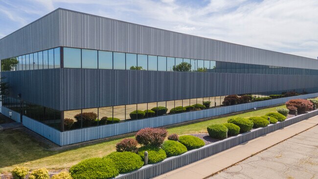
Property Record
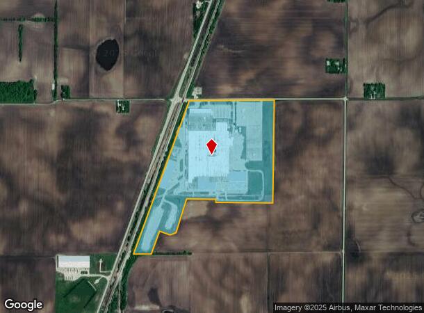
6821 E County Road 1100N N, Mattoon, IL 61938
Current Lease Availabilities
NEARBY LISTINGS FOR SALE OR LEASE
-
-
View all Mattoon listings for lease on LoopNet.com
Property Detail
6821 E County Road 1100N N
04-0-01019-001
Illinois Central Railroad Company
Industrialgeneral
SEC 31 T13N R8E N1/2 EAST OF ICRR EX: 73.76A OFF THE EAST SIDE (#0711052) ALSO EX: 38.03A OFF THE SOUTH SIDE (#0730441)
X
Coles
17029C0175D
Illinois
2024
83.61 AC
2024
Effingham/Central Illinois Area
001100
Other Market Areas
24,888 SF
Charleston-Mattoon, IL
DEMOGRAPHICS near 6821 E County Road 1100N N
1 Mile
3 Mile
5 Mile
2024 Total Population
371
958
17,698
2029 Population
355
928
17,341
Pop Growth 2024-2029
(4.31%)
(3.13%)
(2.02%)
Average Age
39
41
42
2024 Total Households
132
402
7,850
HH Growth 2024-2029
(4.55%)
(2.99%)
(2.18%)
Median Household Inc
$87,999
$61,132
$44,570
Avg Household Size
2.70
2.30
2.20
2024 Avg HH Vehicles
2.00
2.00
2.00
Median Home Value
$114,583
$76,363
$85,442
Median Year Built
1964
1968
1957
Nearby Places
Map Layers
Map Styles
 Street
 Aerial
- Restaurants
- Banks
- Shops
- Fitness
- Groceries
PUBLIC TRANSPORTATION
COMMUTER RAIL
Mattoon Amtrak Station (City of New Orleans - Amtrak, Illini - Amtrak, Saluki - Amtrak)
DRIVE
WALK
Distance
Mattoon Amtrak Station (City of New Orleans - Amtrak, Illini - Amtrak, Saluki - Amtrak)
8 min
4.5 mi
Freight Ports
Port Milwaukee
DRIVE
WALK
Distance
Port Milwaukee
308 min
263.6 mi
Nearby Properties
Address
Land Use
TOTAL SIZE
Lot Size
Zoning
Address
Land Use
TOTAL SIZE
Lot Size
Zoning
24,943 SF
91.27 AC
Address
Land Use
TOTAL SIZE
Lot Size
Zoning
108,800 SF
19.16 AC
Address
Land Use
TOTAL SIZE
Lot Size
Zoning
171,500 SF
11.90 AC
Address
Land Use
TOTAL SIZE
Lot Size
Zoning
Address
Land Use
TOTAL SIZE
Lot Size
Zoning
75,300 SF
7.52 AC
Address
Land Use
TOTAL SIZE
Lot Size
Zoning
11,268 SF
6 AC
Address
Land Use
TOTAL SIZE
Lot Size
Zoning
50,200 SF
12.35 AC
Address
Land Use
TOTAL SIZE
Lot Size
Zoning
10.81 AC
Address
Land Use
TOTAL SIZE
Lot Size
Zoning
4,400 SF
2.87 AC
Address
Land Use
TOTAL SIZE
Lot Size
Zoning
26,370 SF
3.59 AC
Address
Land Use
TOTAL SIZE
Lot Size
Zoning
Address
Land Use
TOTAL SIZE
Lot Size
Zoning
236.49 AC
Address
Land Use
TOTAL SIZE
Lot Size
Zoning
Address
Land Use
TOTAL SIZE
Lot Size
Zoning
7,283 SF
2.03 AC
Address
Land Use
TOTAL SIZE
Lot Size
Zoning
5,246 SF
0.32 AC
Address
Land Use
TOTAL SIZE
Lot Size
Zoning
7.19 AC
Address
Land Use
TOTAL SIZE
Lot Size
Zoning
Address
Land Use
TOTAL SIZE
Lot Size
Zoning
Address
Land Use
TOTAL SIZE
Lot Size
Zoning
20,119 SF
2.66 AC
Address
Land Use
TOTAL SIZE
Lot Size
Zoning
9,600 SF
1.26 AC
Address
Land Use
TOTAL SIZE
Lot Size
Zoning
111.12 AC
Address
Land Use
TOTAL SIZE
Lot Size
Zoning
Address
Land Use
TOTAL SIZE
Lot Size
Zoning
6,372 SF
2 AC
Address
Land Use
TOTAL SIZE
Lot Size
Zoning
6,144 SF
0.71 AC
Address
Land Use
TOTAL SIZE
Lot Size
Zoning
3,420 SF
0.64 AC
Address
Land Use
TOTAL SIZE
Lot Size
Zoning
5,184 SF
4 AC
Address
Land Use
TOTAL SIZE
Lot Size
Zoning
4,000 SF
0.25 AC
Address
Land Use
TOTAL SIZE
Lot Size
Zoning
7,470 SF
5 AC
Address
Land Use
TOTAL SIZE
Lot Size
Zoning
6,540 SF
1.08 AC
The World's #1 Commercial Real Estate Marketplace
Connect with us
© 2026 CoStar Group
The information above has been obtained from sources believed reliable. While we do not doubt its accuracy we have not verified it and make no guarantee, warranty or representation about it. It is your responsibility to independently confirm its accuracy and completeness. Any projections, opinions, assumptions, or estimates used are for example only and do not represent the current or future performance of the property. The value of this transaction to you depends on tax and other factors which should be evaluated by your tax, financial, and legal advisors. You and your advisors should conduct a careful, independent investigation of the property to determine to your satisfaction the suitability of the property for your needs.