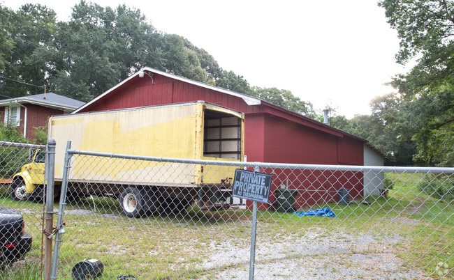
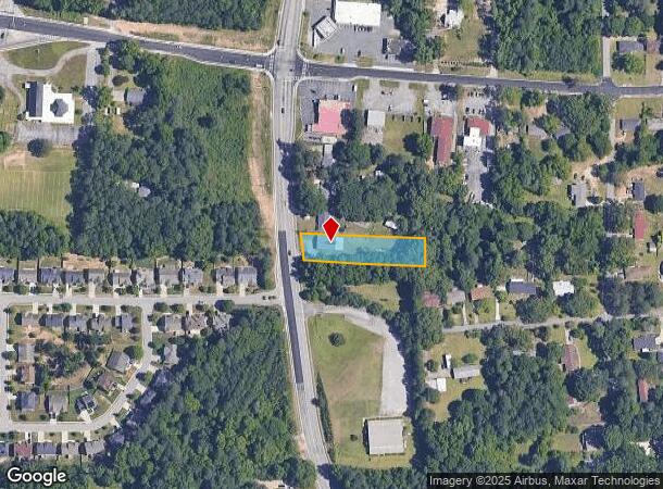
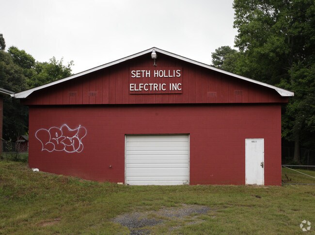
Property Record
6821 Factory Shoals Rd, Austell, GA 30168
NEARBY LISTINGS FOR SALE OR LEASE
Property Detail
6821 Factory Shoals Rd
Warehouse
Cobb
X
Georgia
13067C0212H
0.68 AC
2025
I-20 W/Douglasville
2025
Atlanta
031319
Atlanta-Sandy Springs-Roswell, GA
2,964 SF
18-0413-0-030-0
DEMOGRAPHICS near 6821 Factory Shoals Rd
1 Mile
3 Mile
5 Mile
2024 Total Population
10,030
50,908
125,638
2029 Population
10,231
51,977
128,840
Pop Growth 2024-2029
+ 2.00%
+ 2.10%
+ 2.55%
Average Age
35
36
38
2024 Total Households
3,589
18,844
48,185
HH Growth 2024-2029
+ 2.01%
+ 2.12%
+ 2.58%
Median Household Inc
$51,101
$60,042
$67,432
Avg Household Size
2.70
2.60
2.50
2024 Avg HH Vehicles
2.00
2.00
2.00
Median Home Value
$168,274
$220,878
$262,754
Median Year Built
1981
1986
1987
Nearby Places
Map Layers
Map Styles
 Street
 Aerial
- Restaurants
- Banks
- Shops
- Fitness
- Groceries
PUBLIC TRANSPORTATION
AIRPORT
Hartsfield - Jackson Atlanta International
DRIVE
WALK
Distance
Hartsfield - Jackson Atlanta International
32 min
20.5 mi
Nearby Properties
Address
Land Use
TOTAL SIZE
Lot Size
Zoning
Address
Land Use
TOTAL SIZE
Lot Size
Zoning
454,000 SF
68.17 AC
LI-R
Address
Land Use
TOTAL SIZE
Lot Size
Zoning
840,110 SF
53.36 AC
PUD
Address
Land Use
TOTAL SIZE
Lot Size
Zoning
789,717 SF
68.55 AC
LI
Address
Land Use
TOTAL SIZE
Lot Size
Zoning
417,860 SF
40.32 AC
LI
Address
Land Use
TOTAL SIZE
Lot Size
Zoning
913,620 SF
58.88 AC
Address
Land Use
TOTAL SIZE
Lot Size
Zoning
603,096 SF
38.38 AC
HI
Address
Land Use
TOTAL SIZE
Lot Size
Zoning
307,169 SF
30.13 AC
LI
Address
Land Use
TOTAL SIZE
Lot Size
Zoning
285,933 SF
46.22 AC
R-MF
Address
Land Use
TOTAL SIZE
Lot Size
Zoning
290,784 SF
21.09 AC
RM-12
Address
Land Use
TOTAL SIZE
Lot Size
Zoning
494,858 SF
43.29 AC
IL
Address
Land Use
TOTAL SIZE
Lot Size
Zoning
694,436 SF
36.80 AC
HI
Address
Land Use
TOTAL SIZE
Lot Size
Zoning
283,396 SF
29.88 AC
RM-12
Address
Land Use
TOTAL SIZE
Lot Size
Zoning
538,748 SF
35.64 AC
LI
Address
Land Use
TOTAL SIZE
Lot Size
Zoning
245,812 SF
30.90 AC
DCD
Address
Land Use
TOTAL SIZE
Lot Size
Zoning
523,551 SF
50.93 AC
LI
Address
Land Use
TOTAL SIZE
Lot Size
Zoning
490,726 SF
50.62 AC
LI-R
Address
Land Use
TOTAL SIZE
Lot Size
Zoning
567,480 SF
44.13 AC
LI
Address
Land Use
TOTAL SIZE
Lot Size
Zoning
70.12 AC
Address
Land Use
TOTAL SIZE
Lot Size
Zoning
241,200 SF
18.40 AC
RM-12
Address
Land Use
TOTAL SIZE
Lot Size
Zoning
240,612 SF
23.22 AC
R-6
Address
Land Use
TOTAL SIZE
Lot Size
Zoning
498,167 SF
11.18 AC
HI/WS
Address
Land Use
TOTAL SIZE
Lot Size
Zoning
428,974 SF
26.57 AC
LI-R
Address
Land Use
TOTAL SIZE
Lot Size
Zoning
351,845 SF
29.99 AC
LI-R
Address
Land Use
TOTAL SIZE
Lot Size
Zoning
311,073 SF
56.51 AC
LI
Address
Land Use
TOTAL SIZE
Lot Size
Zoning
152,348 SF
12.76 AC
RM-12
Address
Land Use
TOTAL SIZE
Lot Size
Zoning
350,840 SF
22.90 AC
LI
Address
Land Use
TOTAL SIZE
Lot Size
Zoning
380,000 SF
33.97 AC
IL
Address
Land Use
TOTAL SIZE
Lot Size
Zoning
151,436 SF
11.42 AC
RM-12
Address
Land Use
TOTAL SIZE
Lot Size
Zoning
353,269 SF
32.80 AC
LI
Address
Land Use
TOTAL SIZE
Lot Size
Zoning
343,360 SF
26.72 AC
LI
The World's #1 Commercial Real Estate Marketplace
Connect with us
© 2025 CoStar Group
The information above has been obtained from sources believed reliable. While we do not doubt its accuracy we have not verified it and make no guarantee, warranty or representation about it. It is your responsibility to independently confirm its accuracy and completeness. Any projections, opinions, assumptions, or estimates used are for example only and do not represent the current or future performance of the property. The value of this transaction to you depends on tax and other factors which should be evaluated by your tax, financial, and legal advisors. You and your advisors should conduct a careful, independent investigation of the property to determine to your satisfaction the suitability of the property for your needs.