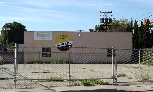
Property Record
6832 Foster Bridge Blvd, Bell Gardens, CA 90201
NEARBY LISTINGS FOR SALE OR LEASE
Property Detail
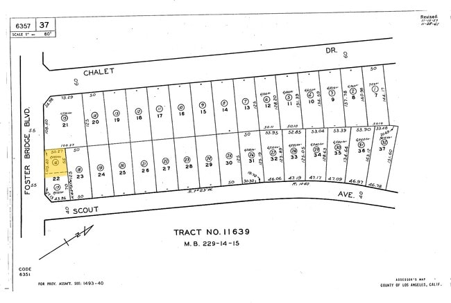
6832 Foster Bridge Blvd
Los Angeles-Long Beach-Glendale, CA
Rancho San Antonio
6358-015-057
SAN ANTONIO RANCHO POR OF SD RO N
Lightindustrial
Los Angeles
X
California
06037C1810F
1
2024
1.28 AC
2025
Mid-Cities
534002
Los Angeles
19,400 SF
DEMOGRAPHICS near 6832 Foster Bridge Blvd
1 Mile
3 Mile
5 Mile
2024 Total Population
25,473
210,284
679,018
2029 Population
24,222
200,734
647,526
Pop Growth 2024-2029
(4.91%)
(4.54%)
(4.64%)
Average Age
38
38
38
2024 Total Households
6,907
59,008
186,356
HH Growth 2024-2029
(5.10%)
(4.70%)
(4.88%)
Median Household Inc
$69,308
$67,331
$68,040
Avg Household Size
3.60
3.50
3.50
2024 Avg HH Vehicles
2.00
2.00
2.00
Median Home Value
$688,714
$671,988
$638,823
Median Year Built
1957
1958
1956
Nearby Places
- Restaurants
- Banks
- Shops
- Fitness
- Groceries
PUBLIC TRANSPORTATION
COMMUTER RAIL
Commerce (91 Line - Southern California Regional Rail Authority (Metrolink), Orange County Line - Southern California Regional Rail Authority (Metrolink))
DRIVE
WALK
Distance
Commerce (91 Line - Southern California Regional Rail Authority (Metrolink), Orange County Line - Southern California Regional Rail Authority (Metrolink))
6 min
2.4 mi
Montebello/Commerce (Riverside Line - Southern California Regional Rail Authority (Metrolink))
DRIVE
WALK
Distance
Montebello/Commerce (Riverside Line - Southern California Regional Rail Authority (Metrolink))
8 min
3.8 mi
AIRPORT
Long Beach (Daugherty Field)
DRIVE
WALK
Distance
Long Beach (Daugherty Field)
24 min
14.7 mi
Los Angeles International
DRIVE
WALK
Distance
Los Angeles International
29 min
20.7 mi
Bob Hope
DRIVE
WALK
Distance
Bob Hope
36 min
25.8 mi
Freight Ports
Port of Long Beach
DRIVE
WALK
Distance
Port of Long Beach
25 min
17.5 mi
Nearby Properties
Address
Land Use
TOTAL SIZE
Lot Size
Zoning
Address
Land Use
TOTAL SIZE
Lot Size
Zoning
271,020 SF
18.93 AC
CMM2*
Address
Land Use
TOTAL SIZE
Lot Size
Zoning
693,282 SF
30.34 AC
CMM2*
Address
Land Use
TOTAL SIZE
Lot Size
Zoning
397,549 SF
15.73 AC
CMM2*
Address
Land Use
TOTAL SIZE
Lot Size
Zoning
368,164 SF
7.82 AC
CMM2YY
Address
Land Use
TOTAL SIZE
Lot Size
Zoning
557,445 SF
14.08 AC
CMM2YY
Address
Land Use
TOTAL SIZE
Lot Size
Zoning
51,000 SF
27.18 AC
SGM3
Address
Land Use
TOTAL SIZE
Lot Size
Zoning
267,736 SF
9.04 AC
BGC4*
Address
Land Use
TOTAL SIZE
Lot Size
Zoning
609,466 SF
19.83 AC
CMM2*
Address
Land Use
TOTAL SIZE
Lot Size
Zoning
332,504 SF
7.76 AC
DOHM
Address
Land Use
TOTAL SIZE
Lot Size
Zoning
621,121 SF
13.07 AC
CMM2*
Address
Land Use
TOTAL SIZE
Lot Size
Zoning
244,768 SF
10.59 AC
PR1G
Address
Land Use
TOTAL SIZE
Lot Size
Zoning
875,558 SF
24.08 AC
CMM2*
Address
Land Use
TOTAL SIZE
Lot Size
Zoning
841,076 SF
23.77 AC
CMM2*
Address
Land Use
TOTAL SIZE
Lot Size
Zoning
170,222 SF
7.50 AC
PR1G
Address
Land Use
TOTAL SIZE
Lot Size
Zoning
117,004 SF
6.27 AC
CMM2*
Address
Land Use
TOTAL SIZE
Lot Size
Zoning
168,548 SF
7.53 AC
CMM2*
Address
Land Use
TOTAL SIZE
Lot Size
Zoning
188,940 SF
9 AC
PR1G
Address
Land Use
TOTAL SIZE
Lot Size
Zoning
513,222 SF
13.35 AC
PR1G
Address
Land Use
TOTAL SIZE
Lot Size
Zoning
43,406 SF
5.67 AC
SGM2
Address
Land Use
TOTAL SIZE
Lot Size
Zoning
382,648 SF
14.73 AC
CMM2*
Address
Land Use
TOTAL SIZE
Lot Size
Zoning
175,443 SF
7.18 AC
BLCM*
Address
Land Use
TOTAL SIZE
Lot Size
Zoning
1,094,138 SF
23.73 AC
CMM2YY
Address
Land Use
TOTAL SIZE
Lot Size
Zoning
105,586 SF
9.96 AC
SGM3*
Address
Land Use
TOTAL SIZE
Lot Size
Zoning
118,026 SF
5.73 AC
CMM2*
Address
Land Use
TOTAL SIZE
Lot Size
Zoning
298,629 SF
6.93 AC
BGMPD*
Address
Land Use
TOTAL SIZE
Lot Size
Zoning
244,390 SF
12.99 AC
CMM2
Address
Land Use
TOTAL SIZE
Lot Size
Zoning
826,068 SF
21.11 AC
Address
Land Use
TOTAL SIZE
Lot Size
Zoning
289,422 SF
12.43 AC
CMM2*
Address
Land Use
TOTAL SIZE
Lot Size
Zoning
483,890 SF
12.45 AC
BLM*
Address
Land Use
TOTAL SIZE
Lot Size
Zoning
378,720 SF
13.08 AC
SGM3*
The World's #1 Commercial Real Estate Marketplace
Connect with us
© 2025 CoStar Group
The information above has been obtained from sources believed reliable. While we do not doubt its accuracy we have not verified it and make no guarantee, warranty or representation about it. It is your responsibility to independently confirm its accuracy and completeness. Any projections, opinions, assumptions, or estimates used are for example only and do not represent the current or future performance of the property. The value of this transaction to you depends on tax and other factors which should be evaluated by your tax, financial, and legal advisors. You and your advisors should conduct a careful, independent investigation of the property to determine to your satisfaction the suitability of the property for your needs.