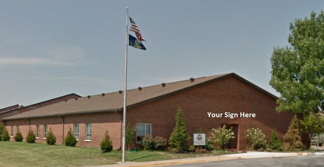
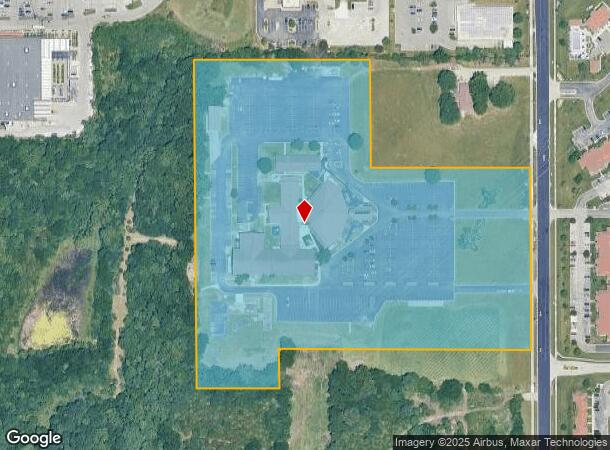
Property Record
6824 Lackman Rd, Shawnee, KS 66217
NEARBY LISTINGS FOR SALE OR LEASE
Property Detail
6824 Lackman Rd
QF241217-4003
17-12-24 BG 330' S NW CR NE1/4SE1/4 E 792' X S 330' EX W 261.80' & S1/2 NE1/4 SE1/4 EX E 40' & EX W 261.80' & EX S 120' W 810' E 850' 17.213 ACS M/L SHC 591 BTAO 4497 80 TG
Religious
Johnson
X
Kansas
20209C0145E
17.67 AC
2024
Northwest Johnson County
2024
Kansas City
052307
Kansas City, MO-KS
42,603 SF
DEMOGRAPHICS near 6824 Lackman Rd
1 mile
3 mile
5 mile
2024 Total Population
6,685
64,941
154,117
2029 Population
6,899
67,402
159,512
Pop Growth 2024-2029
+ 3.20%
+ 3.79%
+ 3.50%
Average Age
41
41
40
2024 Total Households
2,817
27,699
63,643
HH Growth 2024-2029
+ 3.34%
+ 3.90%
+ 3.68%
Median Household Inc
$88,247
$82,158
$82,379
Avg Household Size
2.30
2.30
2.40
2024 Avg HH Vehicles
2.00
2.00
2.00
Median Home Value
$309,233
$298,099
$275,539
Median Year Built
1989
1983
1979
Nearby Places
Map Layers
Map Styles
 Street
 Aerial
Transit
 Traffic
 Biking
Places
Listings with unknown addresses are not visible on the map
- Restaurants
- Banks
- Shops
- Fitness
- Groceries
PUBLIC TRANSPORTATION
AIRPORT
Kansas City International
Drive
Walk
Distance
Kansas City International
39 min
31.8 mi
Freight Ports
Tulsa Port Of Catoosa
Drive
Walk
Distance
Tulsa Port Of Catoosa
261 min
230.6 mi
SALE & LEASE HISTORY
LISTING DATE
SALE/LEASE

Jun 29, 2020
For Lease
Nearby Properties
Address
Land Use
TOTAL SIZE
Lot Size
Zoning
Address
Land Use
TOTAL SIZE
Lot Size
Zoning
279,588 SF
19.50 AC
RP5
Address
Land Use
TOTAL SIZE
Lot Size
Zoning
203,079 SF
8.10 AC
BP2
Address
Land Use
TOTAL SIZE
Lot Size
Zoning
133,932 SF
3.29 AC
CC
Address
Land Use
TOTAL SIZE
Lot Size
Zoning
202,842 SF
10.20 AC
PD
Address
Land Use
TOTAL SIZE
Lot Size
Zoning
83,537 SF
27.65 AC
AG
Address
Land Use
TOTAL SIZE
Lot Size
Zoning
69,872 SF
1.91 AC
CC
Address
Land Use
TOTAL SIZE
Lot Size
Zoning
120,492 SF
10 AC
R1
Address
Land Use
TOTAL SIZE
Lot Size
Zoning
141,340 SF
19.92 AC
R1
Address
Land Use
TOTAL SIZE
Lot Size
Zoning
89,477 SF
16.45 AC
R-1
Address
Land Use
TOTAL SIZE
Lot Size
Zoning
75,010 SF
24.78 AC
RP2
Address
Land Use
TOTAL SIZE
Lot Size
Zoning
75,010 SF
5.53 AC
PD
Address
Land Use
TOTAL SIZE
Lot Size
Zoning
72,994 SF
7.99 AC
RP3
Address
Land Use
TOTAL SIZE
Lot Size
Zoning
49,282 SF
11.89 AC
RP1
Address
Land Use
TOTAL SIZE
Lot Size
Zoning
85,940 SF
9.08 AC
RGA
Address
Land Use
TOTAL SIZE
Lot Size
Zoning
139,880 SF
17.18 AC
R1
Address
Land Use
TOTAL SIZE
Lot Size
Zoning
36,903 SF
0.55 AC
CC
Address
Land Use
TOTAL SIZE
Lot Size
Zoning
88,866 SF
21.54 AC
RS
Address
Land Use
TOTAL SIZE
Lot Size
Zoning
81,361 SF
3.81 AC
AG
Address
Land Use
TOTAL SIZE
Lot Size
Zoning
70,952 SF
9.98 AC
R-1
Address
Land Use
TOTAL SIZE
Lot Size
Zoning
85,469 SF
10.32 AC
CPO
Address
Land Use
TOTAL SIZE
Lot Size
Zoning
56,347 SF
0.76 AC
CC
Address
Land Use
TOTAL SIZE
Lot Size
Zoning
77,758 SF
4.89 AC
R-1
Address
Land Use
TOTAL SIZE
Lot Size
Zoning
35,848 SF
74.74 AC
R1
Address
Land Use
TOTAL SIZE
Lot Size
Zoning
34,641 SF
14.33 AC
AG
Address
Land Use
TOTAL SIZE
Lot Size
Zoning
66,314 SF
8.47 AC
R1
Address
Land Use
TOTAL SIZE
Lot Size
Zoning
186,546 SF
20.42 AC
CP2
Address
Land Use
TOTAL SIZE
Lot Size
Zoning
83,915 SF
12.61 AC
R1
Address
Land Use
TOTAL SIZE
Lot Size
Zoning
297,730 SF
15.75 AC
CN
Address
Land Use
TOTAL SIZE
Lot Size
Zoning
83,186 SF
28.33 AC
RP-4
The World's #1 Commercial Real Estate Marketplace
Connect with us
© 2026 CoStar Group
The information above has been obtained from sources believed reliable. While we do not doubt its accuracy we have not verified it and make no guarantee, warranty or representation about it. It is your responsibility to independently confirm its accuracy and completeness. Any projections, opinions, assumptions, or estimates used are for example only and do not represent the current or future performance of the property. The value of this transaction to you depends on tax and other factors which should be evaluated by your tax, financial, and legal advisors. You and your advisors should conduct a careful, independent investigation of the property to determine to your satisfaction the suitability of the property for your needs.