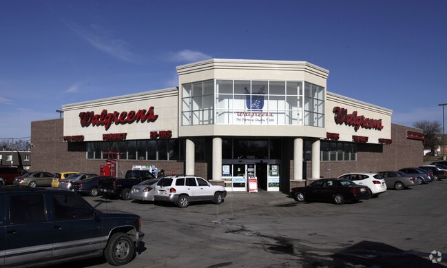
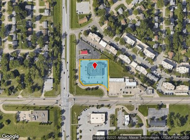
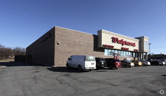
Property Record
6827 S 84Th St, Omaha, NE 68127

NEARBY LISTINGS FOR SALE OR LEASE
Property Detail
6827 S 84Th St
Omaha-Council Bluffs, NE-IA
Wildewood
3772-1000-25
WILDEWOOD REP 1* LOT 1 BLOCK 0 IRREG 1.49 AC
Storebuilding
Douglas
X
Nebraska
31153C0060G
1
2024
1.50 AC
2025
South Central Omaha
007467
Omaha/Council Bluffs
14,790 SF
DEMOGRAPHICS near 6827 S 84Th St
1 Mile
3 Mile
5 Mile
2024 Total Population
15,861
83,004
209,056
2029 Population
16,763
86,519
216,613
Pop Growth 2024-2029
+ 5.69%
+ 4.23%
+ 3.61%
Average Age
39
39
38
2024 Total Households
6,822
34,202
83,577
HH Growth 2024-2029
+ 5.72%
+ 4.11%
+ 3.60%
Median Household Inc
$56,105
$68,696
$71,259
Avg Household Size
2.30
2.40
2.40
2024 Avg HH Vehicles
2.00
2.00
2.00
Median Home Value
$186,315
$220,689
$220,428
Median Year Built
1977
1980
1975
Nearby Places
Map Layers
Map Styles
 Street
 Aerial
- Restaurants
- Banks
- Shops
- Fitness
- Groceries
PUBLIC TRANSPORTATION
COMMUTER RAIL
DRIVE
WALK
Distance
16 min
9.6 mi
DRIVE
WALK
Distance
16 min
9.8 mi
AIRPORT
Eppley Airfield
DRIVE
WALK
Distance
Eppley Airfield
24 min
13.7 mi
Nearby Properties
Address
Land Use
TOTAL SIZE
Lot Size
Zoning
Address
Land Use
TOTAL SIZE
Lot Size
Zoning
25,204 SF
2.34 AC
R4
Address
Land Use
TOTAL SIZE
Lot Size
Zoning
28,820 SF
16.81 AC
Address
Land Use
TOTAL SIZE
Lot Size
Zoning
341,667 SF
24.15 AC
Address
Land Use
TOTAL SIZE
Lot Size
Zoning
503,886 SF
25.40 AC
Address
Land Use
TOTAL SIZE
Lot Size
Zoning
599,779 SF
46.87 AC
I1
Address
Land Use
TOTAL SIZE
Lot Size
Zoning
317,277 SF
20.12 AC
Address
Land Use
TOTAL SIZE
Lot Size
Zoning
28,913 SF
2.04 AC
Address
Land Use
TOTAL SIZE
Lot Size
Zoning
897,738 SF
52.16 AC
Address
Land Use
TOTAL SIZE
Lot Size
Zoning
23,890 SF
14.34 AC
I2
Address
Land Use
TOTAL SIZE
Lot Size
Zoning
354,299 SF
22.85 AC
R6
Address
Land Use
TOTAL SIZE
Lot Size
Zoning
294,672 SF
15.06 AC
Address
Land Use
TOTAL SIZE
Lot Size
Zoning
646,213 SF
37.22 AC
Address
Land Use
TOTAL SIZE
Lot Size
Zoning
13,930 SF
1.04 AC
Address
Land Use
TOTAL SIZE
Lot Size
Zoning
199,152 SF
13.44 AC
R6
Address
Land Use
TOTAL SIZE
Lot Size
Zoning
271,344 SF
9.78 AC
Address
Land Use
TOTAL SIZE
Lot Size
Zoning
271,404 SF
17.51 AC
Address
Land Use
TOTAL SIZE
Lot Size
Zoning
309,162 SF
15.54 AC
Address
Land Use
TOTAL SIZE
Lot Size
Zoning
258,637 SF
24.30 AC
Address
Land Use
TOTAL SIZE
Lot Size
Zoning
97,617 SF
49.05 AC
Address
Land Use
TOTAL SIZE
Lot Size
Zoning
2,610 SF
9.96 AC
Address
Land Use
TOTAL SIZE
Lot Size
Zoning
286,445 SF
16.18 AC
R6
Address
Land Use
TOTAL SIZE
Lot Size
Zoning
407,410 SF
4.03 AC
Address
Land Use
TOTAL SIZE
Lot Size
Zoning
12,998 SF
15.63 AC
Address
Land Use
TOTAL SIZE
Lot Size
Zoning
237,171 SF
10.27 AC
R6
Address
Land Use
TOTAL SIZE
Lot Size
Zoning
225,009 SF
12.03 AC
Address
Land Use
TOTAL SIZE
Lot Size
Zoning
325,661 SF
9.32 AC
GI
Address
Land Use
TOTAL SIZE
Lot Size
Zoning
329,578 SF
14.30 AC
GI
Address
Land Use
TOTAL SIZE
Lot Size
Zoning
14,019 SF
10.92 AC
Address
Land Use
TOTAL SIZE
Lot Size
Zoning
199,586 SF
2.93 AC
Address
Land Use
TOTAL SIZE
Lot Size
Zoning
88,422 SF
12.10 AC
The World's #1 Commercial Real Estate Marketplace
Connect with us
© 2025 CoStar Group
The information above has been obtained from sources believed reliable. While we do not doubt its accuracy we have not verified it and make no guarantee, warranty or representation about it. It is your responsibility to independently confirm its accuracy and completeness. Any projections, opinions, assumptions, or estimates used are for example only and do not represent the current or future performance of the property. The value of this transaction to you depends on tax and other factors which should be evaluated by your tax, financial, and legal advisors. You and your advisors should conduct a careful, independent investigation of the property to determine to your satisfaction the suitability of the property for your needs.