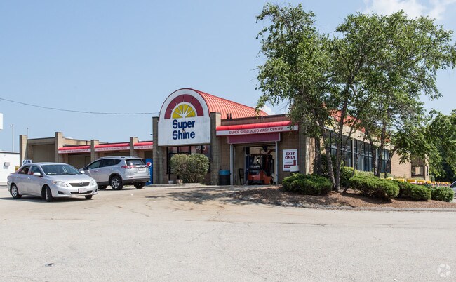
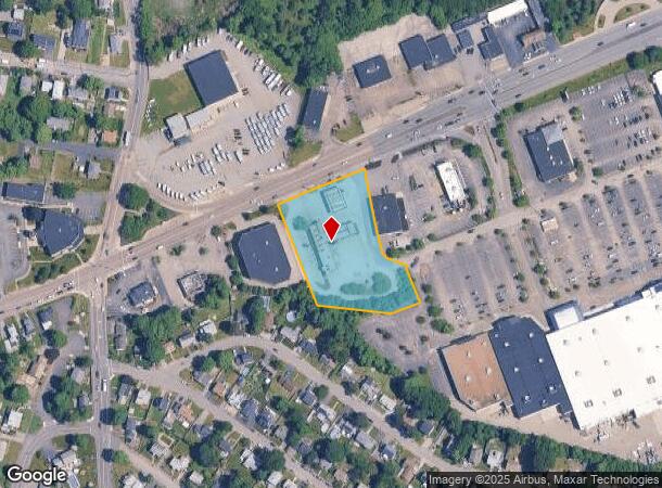
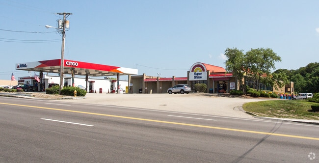
Property Record
683 Bridge St, North Weymouth, MA 02191
NEARBY LISTINGS FOR SALE OR LEASE
Property Detail
683 Bridge St
WEYM-000008-000015-000006
Norfolk
Commercialnec
Massachusetts
X
6
25021C0227G
1.91 AC
2024
Route 3 Corridor
2025
Boston
422700
Boston-Cambridge-Newton, MA-NH
DEMOGRAPHICS near 683 Bridge St
1 Mile
3 Mile
5 Mile
2024 Total Population
8,675
77,837
191,123
2029 Population
8,700
77,614
190,652
Pop Growth 2024-2029
+ 0.29%
(0.29%)
(0.25%)
Average Age
44
43
42
2024 Total Households
3,658
32,970
80,430
HH Growth 2024-2029
+ 0.55%
(0.29%)
(0.19%)
Median Household Inc
$105,330
$93,191
$98,101
Avg Household Size
2.30
2.30
2.30
2024 Avg HH Vehicles
2.00
2.00
2.00
Median Home Value
$470,479
$526,021
$597,136
Median Year Built
1954
1959
1959
Nearby Places
Map Layers
Map Styles
 Street
 Aerial
- Restaurants
- Banks
- Shops
- Fitness
- Groceries
PUBLIC TRANSPORTATION
COMMUTER RAIL
West Hingham (Greenbush Line - Massachusetts Bay Transportation Authority Commuter Rail (Purple Line))
DRIVE
WALK
Distance
West Hingham (Greenbush Line - Massachusetts Bay Transportation Authority Commuter Rail (Purple Line))
5 min
2.3 mi
East Weymouth (Greenbush Line - Massachusetts Bay Transportation Authority Commuter Rail (Purple Line))
DRIVE
WALK
Distance
East Weymouth (Greenbush Line - Massachusetts Bay Transportation Authority Commuter Rail (Purple Line))
7 min
3.3 mi
AIRPORT
General Edward Lawrence Logan International
DRIVE
WALK
Distance
General Edward Lawrence Logan International
28 min
14.7 mi
Freight Ports
Port of Boston
DRIVE
WALK
Distance
Port of Boston
25 min
12.5 mi
Nearby Properties
Address
Land Use
TOTAL SIZE
Lot Size
Zoning
Address
Land Use
TOTAL SIZE
Lot Size
Zoning
33.81 AC
A3
Address
Land Use
TOTAL SIZE
Lot Size
Zoning
9.10 AC
RESC
Address
Land Use
TOTAL SIZE
Lot Size
Zoning
233,488 SF
9.82 AC
Address
Land Use
TOTAL SIZE
Lot Size
Zoning
11.90 AC
PUD
Address
Land Use
TOTAL SIZE
Lot Size
Zoning
229,928 SF
3.79 AC
Address
Land Use
TOTAL SIZE
Lot Size
Zoning
233,530 SF
6.70 AC
PUD
Address
Land Use
TOTAL SIZE
Lot Size
Zoning
172,027 SF
3.73 AC
100
Address
Land Use
TOTAL SIZE
Lot Size
Zoning
617,116 SF
79.59 AC
INDB
Address
Land Use
TOTAL SIZE
Lot Size
Zoning
204,944 SF
3.83 AC
Address
Land Use
TOTAL SIZE
Lot Size
Zoning
9.94 AC
Address
Land Use
TOTAL SIZE
Lot Size
Zoning
3,375 SF
12.03 AC
PUD
Address
Land Use
TOTAL SIZE
Lot Size
Zoning
10.04 AC
PUD
Address
Land Use
TOTAL SIZE
Lot Size
Zoning
11.39 AC
100
Address
Land Use
TOTAL SIZE
Lot Size
Zoning
111,871 SF
4.72 AC
RESC
Address
Land Use
TOTAL SIZE
Lot Size
Zoning
5.03 AC
Address
Land Use
TOTAL SIZE
Lot Size
Zoning
5.59 AC
PUD
Address
Land Use
TOTAL SIZE
Lot Size
Zoning
132,194 SF
4 AC
RESC
Address
Land Use
TOTAL SIZE
Lot Size
Zoning
231,358 SF
40.22 AC
Address
Land Use
TOTAL SIZE
Lot Size
Zoning
123,968 SF
4.93 AC
BUSB
Address
Land Use
TOTAL SIZE
Lot Size
Zoning
159,106 SF
3.41 AC
PUD
Address
Land Use
TOTAL SIZE
Lot Size
Zoning
79,687 SF
3.52 AC
75
Address
Land Use
TOTAL SIZE
Lot Size
Zoning
2.56 AC
100
Address
Land Use
TOTAL SIZE
Lot Size
Zoning
107,410 SF
1.22 AC
85
Address
Land Use
TOTAL SIZE
Lot Size
Zoning
91,586 SF
1.41 AC
RESB
Address
Land Use
TOTAL SIZE
Lot Size
Zoning
73,614 SF
9.81 AC
PUD
Address
Land Use
TOTAL SIZE
Lot Size
Zoning
10.08 AC
PUD
Address
Land Use
TOTAL SIZE
Lot Size
Zoning
8.96 AC
Address
Land Use
TOTAL SIZE
Lot Size
Zoning
11.43 AC
Address
Land Use
TOTAL SIZE
Lot Size
Zoning
124,270 SF
17.25 AC
PUD
Address
Land Use
TOTAL SIZE
Lot Size
Zoning
2.81 AC
A3
The World's #1 Commercial Real Estate Marketplace
Connect with us
© 2025 CoStar Group
The information above has been obtained from sources believed reliable. While we do not doubt its accuracy we have not verified it and make no guarantee, warranty or representation about it. It is your responsibility to independently confirm its accuracy and completeness. Any projections, opinions, assumptions, or estimates used are for example only and do not represent the current or future performance of the property. The value of this transaction to you depends on tax and other factors which should be evaluated by your tax, financial, and legal advisors. You and your advisors should conduct a careful, independent investigation of the property to determine to your satisfaction the suitability of the property for your needs.