Property Record
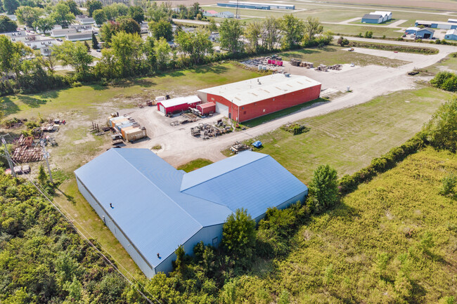
683 S River Rd, Bay City, MI 48708

This Property Is For Sale
Property Detail
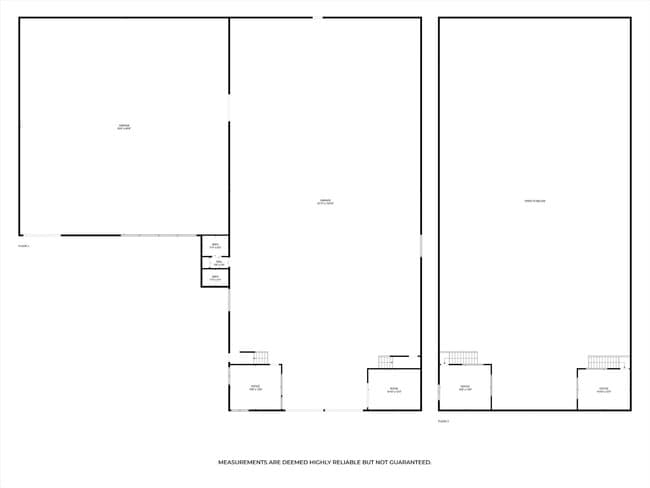
683 S River Rd
09-130-009-100-030-01
COM AT N 1/4 COR OF SEC TH W 646 FT TH S 14D 52M E 1699.2 FT TH S 84D 26M W 50.67 FT TO POB TH S 84D 26M W 834.8 FT TH N 22D 36M W 150 FT ALG HWY TH N 84D 07M E 854.51 FT TH S 14D 52M E 150 FT TO BEG SEC 9 T13N R5E D#1 11-3-77
Manufacturinglight
BAY
AE The base floodplain where base flood elevations are provided. AE Zones are now used on new format FIRMs instead of A1-A30 Zones.
Michigan
2025
2.91 AC
2025
Midland/Flint
280600
Other Market Areas
11,552 SF
Bay City, MI
NEARBY LISTINGS FOR SALE OR LEASE
DEMOGRAPHICS near 683 S River Rd
1 mile
3 mile
5 mile
2025 Total Population
1,079
18,047
54,325
2030 Population
1,092
17,897
53,983
Pop Growth 2025-2030
+ 1.20%
(0.83%)
(0.63%)
Average Age
45
43
43
2025 Total Households
497
7,804
24,217
HH Growth 2025-2030
+ 1.41%
(0.91%)
(0.61%)
Median Household Inc
$66,760
$51,652
$53,177
Avg Household Size
2.10
2.20
2.20
2025 Avg HH Vehicles
2.00
2.00
2.00
Median Home Value
$142,513
$120,685
$134,672
Median Year Built
1964
1950
1953
Nearby Places
Map Layers
Map Styles
 Street
 Aerial
Layers
 Traffic
 Biking
Places
Listings with unknown addresses are not visible on the map
- Restaurants
- Banks
- Shops
- Fitness
- Groceries
PUBLIC TRANSPORTATION
AIRPORT
MBS International
Drive
Walk
Distance
MBS International
28 min
18.1 mi
Freight Ports
Port of Toledo
Drive
Walk
Distance
Port of Toledo
177 min
152.6 mi
Nearby Properties
Address
Land Use
TOTAL SIZE
Lot Size
Zoning
Address
Land Use
TOTAL SIZE
Lot Size
Zoning
279,395 SF
192 AC
I-2
Address
Land Use
TOTAL SIZE
Lot Size
Zoning
60,200 SF
9.50 AC
C-3 CTRL B
Address
Land Use
TOTAL SIZE
Lot Size
Zoning
1.87 AC
C-3 CTRL B
Address
Land Use
TOTAL SIZE
Lot Size
Zoning
15.15 AC
M-1 LT IND
Address
Land Use
TOTAL SIZE
Lot Size
Zoning
22,356 SF
I-2
Address
Land Use
TOTAL SIZE
Lot Size
Zoning
M-1 LT IND
Address
Land Use
TOTAL SIZE
Lot Size
Zoning
1.91 AC
Address
Land Use
TOTAL SIZE
Lot Size
Zoning
3,087 SF
21.78 AC
RMH RES MO
Address
Land Use
TOTAL SIZE
Lot Size
Zoning
162,182 SF
4.76 AC
Address
Land Use
TOTAL SIZE
Lot Size
Zoning
47,100 SF
7.54 AC
C-2B HWY B
Address
Land Use
TOTAL SIZE
Lot Size
Zoning
161,292 SF
11.16 AC
M-1 LT IND
Address
Land Use
TOTAL SIZE
Lot Size
Zoning
1.47 AC
Address
Land Use
TOTAL SIZE
Lot Size
Zoning
225,840 SF
17.02 AC
WF WATERFR
Address
Land Use
TOTAL SIZE
Lot Size
Zoning
80,030 SF
3.47 AC
M-2 GEN IN
Address
Land Use
TOTAL SIZE
Lot Size
Zoning
26,400 SF
1.98 AC
MUNICIPAL
Address
Land Use
TOTAL SIZE
Lot Size
Zoning
89,904 SF
12.61 AC
M-2 GEN IN
Address
Land Use
TOTAL SIZE
Lot Size
Zoning
10.67 AC
M-2 GEN IN
Address
Land Use
TOTAL SIZE
Lot Size
Zoning
107,957 SF
7.90 AC
M-1 LT IND
Address
Land Use
TOTAL SIZE
Lot Size
Zoning
20,960 SF
0.66 AC
C-3 CTRL B
Address
Land Use
TOTAL SIZE
Lot Size
Zoning
2.89 AC
Address
Land Use
TOTAL SIZE
Lot Size
Zoning
18,776 SF
1.32 AC
C-3 CTRL B
Address
Land Use
TOTAL SIZE
Lot Size
Zoning
4,218 SF
0.64 AC
C-2A GENL
Address
Land Use
TOTAL SIZE
Lot Size
Zoning
1,006 SF
9.57 AC
M-1 LT IND
Address
Land Use
TOTAL SIZE
Lot Size
Zoning
1.61 AC
Address
Land Use
TOTAL SIZE
Lot Size
Zoning
300 AC
A-1 AG
Address
Land Use
TOTAL SIZE
Lot Size
Zoning
452.63 AC
Address
Land Use
TOTAL SIZE
Lot Size
Zoning
7,450 SF
I-2
Address
Land Use
TOTAL SIZE
Lot Size
Zoning
2.87 AC
Address
Land Use
TOTAL SIZE
Lot Size
Zoning
11,060 SF
1.52 AC
C-2A GENL
Address
Land Use
TOTAL SIZE
Lot Size
Zoning
54,155 SF
4.58 AC
M-1 LT IND
The World's #1 Commercial Real Estate Marketplace
Connect with us
© 2026 CoStar Group
The information above has been obtained from sources believed reliable. While we do not doubt its accuracy we have not verified it and make no guarantee, warranty or representation about it. It is your responsibility to independently confirm its accuracy and completeness. Any projections, opinions, assumptions, or estimates used are for example only and do not represent the current or future performance of the property. The value of this transaction to you depends on tax and other factors which should be evaluated by your tax, financial, and legal advisors. You and your advisors should conduct a careful, independent investigation of the property to determine to your satisfaction the suitability of the property for your needs.