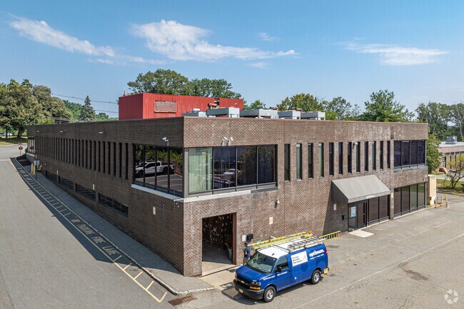
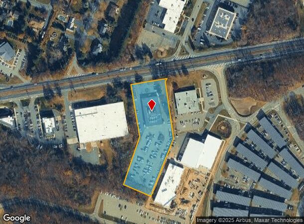
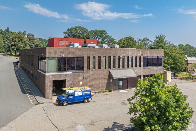
Property Record
683 State Route 10, Randolph, NJ 07869
NEARBY LISTINGS FOR SALE OR LEASE
Property Detail
683 State Route 10
Newark, NJ-PA
ADDITIONAL LOTS: B60 L17-A
32-00081-0000-00005
Morris
Commercialnec
New Jersey
2024
5
2025
3.09 AC
046500
Western Morris
38,420 SF
Northern New Jersey
DEMOGRAPHICS near 683 State Route 10
1 Mile
3 Mile
5 Mile
2024 Total Population
4,853
54,000
114,416
2029 Population
4,716
53,744
114,188
Pop Growth 2024-2029
(2.82%)
(0.47%)
(0.20%)
Average Age
41
40
42
2024 Total Households
1,937
18,295
41,202
HH Growth 2024-2029
(3.30%)
(0.56%)
(0.19%)
Median Household Inc
$97,706
$94,521
$113,577
Avg Household Size
2.40
2.90
2.70
2024 Avg HH Vehicles
2.00
2.00
2.00
Median Home Value
$535,714
$406,923
$442,340
Median Year Built
1977
1969
1973
Nearby Places
Map Layers
Map Styles
 Street
 Aerial
- Restaurants
- Banks
- Shops
- Fitness
- Groceries
PUBLIC TRANSPORTATION
COMMUTER RAIL
Dover (Montclair-Boonton Line - NJ Transit Commuter Rail (NJ Transit), Morris & Essex Morristown Line - NJ Transit Commuter Rail (NJ Transit))
DRIVE
WALK
Distance
Dover (Montclair-Boonton Line - NJ Transit Commuter Rail (NJ Transit), Morris & Essex Morristown Line - NJ Transit Commuter Rail (NJ Transit))
5 min
2.9 mi
Mount Tabor (Morris & Essex Morristown Line - NJ Transit Commuter Rail (NJ Transit))
DRIVE
WALK
Distance
Mount Tabor (Morris & Essex Morristown Line - NJ Transit Commuter Rail (NJ Transit))
12 min
6.6 mi
AIRPORT
Newark Liberty International
DRIVE
WALK
Distance
Newark Liberty International
39 min
30.9 mi
Freight Ports
Maher Terminal
DRIVE
WALK
Distance
Maher Terminal
43 min
31.5 mi
Nearby Properties
Address
Land Use
TOTAL SIZE
Lot Size
Zoning
Address
Land Use
TOTAL SIZE
Lot Size
Zoning
222.79 AC
R1
Address
Land Use
TOTAL SIZE
Lot Size
Zoning
64.62 AC
R3
Address
Land Use
TOTAL SIZE
Lot Size
Zoning
30.13 AC
I-3
Address
Land Use
TOTAL SIZE
Lot Size
Zoning
28.62 AC
OSGU
Address
Land Use
TOTAL SIZE
Lot Size
Zoning
197,412 SF
28.60 AC
OSGU
Address
Land Use
TOTAL SIZE
Lot Size
Zoning
23.66 AC
I1
Address
Land Use
TOTAL SIZE
Lot Size
Zoning
20.05 AC
R-1
Address
Land Use
TOTAL SIZE
Lot Size
Zoning
Address
Land Use
TOTAL SIZE
Lot Size
Zoning
276,378 SF
40.50 AC
OSGU
Address
Land Use
TOTAL SIZE
Lot Size
Zoning
195,773 SF
43.54 AC
R-4
Address
Land Use
TOTAL SIZE
Lot Size
Zoning
Address
Land Use
TOTAL SIZE
Lot Size
Zoning
19.47 AC
R-4
Address
Land Use
TOTAL SIZE
Lot Size
Zoning
13.53 AC
R10
Address
Land Use
TOTAL SIZE
Lot Size
Zoning
457,072 SF
64.13 AC
I-1
Address
Land Use
TOTAL SIZE
Lot Size
Zoning
199,694 SF
29.23 AC
B-3
Address
Land Use
TOTAL SIZE
Lot Size
Zoning
16.21 AC
R-4
Address
Land Use
TOTAL SIZE
Lot Size
Zoning
42.43 AC
R-5
Address
Land Use
TOTAL SIZE
Lot Size
Zoning
79,962 SF
27.80 AC
GU
Address
Land Use
TOTAL SIZE
Lot Size
Zoning
22,289 SF
5 AC
R1
Address
Land Use
TOTAL SIZE
Lot Size
Zoning
9.81 AC
B2
Address
Land Use
TOTAL SIZE
Lot Size
Zoning
4,200 SF
34.12 AC
GU
Address
Land Use
TOTAL SIZE
Lot Size
Zoning
12.61 AC
R-4
Address
Land Use
TOTAL SIZE
Lot Size
Zoning
68,830 SF
22 AC
OSGU
Address
Land Use
TOTAL SIZE
Lot Size
Zoning
102,050 SF
7.95 AC
R-2
Address
Land Use
TOTAL SIZE
Lot Size
Zoning
7.79 AC
B-4
Address
Land Use
TOTAL SIZE
Lot Size
Zoning
3.50 AC
B-2
Address
Land Use
TOTAL SIZE
Lot Size
Zoning
20.16 AC
I-1
Address
Land Use
TOTAL SIZE
Lot Size
Zoning
64,687 SF
15.79 AC
R3
Address
Land Use
TOTAL SIZE
Lot Size
Zoning
38,526 SF
10 AC
R2
Address
Land Use
TOTAL SIZE
Lot Size
Zoning
The World's #1 Commercial Real Estate Marketplace
Connect with us
© 2025 CoStar Group
The information above has been obtained from sources believed reliable. While we do not doubt its accuracy we have not verified it and make no guarantee, warranty or representation about it. It is your responsibility to independently confirm its accuracy and completeness. Any projections, opinions, assumptions, or estimates used are for example only and do not represent the current or future performance of the property. The value of this transaction to you depends on tax and other factors which should be evaluated by your tax, financial, and legal advisors. You and your advisors should conduct a careful, independent investigation of the property to determine to your satisfaction the suitability of the property for your needs.