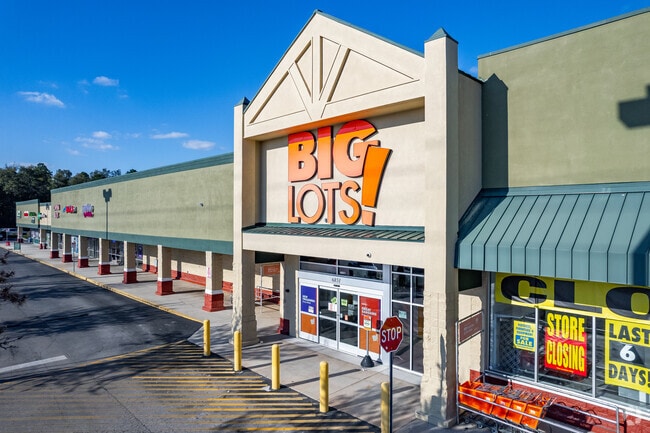
Property Record
6829 Se Maricamp Rd, Ocala, FL 34472
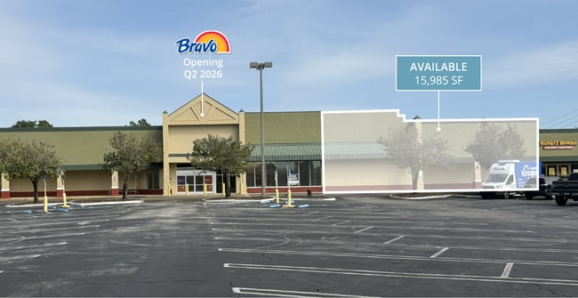
Current Lease Availabilities
NEARBY LISTINGS FOR SALE OR LEASE
Property Detail
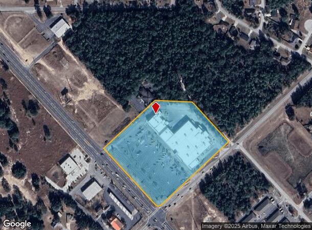
6829 Se Maricamp Rd
Ocala, FL
Silver Springs Shores
9019-0000-06
SEC 06 TWP 16 RGE 23 PLAT BOOK J PAGE 154 SILVER SPRINGS SHORES UNIT 19 TRACT TT A PORTION THEREOF DESCRIBED AS FOLLOWS: COM SLY COR OF TRACT TT SAID PT ALSO BEING INTERSECTION OF NELY ROW SR 464 & NWLY ROW OF PINE RD THENCE NWLY ALG NELY ROW OF SR 4
Regionalshoppingcenterormallwithanchorstore
Marion
X
Florida
12083C0545D
tt
2024
7.60 AC
2024
Outlying Marion County
001209
Ocala
71,418 SF
DEMOGRAPHICS near 6829 Se Maricamp Rd
1 Mile
3 Mile
5 Mile
2024 Total Population
7,550
40,985
74,890
2029 Population
8,627
46,866
85,118
Pop Growth 2024-2029
+ 14.26%
+ 14.35%
+ 13.66%
Average Age
37
40
41
2024 Total Households
2,622
15,537
28,927
HH Growth 2024-2029
+ 14.23%
+ 14.50%
+ 13.71%
Median Household Inc
$50,710
$56,496
$61,249
Avg Household Size
2.80
2.60
2.60
2024 Avg HH Vehicles
2.00
2.00
2.00
Median Home Value
$172,501
$164,067
$180,221
Median Year Built
2003
1995
1989
Nearby Places
- Restaurants
- Banks
- Shops
- Fitness
- Groceries
Nearby Properties
Address
Land Use
TOTAL SIZE
Lot Size
Zoning
Address
Land Use
TOTAL SIZE
Lot Size
Zoning
211,884 SF
80 AC
GU
Address
Land Use
TOTAL SIZE
Lot Size
Zoning
188,132 SF
35.86 AC
B4
Address
Land Use
TOTAL SIZE
Lot Size
Zoning
71,791 SF
10.86 AC
B2
Address
Land Use
TOTAL SIZE
Lot Size
Zoning
680,069 SF
62.96 AC
B5
Address
Land Use
TOTAL SIZE
Lot Size
Zoning
97,576 SF
23.01 AC
R3
Address
Land Use
TOTAL SIZE
Lot Size
Zoning
60,710 SF
66.65 AC
A1
Address
Land Use
TOTAL SIZE
Lot Size
Zoning
26,020 SF
10.46 AC
B2
Address
Land Use
TOTAL SIZE
Lot Size
Zoning
64,020 SF
10 AC
B5
Address
Land Use
TOTAL SIZE
Lot Size
Zoning
69,860 SF
5.05 AC
B2
Address
Land Use
TOTAL SIZE
Lot Size
Zoning
682 SF
468.13 AC
A1
Address
Land Use
TOTAL SIZE
Lot Size
Zoning
93,120 SF
34.47 AC
PUD
Address
Land Use
TOTAL SIZE
Lot Size
Zoning
68,186 SF
6.20 AC
B5
Address
Land Use
TOTAL SIZE
Lot Size
Zoning
98,428 SF
10 AC
M2
Address
Land Use
TOTAL SIZE
Lot Size
Zoning
64,319 SF
7.60 AC
B2
Address
Land Use
TOTAL SIZE
Lot Size
Zoning
61,220 SF
3.82 AC
B5
Address
Land Use
TOTAL SIZE
Lot Size
Zoning
20,040 SF
2.77 AC
B4
Address
Land Use
TOTAL SIZE
Lot Size
Zoning
23,865 SF
90.97 AC
GU
Address
Land Use
TOTAL SIZE
Lot Size
Zoning
34,277 SF
14.94 AC
B5
Address
Land Use
TOTAL SIZE
Lot Size
Zoning
22,812 SF
14.13 AC
M1
Address
Land Use
TOTAL SIZE
Lot Size
Zoning
55,219 SF
8.83 AC
B2
Address
Land Use
TOTAL SIZE
Lot Size
Zoning
27,964 SF
4.10 AC
R1
Address
Land Use
TOTAL SIZE
Lot Size
Zoning
20,242 SF
4.23 AC
B4
Address
Land Use
TOTAL SIZE
Lot Size
Zoning
9,687 SF
118.25 AC
B5
Address
Land Use
TOTAL SIZE
Lot Size
Zoning
8,782 SF
4.73 AC
B2
Address
Land Use
TOTAL SIZE
Lot Size
Zoning
37,765 SF
7.23 AC
B2
Address
Land Use
TOTAL SIZE
Lot Size
Zoning
10,044 SF
83.35 AC
A1
Address
Land Use
TOTAL SIZE
Lot Size
Zoning
6,069 SF
2.32 AC
B5
Address
Land Use
TOTAL SIZE
Lot Size
Zoning
17,595 SF
2.51 AC
B2
Address
Land Use
TOTAL SIZE
Lot Size
Zoning
16,742 SF
13.49 AC
A1
Address
Land Use
TOTAL SIZE
Lot Size
Zoning
198.70 AC
R3
The World's #1 Commercial Real Estate Marketplace
Connect with us
© 2025 CoStar Group
The information above has been obtained from sources believed reliable. While we do not doubt its accuracy we have not verified it and make no guarantee, warranty or representation about it. It is your responsibility to independently confirm its accuracy and completeness. Any projections, opinions, assumptions, or estimates used are for example only and do not represent the current or future performance of the property. The value of this transaction to you depends on tax and other factors which should be evaluated by your tax, financial, and legal advisors. You and your advisors should conduct a careful, independent investigation of the property to determine to your satisfaction the suitability of the property for your needs.