Property Record
6830 Sw Belvoir Dr, Arcadia, FL 34269
This Property Is For Sale
NEARBY LISTINGS FOR SALE OR LEASE
Property Detail
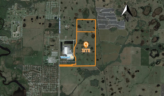
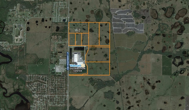
6830 Sw Belvoir Dr
Arcadia, FL
ALL LESS THAT PART OF NW1/4 OF NW1/4 MPDAF: BEG AT NE COR OF NW1/4 OF NW1/4 SEC 31 TH 89D45M03S W ALG N LI 585.70 FT TH S 04D53M18S W 79.48 FT TH N 85D43M13S W 527.65 FT TH S 00D 49M16S W 376.28 FT TH S 89D45M 03S E // WITH N LI SEC 31 1118.05 FT TH
30-39-24-0000-0010-0000
DeSoto
Pasture
Florida
2024
66.21 AC
2024
Florida Central South Area
010405
Other Market Areas
6,250 SF
DEMOGRAPHICS near 6830 Sw Belvoir Dr
1 Mile
3 Mile
5 Mile
2024 Total Population
41
2,755
12,438
2029 Population
43
3,107
14,688
Pop Growth 2024-2029
+ 4.88%
+ 12.78%
+ 18.09%
Average Age
56
53
50
2024 Total Households
19
1,256
5,435
HH Growth 2024-2029
+ 5.26%
+ 13.30%
+ 18.44%
Median Household Inc
$45,833
$46,880
$53,292
Avg Household Size
1.90
2.10
2.20
2024 Avg HH Vehicles
1.00
2.00
2.00
Median Home Value
$114,286
$180,356
$245,378
Median Year Built
1991
1988
1993
Nearby Places
Map Layers
Map Styles
 Street
 Aerial
- Restaurants
- Banks
- Shops
- Fitness
- Groceries
PUBLIC TRANSPORTATION
AIRPORT
Punta Gorda
DRIVE
WALK
Distance
Punta Gorda
19 min
12.1 mi
Freight Ports
Port Manatee
DRIVE
WALK
Distance
Port Manatee
95 min
74.7 mi
Nearby Properties
Address
Land Use
TOTAL SIZE
Lot Size
Zoning
Address
Land Use
TOTAL SIZE
Lot Size
Zoning
1,225,024 SF
170.84 AC
IL
Address
Land Use
TOTAL SIZE
Lot Size
Zoning
2,148 SF
121.95 AC
PD
Address
Land Use
TOTAL SIZE
Lot Size
Zoning
15,866 SF
63.03 AC
TTRVC
Address
Land Use
TOTAL SIZE
Lot Size
Zoning
8,044 SF
29.55 AC
TTRVC
Address
Land Use
TOTAL SIZE
Lot Size
Zoning
2,025 SF
28.05 AC
RVC
Address
Land Use
TOTAL SIZE
Lot Size
Zoning
3,248 SF
21.20 AC
MHP
Address
Land Use
TOTAL SIZE
Lot Size
Zoning
27,214 SF
7.92 AC
A-5
Address
Land Use
TOTAL SIZE
Lot Size
Zoning
432 SF
20 AC
A-5
Address
Land Use
TOTAL SIZE
Lot Size
Zoning
4,800 SF
40.53 AC
PUD
Address
Land Use
TOTAL SIZE
Lot Size
Zoning
8,823 SF
73.60 AC
RE1
Address
Land Use
TOTAL SIZE
Lot Size
Zoning
8,838 SF
2.43 AC
RMF-6
Address
Land Use
TOTAL SIZE
Lot Size
Zoning
7,050 SF
4.49 AC
RSF-3
Address
Land Use
TOTAL SIZE
Lot Size
Zoning
10,151 SF
3.33 AC
A-5
Address
Land Use
TOTAL SIZE
Lot Size
Zoning
9,219 SF
1.15 AC
CG
Address
Land Use
TOTAL SIZE
Lot Size
Zoning
72.19 AC
ROI
Address
Land Use
TOTAL SIZE
Lot Size
Zoning
5,119 SF
20.72 AC
A-10
Address
Land Use
TOTAL SIZE
Lot Size
Zoning
11,218 SF
58.49 AC
A-10
Address
Land Use
TOTAL SIZE
Lot Size
Zoning
21 AC
RMF-6
Address
Land Use
TOTAL SIZE
Lot Size
Zoning
3,462 SF
1.83 AC
IL
Address
Land Use
TOTAL SIZE
Lot Size
Zoning
5,274 SF
5 AC
RMF-M
Address
Land Use
TOTAL SIZE
Lot Size
Zoning
44.06 AC
RMF-6
Address
Land Use
TOTAL SIZE
Lot Size
Zoning
51 AC
RMF-6
Address
Land Use
TOTAL SIZE
Lot Size
Zoning
6.84 AC
CG
Address
Land Use
TOTAL SIZE
Lot Size
Zoning
7,915 SF
40.26 AC
A-5
Address
Land Use
TOTAL SIZE
Lot Size
Zoning
672 SF
33.58 AC
RE1
Address
Land Use
TOTAL SIZE
Lot Size
Zoning
7,202 SF
1.12 AC
ROI
Address
Land Use
TOTAL SIZE
Lot Size
Zoning
3,526 SF
1.13 AC
RSF-3
Address
Land Use
TOTAL SIZE
Lot Size
Zoning
43.84 AC
RMF-6
Address
Land Use
TOTAL SIZE
Lot Size
Zoning
3,040 SF
10.05 AC
A-10
Address
Land Use
TOTAL SIZE
Lot Size
Zoning
3,170 SF
0.46 AC
CG
The World's #1 Commercial Real Estate Marketplace
Connect with us
© 2025 CoStar Group
The information above has been obtained from sources believed reliable. While we do not doubt its accuracy we have not verified it and make no guarantee, warranty or representation about it. It is your responsibility to independently confirm its accuracy and completeness. Any projections, opinions, assumptions, or estimates used are for example only and do not represent the current or future performance of the property. The value of this transaction to you depends on tax and other factors which should be evaluated by your tax, financial, and legal advisors. You and your advisors should conduct a careful, independent investigation of the property to determine to your satisfaction the suitability of the property for your needs.