Property Record
6831 State Rd, Saline, MI 48176
NEARBY LISTINGS FOR SALE OR LEASE
Property Detail
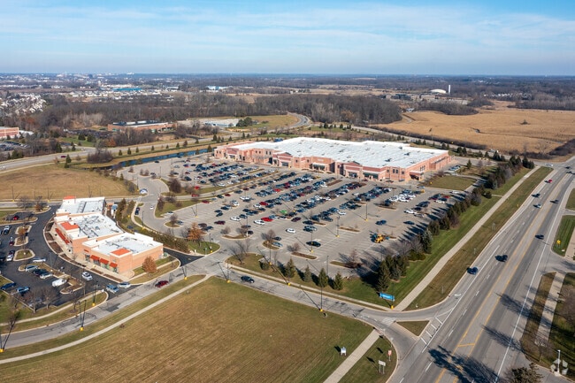
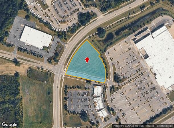
6831 State Rd
Ann Arbor, MI
State Street Crossing Condominium
12-28-301-001
CONDO NAME: WASHTENAW COUNTY CONDOMINIUM SUBDIVISION PLAN NO 543
Commercialacreage
Washtenaw
X
Michigan
26161C0405E
2.48 AC
2025
Washtenaw W of 23
2025
Detroit
423400
DEMOGRAPHICS near 6831 State Rd
1 Mile
3 Mile
5 Mile
2024 Total Population
2,517
24,383
79,394
2029 Population
2,522
24,112
78,624
Pop Growth 2024-2029
+ 0.20%
(1.11%)
(0.97%)
Average Age
39
42
41
2024 Total Households
859
8,940
33,013
HH Growth 2024-2029
+ 0.23%
(1.33%)
(1.13%)
Median Household Inc
$137,236
$114,526
$90,539
Avg Household Size
2.80
2.50
2.30
2024 Avg HH Vehicles
2.00
2.00
2.00
Median Home Value
$480,516
$391,594
$359,802
Median Year Built
2002
1992
1985
Nearby Places
Map Layers
Map Styles
 Street
 Aerial
- Restaurants
- Banks
- Shops
- Fitness
- Groceries
PUBLIC TRANSPORTATION
COMMUTER RAIL
Ann Arbor Amtrak Station (Wolverine - Amtrak)
DRIVE
WALK
Distance
Ann Arbor Amtrak Station (Wolverine - Amtrak)
16 min
7.3 mi
AIRPORT
Detroit Metro Wayne County
DRIVE
WALK
Distance
Detroit Metro Wayne County
32 min
24.8 mi
Freight Ports
Port of Toledo
DRIVE
WALK
Distance
Port of Toledo
72 min
53.5 mi
SALE & LEASE HISTORY
LISTING DATE
SALE/LEASE

Sep 25, 2016
For Lease
Nearby Properties
Address
Land Use
TOTAL SIZE
Lot Size
Zoning
Address
Land Use
TOTAL SIZE
Lot Size
Zoning
282,382 SF
305.53 AC
RPD
Address
Land Use
TOTAL SIZE
Lot Size
Zoning
112,994 SF
45.12 AC
IH
Address
Land Use
TOTAL SIZE
Lot Size
Zoning
140,039 SF
Address
Land Use
TOTAL SIZE
Lot Size
Zoning
139,500 SF
A-1
Address
Land Use
TOTAL SIZE
Lot Size
Zoning
253,702 SF
30.23 AC
Address
Land Use
TOTAL SIZE
Lot Size
Zoning
18,148 SF
21.62 AC
BI
Address
Land Use
TOTAL SIZE
Lot Size
Zoning
167,294 SF
40.67 AC
Address
Land Use
TOTAL SIZE
Lot Size
Zoning
159,947 SF
14.19 AC
Address
Land Use
TOTAL SIZE
Lot Size
Zoning
105,615 SF
26.31 AC
Address
Land Use
TOTAL SIZE
Lot Size
Zoning
1,562,480 SF
189.08 AC
I-4
Address
Land Use
TOTAL SIZE
Lot Size
Zoning
191,215 SF
30.23 AC
Address
Land Use
TOTAL SIZE
Lot Size
Zoning
100,136 SF
3.47 AC
C2B
Address
Land Use
TOTAL SIZE
Lot Size
Zoning
17,228 SF
8.40 AC
Address
Land Use
TOTAL SIZE
Lot Size
Zoning
99,663 SF
6.89 AC
R-1A
Address
Land Use
TOTAL SIZE
Lot Size
Zoning
154,987 SF
17.08 AC
II
Address
Land Use
TOTAL SIZE
Lot Size
Zoning
4,964 SF
5.86 AC
Address
Land Use
TOTAL SIZE
Lot Size
Zoning
88,657 SF
14.98 AC
Address
Land Use
TOTAL SIZE
Lot Size
Zoning
67,220 SF
9 AC
Address
Land Use
TOTAL SIZE
Lot Size
Zoning
255,838 SF
31.64 AC
II
Address
Land Use
TOTAL SIZE
Lot Size
Zoning
99,000 SF
12.22 AC
I-2
Address
Land Use
TOTAL SIZE
Lot Size
Zoning
76,204 SF
12.41 AC
Address
Land Use
TOTAL SIZE
Lot Size
Zoning
60,362 SF
7.69 AC
Address
Land Use
TOTAL SIZE
Lot Size
Zoning
140,284 SF
6.83 AC
I-2
Address
Land Use
TOTAL SIZE
Lot Size
Zoning
54,607 SF
14.17 AC
Address
Land Use
TOTAL SIZE
Lot Size
Zoning
84,415 SF
9.96 AC
II
Address
Land Use
TOTAL SIZE
Lot Size
Zoning
68,866 SF
24.96 AC
II
Address
Land Use
TOTAL SIZE
Lot Size
Zoning
65,899 SF
6.37 AC
R-3
Address
Land Use
TOTAL SIZE
Lot Size
Zoning
60,568 SF
7.69 AC
Address
Land Use
TOTAL SIZE
Lot Size
Zoning
179,324 SF
14.91 AC
I-2
Address
Land Use
TOTAL SIZE
Lot Size
Zoning
105,418 SF
9.47 AC
I-2
The World's #1 Commercial Real Estate Marketplace
Connect with us
© 2026 CoStar Group
The information above has been obtained from sources believed reliable. While we do not doubt its accuracy we have not verified it and make no guarantee, warranty or representation about it. It is your responsibility to independently confirm its accuracy and completeness. Any projections, opinions, assumptions, or estimates used are for example only and do not represent the current or future performance of the property. The value of this transaction to you depends on tax and other factors which should be evaluated by your tax, financial, and legal advisors. You and your advisors should conduct a careful, independent investigation of the property to determine to your satisfaction the suitability of the property for your needs.