Property Record
684 Main St, Rockland, ME 04841


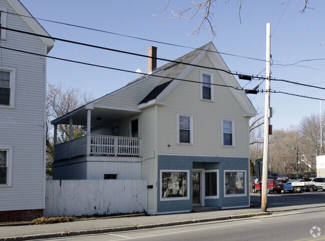
Property Detail
684 Main St
ROCD-000013C-000000-004000
KNOX
Commercialofficeresidentialmixeduse
Maine
B and X Area of moderate flood hazard, usually the area between the limits of the 100-year and 500-year floods.
4000
2025
0.13 AC
2025
Other Market Areas
970700
NEARBY LISTINGS FOR SALE OR LEASE
DEMOGRAPHICS near 684 Main St
1 mile
3 mile
5 mile
2025 Total Population
5,044
9,143
13,985
2030 Population
5,035
9,150
13,938
Pop Growth 2025-2030
(0.18%)
+ 0.08%
(0.34%)
Average Age
46
47
47
2025 Total Households
2,510
4,384
6,524
HH Growth 2025-2030
(0.16%)
+ 0.07%
(0.34%)
Median Household Inc
$59,897
$61,578
$66,276
Avg Household Size
1.90
2.00
2.10
2025 Avg HH Vehicles
1.00
2.00
2.00
Median Home Value
$281,927
$305,686
$302,497
Median Year Built
1949
1963
1968
Nearby Places
Map Layers
Map Styles
 Street
 Aerial
Layers
 Traffic
 Biking
Places
Listings with unknown addresses are not visible on the map
- Restaurants
- Banks
- Shops
- Fitness
- Groceries
Nearby Properties
Address
Land Use
TOTAL SIZE
Lot Size
Zoning
Address
Land Use
TOTAL SIZE
Lot Size
Zoning
4.29 AC
Address
Land Use
TOTAL SIZE
Lot Size
Zoning
194,179 SF
164.63 AC
Address
Land Use
TOTAL SIZE
Lot Size
Zoning
91,666 SF
7.31 AC
Address
Land Use
TOTAL SIZE
Lot Size
Zoning
171,375 SF
63.35 AC
Address
Land Use
TOTAL SIZE
Lot Size
Zoning
5.74 AC
Address
Land Use
TOTAL SIZE
Lot Size
Zoning
145,347 SF
30.22 AC
HC
Address
Land Use
TOTAL SIZE
Lot Size
Zoning
2,460 SF
5.46 AC
Address
Land Use
TOTAL SIZE
Lot Size
Zoning
170,216 SF
17.20 AC
Address
Land Use
TOTAL SIZE
Lot Size
Zoning
3,577 SF
20.94 AC
Address
Land Use
TOTAL SIZE
Lot Size
Zoning
66,328 SF
11.52 AC
Address
Land Use
TOTAL SIZE
Lot Size
Zoning
195,140 SF
25.07 AC
Address
Land Use
TOTAL SIZE
Lot Size
Zoning
142,400 SF
19.68 AC
HC
Address
Land Use
TOTAL SIZE
Lot Size
Zoning
89,510 SF
22.15 AC
Address
Land Use
TOTAL SIZE
Lot Size
Zoning
50,910 SF
2.15 AC
HC
Address
Land Use
TOTAL SIZE
Lot Size
Zoning
43.89 AC
Address
Land Use
TOTAL SIZE
Lot Size
Zoning
24.33 AC
Address
Land Use
TOTAL SIZE
Lot Size
Zoning
96,194 SF
24.39 AC
Address
Land Use
TOTAL SIZE
Lot Size
Zoning
40,774 SF
1.58 AC
Address
Land Use
TOTAL SIZE
Lot Size
Zoning
39,342 SF
1 AC
Address
Land Use
TOTAL SIZE
Lot Size
Zoning
77,458 SF
7.16 AC
Address
Land Use
TOTAL SIZE
Lot Size
Zoning
2.51 AC
Address
Land Use
TOTAL SIZE
Lot Size
Zoning
10 AC
RA
Address
Land Use
TOTAL SIZE
Lot Size
Zoning
55,298 SF
2.41 AC
Address
Land Use
TOTAL SIZE
Lot Size
Zoning
22,110 SF
22.61 AC
HC
Address
Land Use
TOTAL SIZE
Lot Size
Zoning
4.11 AC
Address
Land Use
TOTAL SIZE
Lot Size
Zoning
1,900 SF
69.45 AC
Address
Land Use
TOTAL SIZE
Lot Size
Zoning
40,256 SF
1.10 AC
Address
Land Use
TOTAL SIZE
Lot Size
Zoning
233,776 SF
16.36 AC
Address
Land Use
TOTAL SIZE
Lot Size
Zoning
27,000 SF
19.33 AC
Address
Land Use
TOTAL SIZE
Lot Size
Zoning
2.82 AC
The World's #1 Commercial Real Estate Marketplace
Connect with us
© 2026 CoStar Group
The information above has been obtained from sources believed reliable. While we do not doubt its accuracy we have not verified it and make no guarantee, warranty or representation about it. It is your responsibility to independently confirm its accuracy and completeness. Any projections, opinions, assumptions, or estimates used are for example only and do not represent the current or future performance of the property. The value of this transaction to you depends on tax and other factors which should be evaluated by your tax, financial, and legal advisors. You and your advisors should conduct a careful, independent investigation of the property to determine to your satisfaction the suitability of the property for your needs.