Property Record
6841 Edmund Hwy, Lexington, SC 29073
NEARBY LISTINGS FOR SALE OR LEASE
-
-
View all Lexington listings for sale on LoopNet.com
Property Detail
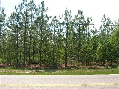
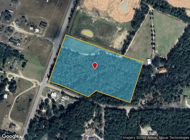
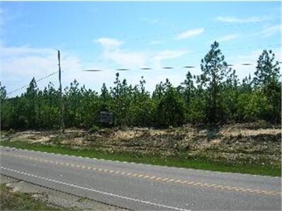
6841 Edmund Hwy
Columbia, SC
Summary Plat
009800-01-028
TRACT C
Agriculturalland
Lexington
X
South Carolina
45063C0380J
9.66 AC
2025
Outlying Lexington County
2024
Columbia
021051
DEMOGRAPHICS near 6841 Edmund Hwy
1 Mile
3 Mile
5 Mile
2024 Total Population
1,285
7,268
18,794
2029 Population
1,416
8,005
20,726
Pop Growth 2024-2029
+ 10.19%
+ 10.14%
+ 10.28%
Average Age
39
39
38
2024 Total Households
484
2,734
6,969
HH Growth 2024-2029
+ 10.33%
+ 10.28%
+ 10.42%
Median Household Inc
$44,166
$47,156
$47,515
Avg Household Size
2.60
2.60
2.60
2024 Avg HH Vehicles
2.00
2.00
2.00
Median Home Value
$130,555
$115,511
$114,892
Median Year Built
1994
1994
1995
Nearby Places
Map Layers
Map Styles
 Street
 Aerial
- Restaurants
- Banks
- Shops
- Fitness
- Groceries
PUBLIC TRANSPORTATION
AIRPORT
Columbia Metro
DRIVE
WALK
Distance
Columbia Metro
23 min
11.2 mi
Freight Ports
North Charleston Terminal
DRIVE
WALK
Distance
North Charleston Terminal
128 min
101.0 mi
Nearby Properties
Address
Land Use
TOTAL SIZE
Lot Size
Zoning
Address
Land Use
TOTAL SIZE
Lot Size
Zoning
9,165 SF
1.71 AC
ID
Address
Land Use
TOTAL SIZE
Lot Size
Zoning
6,250 SF
10.15 AC
LR
Address
Land Use
TOTAL SIZE
Lot Size
Zoning
600 SF
234.68 AC
ID
Address
Land Use
TOTAL SIZE
Lot Size
Zoning
297.10 AC
LR
Address
Land Use
TOTAL SIZE
Lot Size
Zoning
4,500 SF
1.25 AC
ID
Address
Land Use
TOTAL SIZE
Lot Size
Zoning
6,000 SF
1.74 AC
LR
Address
Land Use
TOTAL SIZE
Lot Size
Zoning
305.90 AC
RD
Address
Land Use
TOTAL SIZE
Lot Size
Zoning
5,076 SF
6.05 AC
LR
Address
Land Use
TOTAL SIZE
Lot Size
Zoning
2,000 SF
1.07 AC
ID
Address
Land Use
TOTAL SIZE
Lot Size
Zoning
12,000 SF
3.26 AC
ID
Address
Land Use
TOTAL SIZE
Lot Size
Zoning
3,750 SF
1.41 AC
RL
Address
Land Use
TOTAL SIZE
Lot Size
Zoning
4,102 SF
1.36 AC
Address
Land Use
TOTAL SIZE
Lot Size
Zoning
26.86 AC
LR
Address
Land Use
TOTAL SIZE
Lot Size
Zoning
70.79 AC
RD
Address
Land Use
TOTAL SIZE
Lot Size
Zoning
5,400 SF
3.04 AC
ID
Address
Land Use
TOTAL SIZE
Lot Size
Zoning
14,000 SF
2.66 AC
ID
Address
Land Use
TOTAL SIZE
Lot Size
Zoning
11,940 SF
2.35 AC
ID
Address
Land Use
TOTAL SIZE
Lot Size
Zoning
26.87 AC
ID
Address
Land Use
TOTAL SIZE
Lot Size
Zoning
154.76 AC
RD
Address
Land Use
TOTAL SIZE
Lot Size
Zoning
147.66 AC
LR
Address
Land Use
TOTAL SIZE
Lot Size
Zoning
1,200 SF
0.90 AC
ID
Address
Land Use
TOTAL SIZE
Lot Size
Zoning
3,600 SF
1.42 AC
ID
Address
Land Use
TOTAL SIZE
Lot Size
Zoning
129.57 AC
LR
Address
Land Use
TOTAL SIZE
Lot Size
Zoning
5,000 SF
0.86 AC
ID
Address
Land Use
TOTAL SIZE
Lot Size
Zoning
3,400 SF
0.51 AC
C1
Address
Land Use
TOTAL SIZE
Lot Size
Zoning
114.42 AC
RD
Address
Land Use
TOTAL SIZE
Lot Size
Zoning
91.91 AC
Address
Land Use
TOTAL SIZE
Lot Size
Zoning
4,500 SF
1.02 AC
ID
Address
Land Use
TOTAL SIZE
Lot Size
Zoning
2.62 AC
ID
Address
Land Use
TOTAL SIZE
Lot Size
Zoning
85.71 AC
The World's #1 Commercial Real Estate Marketplace
Connect with us
© 2026 CoStar Group
The information above has been obtained from sources believed reliable. While we do not doubt its accuracy we have not verified it and make no guarantee, warranty or representation about it. It is your responsibility to independently confirm its accuracy and completeness. Any projections, opinions, assumptions, or estimates used are for example only and do not represent the current or future performance of the property. The value of this transaction to you depends on tax and other factors which should be evaluated by your tax, financial, and legal advisors. You and your advisors should conduct a careful, independent investigation of the property to determine to your satisfaction the suitability of the property for your needs.