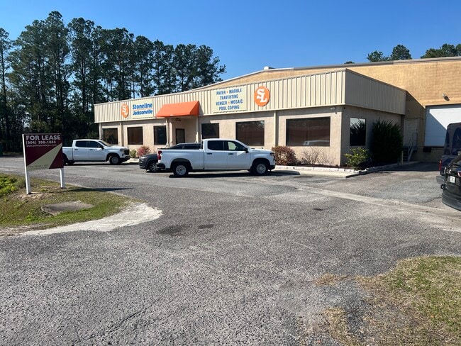
Property Record
6841 Phillips Parkway Dr S, Jacksonville, FL 32256


Current Lease Availabilities
NEARBY LISTINGS FOR SALE OR LEASE
Property Detail
6841 Phillips Parkway Dr S
Jacksonville, FL
Phillips Highway South
167865-1006
38-56 08-4S-28E 1.13 PHILLIPS HIGHWAY SOUTH LOT 14(EX PT IN R/W RECD O/R 7833-1381) BLK 2
Warehouse
Duval
X
Florida
12031C0566H
14
2025
1.13 AC
2026
Butler Corridor
014423
Jacksonville (Florida)
23,795 SF
DEMOGRAPHICS near 6841 Phillips Parkway Dr S
1 Mile
3 Mile
5 Mile
2024 Total Population
3,074
41,822
137,684
2029 Population
3,373
44,388
149,276
Pop Growth 2024-2029
+ 9.73%
+ 6.14%
+ 8.42%
Average Age
41
39
39
2024 Total Households
1,159
17,091
56,877
HH Growth 2024-2029
+ 9.75%
+ 6.20%
+ 7.86%
Median Household Inc
$71,363
$85,800
$81,041
Avg Household Size
2.40
2.40
2.40
2024 Avg HH Vehicles
2.00
2.00
2.00
Median Home Value
$405,050
$297,971
$313,783
Median Year Built
2005
2002
1999
Nearby Places
Map Layers
Map Styles
 Street
 Aerial
- Restaurants
- Banks
- Shops
- Fitness
- Groceries
PUBLIC TRANSPORTATION
AIRPORT
Jacksonville International
DRIVE
WALK
Distance
Jacksonville International
42 min
30.5 mi
Nearby Properties
Address
Land Use
TOTAL SIZE
Lot Size
Zoning
Address
Land Use
TOTAL SIZE
Lot Size
Zoning
879,352 SF
31.37 AC
PUD
Address
Land Use
TOTAL SIZE
Lot Size
Zoning
1,013,318 SF
131.30 AC
PUD
Address
Land Use
TOTAL SIZE
Lot Size
Zoning
534,591 SF
39.81 AC
PUD
Address
Land Use
TOTAL SIZE
Lot Size
Zoning
723,629 SF
18.30 AC
PUD
Address
Land Use
TOTAL SIZE
Lot Size
Zoning
470,627 SF
21.61 AC
PUD
Address
Land Use
TOTAL SIZE
Lot Size
Zoning
345,678 SF
30.40 AC
PUD
Address
Land Use
TOTAL SIZE
Lot Size
Zoning
810,921 SF
58.85 AC
PUD
Address
Land Use
TOTAL SIZE
Lot Size
Zoning
243,751 SF
15.29 AC
PUD
Address
Land Use
TOTAL SIZE
Lot Size
Zoning
262,781 SF
11.40 AC
PUD
Address
Land Use
TOTAL SIZE
Lot Size
Zoning
250,708 SF
13.52 AC
PUD
Address
Land Use
TOTAL SIZE
Lot Size
Zoning
340,852 SF
19.65 AC
PUD
Address
Land Use
TOTAL SIZE
Lot Size
Zoning
298,018 SF
15.53 AC
PUD
Address
Land Use
TOTAL SIZE
Lot Size
Zoning
215,194 SF
58.34 AC
PUD
Address
Land Use
TOTAL SIZE
Lot Size
Zoning
271,074 SF
17.77 AC
CCG-1
Address
Land Use
TOTAL SIZE
Lot Size
Zoning
358,537 SF
29.16 AC
RMD-C
Address
Land Use
TOTAL SIZE
Lot Size
Zoning
276,262 SF
10.01 AC
PUD
Address
Land Use
TOTAL SIZE
Lot Size
Zoning
569,816 SF
17.76 AC
PUD
Address
Land Use
TOTAL SIZE
Lot Size
Zoning
264,962 SF
11.24 AC
PUD
Address
Land Use
TOTAL SIZE
Lot Size
Zoning
330,037 SF
28.33 AC
RMD-C
Address
Land Use
TOTAL SIZE
Lot Size
Zoning
262,043 SF
10.89 AC
PUD
Address
Land Use
TOTAL SIZE
Lot Size
Zoning
158,114 SF
5.73 AC
PUD
Address
Land Use
TOTAL SIZE
Lot Size
Zoning
356,254 SF
22.04 AC
PUD
Address
Land Use
TOTAL SIZE
Lot Size
Zoning
485,498 SF
12.25 AC
PUD
Address
Land Use
TOTAL SIZE
Lot Size
Zoning
310,849 SF
16.16 AC
RMD-C
Address
Land Use
TOTAL SIZE
Lot Size
Zoning
215,287 SF
29.59 AC
PUD
Address
Land Use
TOTAL SIZE
Lot Size
Zoning
171,277 SF
7.36 AC
PUD
Address
Land Use
TOTAL SIZE
Lot Size
Zoning
250,507 SF
26.01 AC
PUD
Address
Land Use
TOTAL SIZE
Lot Size
Zoning
304,277 SF
25.03 AC
CCG-2
Address
Land Use
TOTAL SIZE
Lot Size
Zoning
119,560 SF
22.05 AC
PUD
Address
Land Use
TOTAL SIZE
Lot Size
Zoning
230,730 SF
42.22 AC
PBF-2
The World's #1 Commercial Real Estate Marketplace
Connect with us
© 2025 CoStar Group
The information above has been obtained from sources believed reliable. While we do not doubt its accuracy we have not verified it and make no guarantee, warranty or representation about it. It is your responsibility to independently confirm its accuracy and completeness. Any projections, opinions, assumptions, or estimates used are for example only and do not represent the current or future performance of the property. The value of this transaction to you depends on tax and other factors which should be evaluated by your tax, financial, and legal advisors. You and your advisors should conduct a careful, independent investigation of the property to determine to your satisfaction the suitability of the property for your needs.